JAC Board Class 9th Social Science Solutions Geography Chapter 4 Climate
JAC Class 9th Geography Climate InText Questions and Answers
Find Out (Page No. 27)
Question 1.
Why the houses in Rajasthan have thick walls and flat roofs?
Answer:
Rajasthan lies mostly in desert where the climate remains very hot. Due to lack of vegetation, here the sunrays fall directly on the earth. Also the winds blow very fast here. Therefore, the houses have thick walls to maintain the inner temperature of the houses and keep them cool for longer time. They have flat roofs to collect the rainwater because there is scarcity of water in Rajasthan.
Question 2.
Why is the houses in the Tarai region and in Goa & Mangalore have sloping roofs?
Answer:
The Tarai region, Goa and Mangalore are places receiving heavy rainfall throughout the year. Therefore, the houses in these regions have sloping roofs to allow the rainwater to flow down speedily. Non-accumulation of water allows sloping roofs being safe during rainy season.
![]()
Question 3.
Why houses in Assam are built on stilts?
Answer:
In Assam, the average rainfall is above 300 cm. Due to heavy rainfall throughout the year, the ground always remains wet. Stilts allow free flow of water on the ground and the houses are not flooded. Therefore, houses are built on stilts to avoid wetness and danger from poisonous reptiles living on the wet ground.
Question 4.
Why most of the World’s deserts are located in the western margins of continents in the sub-tropics ?
Answer:
Most of the world’s deserts are located in the western margins of continents in the sub-tropics because the prevailing winds in the tropics are tropical easterly winds. These winds become dry by the time they reach the western margins of the continents and so they bring no rainfall. Thus, the region becomes moisture-less which causes dry conditions leading to formation of deserts.
Activity (Page No. 38)
Question 1.
1. On the basis of the news items above, find out the names of places and the seasons described.
2. Compare the rainfall description of Chennai and Mumbai and explain the reasons for the difference.
3. Evaluate flood as a disaster with the help of a case study.
Answer:
- Rainy season Mumbai & Chennai
Winter Season Srinagar, Amritsar, Shimla and New Delhi. - Chennai receives winter rains while Mumbai monsoonal rains. In Chennai, rainfall is less than that in Mumbai.
The main reason behind this difference is that both Mumbai and Chennai are situated in different monsoon regions. - Students are requested to perform the activity on themselves.
JAC Class 9th Geography Climate Textbook Questions and Answers
Question 1.
Choose the correct answer from the four alternatives given below:
1. Which one of the following places receives the highest rainfall in the world?
(a) Silchar
(b) Mawsynram
(c) Cherrapunji
(d) Guwahati.
Answer:
(b) Mawsynram
2. The wind blowing in the Northern plains in summers is known as :
(a) Kal Baisakhi
(b) Loo
(c) Trade winds
(d) None of these
Answer:
(b) Loo
3. Which one of the following causes rainfall during winters in north-western part of India?
(a) Cyclonic depression
(b) Retreating monsoon
(c) Western disturbances
(d) South-west monsoon
Answer:
(c) Western disturbances
4. Monsoon arrives in India as early in:
(a) May
(b) July
(c) June
(d) August
Answer:
(c) June
5. Which one of the following characterises the cold weather season in India?
(a) warm days and warm nights
(b) warm days and cold nights
(c) cold days and cold nights
(d) cold days and warm nights
Answer:
(b) warm days and cold nights
![]()
Question 2.
Answer the following questions briefly :
1. What are the controls affecting the climate of India?
Answer:
There are six major controls affecting the climate of India. They are: latitude, altitude, pressure and wind system, distance from the sea, ocean currents and relief features.
2. Why does India have a monsoon type of climate?
Answer:
India has a monsoon type of climate because there is a seasonal reversal in the wind system of India. During 6 months, monsoon winds blow from sea to land, and during the next 6 months, they blow from land to sea. Monsoon winds prevails between 5° and 30° latitudes on both sides of the Equator. India lies in between these latitudes, thus, it is greatly influenced by monsoon winds.
3. Which part of India does experience the highest diurnal range of temperature and why?
Answer:
The Thar desert of Rajasthan in India experiences the highest diurnal range of
temperature. It is because in the Thar desert, the weather conditions drastically change from the day to the night. During the day, there is very high temperature, while during the night, the temperature falls down significantly.
4. Which winds account for rainfall along the Malabar coast?
Answer:
South-west monsoon winds account for rainfall along the Malabar coast.
5. What are Jet streams and how do they affect the climate of India?
Answer:
Jet streams are the narrow belt of high altitude (above 12,000 m) westerly winds in the
troposphere. Their speed varies from about 110 km/h in summer to about 184 km/h in winter.
In India, these jet streams blow from south of the Himalayas, throughout the year, except in summer. The western cyclonic disturbances experienced in the north and north-western parts of the country are brought in by this westerly flow.
6. Define monsoon. What do you understand by “break” in monsoon?
Answer:
Monsoon: The word monsoon is derived from the Arabic word ‘Mausim’, which literally means season. ‘Monsoon’ refers to the seasonal reversal in the wind direction during a year. Break in Monsoon: Rains taking place only for a few days at a time is called “break in monsoon”. In brief, the intermission amid raining is termed as “break’ in monsoon. It is related to the movement of the monsoon.
7. Why is the monsoon considered a unifying bond?
Answer:
India is a vast country. Here variations are found not only in relief, climate and vegetation, but also in life. But the monsoon is a geographical factor that binds these variations of the country together and establishes unity. The arrival of the monsoon brings rains all over the country. Monsoon winds speed up the process of agriculture by providing water to us.
The entire Indian landscape, its wildlife and vegetation life, the entire agricultural program, the lifestyle of the people and their festivals, all revolve around the monsoon. Due to the monsoon, there is a rhythm of the cycle of seasons every years. This is the reason why the monsoon is considered a unifying bond.
![]()
Question 3.
Why does the rainfall decrease from the east to the west in Northern India?
Answer:
When the Bay of Bengal branch of south-west monsoon is obstructed by the eastern Himalayas, maximum amount of rainfall is received in West Bengal, Bihar etc. When these winds advance towards west, they go on shedding moisture. Therefore, the amount of rainfall decreases from the east to the west in Northern India.
Question 4.
Give reasons as to why:
1. Seasonal reversal of wind direction takes place over the Indian sub-continent?
Answer:
Reasons for the seasonal reversal of wind direction takes place over the Indian sub-continent are the following:
(a) During winter, there is a high-pressure area over north of the Himalayas. Cold dry winds blow from this region to the low pressure area over the oceans to the south.
(b) In summer, a low-pressure area develops over interior Asia as well as over north-western India. This causes a complete reversal of the direction of winds during summer.
2. The bulk of rainfall in India is concentrated over a few months.
Answer:
In India, most of the rainfall is caused by south-west monsoon which prevails in India only between June to September. Therefore, bulk of rainfall in India is concentrated in these four months only.
3. The Tamil Nadu coast receives winter rainfall.
Answer:
The north-east monsoon winds starts blowing in October month from the land, i.e., north-eastern parts of India to the sea. These bear no water till their access to the Bay of Bengal. However, they get some moisture from the sea here and cause rain in the coast of Tamil Nadu.
4. The delta region of the eastern coast is frequently struck by cyclones.
Answer:
The delta region of the Eastern coast of India is frequently struck by cyclones. This is because the cyclonic depressions that originate over the Andaman Sea are brought in by the sub-tropical easterly jet stream balancing over Peninsular India during the monsoon as well as during the October to November period. The depression moves along East to West direction thus hitting the Eastern coasts.
5. Parts of Rajasthan, Gujarat and the leeward side of the Western Ghats are drought- prone.
Answer:
This happens due to collision of rain bearing Arabian Sea branch of monsoon winds against the highly elevated Western Ghats and depletion of water there. Again, the Aravali hills, being not much elevated, the monsoon winds pass from there without causing rainfall.
![]()
Question 5.
Describe the regional variations in the climatic conditions of India with the help of suitable examples.
Answer:
The regional variations in the climatic conditions of India can be understood in the following ways :
1. Temperature:
In summer, the temperature occasionally reaches 50°C in some parts of the Rajasthan’s desert area, whereas it may be around 20°C in Pahalgam in Jammu and Kashmir. On a winter night, temperature at Drass in Jammu and Kashmir may be as low as – 45°C, while Thiruvananthapuram, on the other hand, may have a temperature of 22°G.
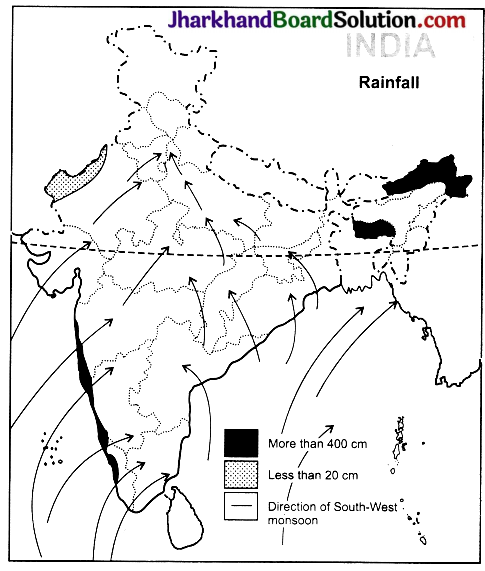
2. Rainfall:
Most parts of the country receive rainfall from June to September, but some parts like Tamil Nadu coast get a large portion of rainfall during October and November. The annual precipitation also varies from over 400 cm in Meghalaya to less than 10 cm in Ladakh and Western Rajasthan.
3. Form of precipitation:
While precipitation is mostly in the form of snowfall in the upper parts of Himalayas, it rains over the rest of the country.
4. Direction of winds:
During summer, winds move from sea to land, while during winter, winds move from land to sea.
Question 6.
Discuss the mechanism of monsoon.
Answer:
The monsoons are experienced in the tropical areas roughly between 20°N and 20°S. To understand the mechanism of the monsoon, the following facts are important:
- The differential heating and cooling of land and water creates low pressure on the landmass of India, while the seas around experience comparatively high pressure.
- The shift of the position of Inter Tropical Convergence Zone (ITCZ) in summer, over the Ganga plain (this is the equitorial trough normally positioned about 5° N of the equator. It is also known as the monsoon trough during the monsoon season.)
- The presence of the high-pressure area, east of Madagascar, approximately at 20°S over the Indian Ocean. The intensity and position of this high-pressure area affects the Indian monsoon.
- The Tibetan plateau get intensely heated during summer, which results in strong vertical air currents and the formation of low pressure over the plateau at about 9 km above sea level.
- The movement of the westerly jet stream to the north of the Himalayas and the presence of the tropical easterly jet stream over the Indian peninsula during summer.
Question 7.
Give an account of weather conditions and characteristics of the cold season.
Answer:
Weather Conditions of the Cold Season: An account of weather conditions of the cold season is as followin :
1. Time period of the cold season:
The cold weather season begins from mid-November in Northern India and stays till February. December and January are the coldest months in the Northern part of India.
2. Temperature:
The temperature decreases from south to the north. The average temperature of Chennai, on the eastern coast, is between 24°-25°C, while in the northern plains, it ranges between 10°-15°C. Days are warm and nights are cold. Frost is common in the north and the highest slopes of the Himalayas experience snowfall.
3. Winds:
During this season, the north-east trade winds prevail over the country, it is a dry season.
4. Rainfall:
Some amount of rainfall occurs on the Tamil Nadu coast from these winds as here they blow from sea to land.
5. Air pressure:
In the northern part of the country, a feeble high-pressure region develops, with light winds moving outwards from this area.
6. Cyclonic disturbances:
A characteristic feature of the cold weather season over the northern plains is the inflow of cyclonic disturbances from the west and the north-west. These low-pressure systems originate over the Mediterranean Sea and Western Asia and move into India, along with the westerly flow. They cause the much-needed winter rains over the plains and snow fall in the mountains.
7. Characteristics of the Cold Season:
Clear sky, pleasant weather, low temperature and humidity, high range of temperature, cool and slow northern winds are the main characteristics of this season.
![]()
Question 8
Give the characteristics and effects of the monsoon rainfall in India.
Answer:
Characteristics of the Monsoon Rainfall: Several characteristic features of the monsoon rainfall are the following :
- Most of the country gets rainfall from south-west monsoons.
- The rainfall from the monsoon winds is variable and quite undependable.
- Much of the rainfall is received in 3-4 months.
- The distribution of rainfall is highly uneven.
- Indian rainfall is controlled by orography, i.e., most of the rainfall is caused due to the obstruction of moisture bearing winds.
Effects of the Monsoon Rainfall: The effects of the monsoon rainfall are as hereunder.
1. South-west monsoon does not cause rain regularly. Its amount also varies from year to year.
2. After heavy rainfall, there is decrease in its quantity. Sometimes, long duration of rainy season passes even without rains.
3. Cyclones at the head of the Bay of Bengal control the effectiveness of monsoon winds. From June to September, the number of cyclones is about 8. Intense cyclones give strength to Monsoon winds and helps in causing heavy rainfall, their less intensity causes dry spells.
4. Monsoon trough of low pressure situated over the north plains also affects the distribution of rainfall. The axis of the trough close to the Himalayas causes heavy rains in the mountains and floods in the plains resulting in a great loss to man and material.
5. Success or failure of agricultural crops depends on the amount of rainfall. Thus, Indian agriculture still remains ‘A Gamble to Monsoon’, though, we have tapped irrigation potential to a great extent.
![]()
Question 9.
On an outline map of India, show the following:
1. Areas receiving rainfall over 400 cm.
2. Areas receiving less than 20 cm of rainfall.
3. The direction of the south-west monsoon over India.
Answer:
1. Find out which songs, dances, festivals and special food preparations are associated with certain seasons in your region. Do they have some commonality with other regions of India?
Answer:
Students, do it yourself with the help of your teacher.
2. Collect photographs of typical rural houses, and clothing of people from different regions of India. Examine whether they reflect any relationship with the climatic condition and relief of the area.
Answer:
Students, do it yourself with the help of your teacher.
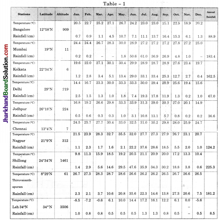
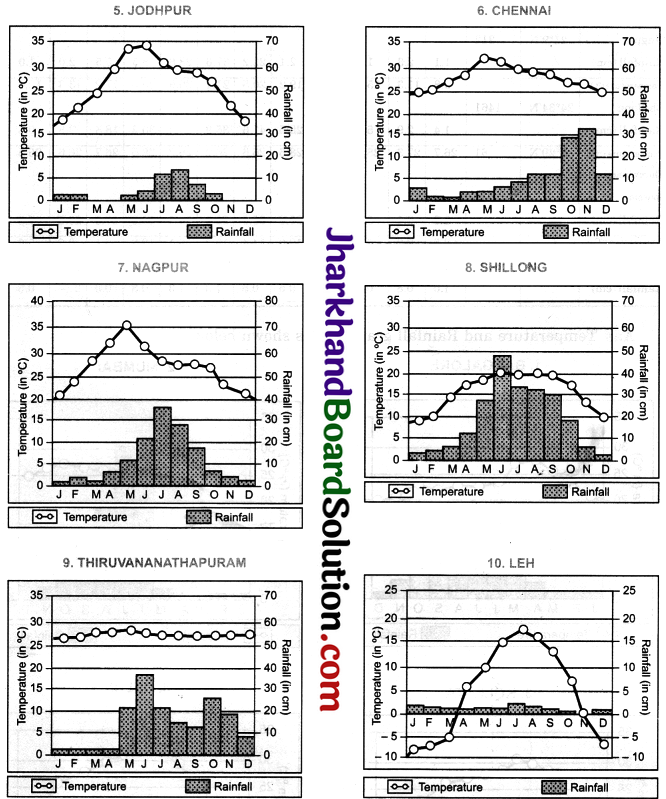
Question 1.
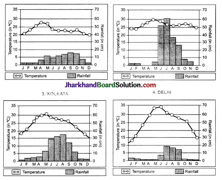
In table-I, the average mean monthly temperatures and amounts of rainfall of 10 representative stations have been given. It is for you to study on your own and convert them into ‘temperature and rainfall’ graphs. A glance at these visual representations will help you to grasp instantly the similarities and differences between them. One such graph (Figure 1) is already prepared for you. See if you can arrive at some broad generalisations about our diverse climatic conditions. We hope you are in for a great joy of learning. Do the following activities.
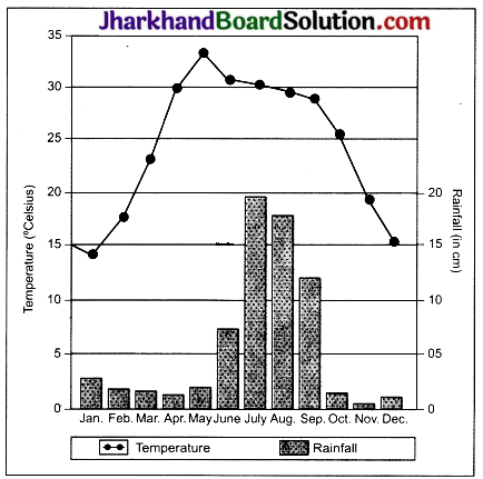
Answer:
Temperature and Rainfall graph are as shown below:
Question 2.
Re-arrange the 10 stations in two different sequences:
1. According to their distance from the equator.
2. According to their altitude above mean sea-level.
Answer:
1. According to their distance from the equator:
| 1. Thiruvananthapuram | 8°29′ N |
| 2. Bangalore | 12°58′ N |
| 3. Chennai | 13°4′ N |
| 4. Mumbai | 19° N |
| 5. Nagpur | 21°9′ N |
| 6. Kolkata | 22°34′ N |
| 7. Shillong | 24°34′ N |
| 8. Jodhpur | 26° 18′ N |
| 9. Delhi | 29° N |
| 10. Leh | 34° N |
2. According to their altitude above mean sea-level:
| 1. Kolkata | 6 m |
| 2. Chennai | 7 m |
| 3. Mumbai | 11 m |
| 4. Thiruvananthapuram | 61 m |
| 5. Delhi | 219 m |
| 6. Jodhpur | 224 m |
| 7. Nagpur | 312 m |
| 8. Bangalore | 909 m |
| 9. Shillong | 1461 m |
| 10. Leh | 3506 m |
![]()
Question 3.
1. Name two rainiest stations.
2. Name two driest stations.
3. Two stations with most equable climate.
4. Two stations with most extreme climate.
5. Two stations most influenced by the Arabian Sea branch of south-west monsoon.
6. Two stations most influenced by the Bay of Bengal branch of south-west monsoons.
7. Two stations influenced by both branches of the south-west monsoons.
8. Two stations influenced by retreating and north-east monsoons.
9. Two stations receiving winter showers from the western disturbances.
10. The two hottest stations in the months of :
(a) February
(b) April
(c) May
(d) June
Answer:
- Two rainiest stations:
(a) Shillong,
(b) Mumbai. - Two driest stations:
(a) Leh,
(b) Jodhpur. - Two stations with most equable climate:
(a) Mumbai,
(b) Thiruvananthapuram - Two stations with most extreme climate:
(a) Leh,
(b) Jodhpur. - Two stations most influenced by the Arabian sea branch of south-west monsoons:
(a) Mumbai,
(b) Thirvananthapuram. - Two stations most influenced by the Bay of Bengal Branch of south-west monsoons:
(a) Shillong,
(b) Kolkata. - Two stations influenced by both branches:
(a) Nagpur,
(b) Delhi. - Two stations influenced by retreating and north-east monsoons:
(a) Chennai,
(b) Thiruvananthapuram. - Two stations receiving winter showers from the western disturbances:
(a) Delhi,
(b) Leh. - The two hottest stations in the month of:
(a) February: Thiruvananthapuram and Chennai.
(b) April: Nagpur and Chennai.
(c) May: Nagpur and Delhi/Jodhpur.
(d) June: Jodhpur and Delhi.
Question 4.
Now find out:
1. Why are Thiruvananthapuram and Shillong rainier in June than in July?
2. Why is July rainier in Mumbai than in Thiruvananthapuram?
3. Why are south-west monsoons less rainy in Chennai?
4. Why is Shillong rainier than Kolkata?
5. Why is Kolkata rainier in July than in June unlike Shillong which is rainier in June than in July?
6. Why does Delhi receive more rain than Jodhpur?
Answer:
1. Thiruvananthapuram is located in Kerala in the southernmost part of India. By early June, monsoon enters India from the south. One of the branches of monsoon winds, i.e., Bay of Bengal branch hits the hills located around Shillong and showers heavy rainfall. As Thiruvananthapuram and Shillong come first in the way of monsoon winds, they are more rainier in June than in July.
2. In the month of July, the monsoon winds pass from Thiruvananthapuram and enter the interior parts of India, thus, July is less rainier in this city. On the other hand, in Mumbai, the monsoon winds rising from Arabian Sea continuously cause rainfall due to the presence of Western Ghats.
3. The Bay of Bengal branch of south-west monsoons causes heavy rains in the western parts of Western Ghats. Chennai lies in the extremely east. When the monsoon winds reach over there, they become almost dry. Chennai lies in rain-shadow area of south-west monsoon.
4. Shillong is situated on hills which trap the monsoon winds and force them to cause rainfall. But Kolkata is situated in plains where monsoon winds reach comparatively late and there are no such hills which could trap the monsoon winds.
5. South-west monsoon first strikes Shillong and then Kolkata. Thus, Shillong receives more rainfall in June itself and as these winds move on to Kolkata, they start causing rainfall over there in July.
6. Delhi creates barrier in the path of south-west (Bay of Bengal branch) monsoon while Jodhpur does not create any resistance in the path of south-west (Arbian Sea Branch) monsoon.
![]()
Question 5.
Now think why:
1. Thiruvananthapuram has equable climate?
2. Chennai has more rains only after the fury of monsoon is over in most parts of the country?
3. Jodhpur has a hot desert type of climate?
4. Leh has moderate precipitation almost throughout the year?
5. While in Delhi and Jodhpur most of the rain is confined to nearly three months, in Thiruvananthapuram and Shillong it is almost nine months of the year? In spite of these facts see carefully if there are strong evidences to conclude that the monsoons still provide a very strong framework lending overall climatic unity to the whole country.
Answer:
1. Thiruvananthapuram has an equable climate because it is closer to the sea and its climate is moderated by the sea. Being close to the Equator, it is also influenced by the equatorial type of climate where the annual range of temperature happens to be the least.
2. Over the most parts of India, rainfall occurs due to south-west monsoon winds. These winds start retreating in September to October months. At this time, north-east trade winds blow all over India. These winds receive vapour while moving over the Bay of Bengal which immediately carry to the Coromandel coast in Tamil Nadu. Thus, Chennai receives heavy rain during winter season.
3. Jodhpur falls in the rain shadow area and it is situated near to the Thar desert. This station has, therefore, extreme climate. There is also scarce of vegetation. Thus, it has a hot desert type of climate.
4. Leh is situated on the high altitude in Ladakh. Thus, we can see here the precipitation in the form of snow. The lowest temperature also freezes the water. Therefore, Leh has moderate precipitation almost throughout the year.
5. Delhi and Jodhpur are located in the interior parts of country where monsoon winds reach comparatively late. On the other hand, Thiruvananthapuram and Shillong are located on the sea coast where monsoon winds strike first and cause heavy rainfall.