JAC Board Class 9th Social Science Solutions Geography Chapter 2 Physical Features of India
JAC Class 9th Geography Physical Features of India InText Questions and Answers
Find Out (Page No. 8)
Question 1.
The names of the glaciers and passes that lie in the Great Himalayas?
Answer:
Glaciers in the Great Himalayas: Siachin, Milam, Gangotri, Bhagirathi, Baltoro, Pindari.
Passes in the Great Himalayas: Burgil, Zoji La, Shipki La, Bara Lacha La, Nathu La, Bomdi La, Thaga La, Lipulekh La.
![]()
Question 2.
The name of the states where highest peaks are located.
Answer:
| Highest Peaks | States |
| Kanchenjunga | Sikkim |
| Nanga Parbat | Jammu & Kashmir (Union Territory) |
| Nanda Devi | Uttarakhand |
| Kamet | Uttarakhand |
| Namcha Barwa | Arunachal Pradesh |
Question 3.
Find the location of Mussoorie, Nainital, Ranikhet from your atlas and also name the state where they are located.
Answer:
| Place | States |
| Mussoorie | Uttarakhand |
| Nainital | Uttarakhand |
| Ranikhet | Uttarakhand |
JAC Class 9th Geography Physical Features of India Textbook Questions and Answers
Question 1.
Choose the right answer from the four alternatives given below:
1. A landmass bounded by sea on three sides is referred to as:
(a) Coast
(b) Island
(c) Peninsula
(d) None of the above.
Answer:
(c) Peninsula
2. Mountain ranges in the eastern part of India forming its boundary with Myanmar are collectively called as:
(a) Himachal
(b) Uttarakhand
(c) Purvachal
(d) None of the above.
Answer:
(c) Purvachal
3. The Western Coastal Strip, south of Goa is referred to as:
(a) Coromandel
(b) Konkan
(c) Kannad
(d) Northern Circar
Answer:
(c) Kannad
4. The highest peak in the Eastern Ghats is:
(a) Anai Mudi
(b) Kanchenjunga
(c) Mahendragiri
(d) Khasi
Answer:
(c) Mahendragiri
![]()
Question 2.
Answer the following questions briefly:
1. What is the ‘bhabar’?
Answer:
Bhabar is a narrow belt of plain which is about 8 to 16 km wide. It is covered with pebbles deposited by rivers lying parallel to the slopes of the Shiwaliks.
2. Name the three major divisions of the Himalayas from North to South
Answer:
(a) The Great or Inner Himalayas or the ‘Himadri’.
(b) The Middle or Lesser Himalayas or the ‘Himachal’.
(c) The Outer Himalayas or the ‘Shiwaliks’.
3. Which plateau lies between the Aravalli and the Vindhya ranges?
Answer:
The Malwa Plateau.
4. Name the island group of India having a coral origin.
Answer:
The Lakshadweep Islands.
Question 3.
Distinguish between:
1. Bhangar and Khadar
2. Western Ghats and Eastern Ghats.
Answer:
1. Difference between Bhangar and Khadar:
| Bhangar | Khadar |
| 1. It is the older alluvial soil. | 1. It is the newer alluvial soil. |
| 2. It often contains kankar or nodules with calcium carbonates in sub-soil. | 2. It is finer, more sandy and free from kankar nodules. |
| 3. Bangar is not renewed frequently. Hence, it is less fertile. | 3. Khadar is renewed frequently and is more fertile. |
| 4. It is found away from the river at a higher ground level. | 4. It is found near river channels, in deltas and in floodplains. |
2. Difference between Western Ghats and Eastern Ghats:
| Western Ghats | Eastern Ghats |
| 1. The Western Ghats form the western side or edge of the Deccan Plateau. | 1. The Eastern Ghats form the eastern side or edge of the Deccan Plateau. |
| 2. These Ghats are regular and comparatively higher in elevation. | 2. These ghats have a relatively lower elevation. |
| 3. These lie parallel to the western coast. | 3. These lie parallel to the eastern coast. |
| 4. Their average elevation is 900-1600 metres. | 4. Their average elevation is 600 metres. |
| 5. They are continuous and can be crossed through passes only. | 5. They are discontinuous and irregular and dissected by rivers draining into the Bay of Bengal. |
| 6. The highest peak is Anai Mudi. | 6. The highest peak is Mahendragiri. |
| 7. Soil is highly fertile. Rice, spices, rubber, coconuts, cashew nuts, etc. are grown. | 7. Soil is relatively less fertile. Groundnuts, rice, cotton, tobacco, coconuts, etc. are grown |
![]()
Question 4.
Which are the major physiographic divisions of India? Contrast the relief of the Himalayan region with that of the Peninsular Plateau.
Answer:
The major physiographic divisions of India are:
- The Himalayan Mountains
- The Northern Plains
- The Peninsular Plateau
- The Indian Desert
- The Coastal Plains
- The Islands
The contrast between the relief of the Himalayan region with that of the Peninsular Plateau is as follows:
| The Himalayan Region | The Peninsular Plateau |
| 1. These are young fold mountains. | 1. These are a part of the oldest structure of the earth’s crust. |
| 2. These are formed of sedimentary rocks. | 2. These are formed of igneous and metamorphic rocks. |
| 3. These consists of three parallel ranges: Himadri, Himachal, Shiwa- liks. | 3. It consists of two sections: The Central Highlands, The Deccan Plateau |
| 4. Mostly glaciers and passes are found in this region. | 4. Glaciers and passes are not found in this region. |
| 5. These contain the highest mountains. | 5. These are formed of low hills. |
| 6. It is the origin of snow-fed, perennial rivers. | 6. It has rainfed, seasonal rivers. |
Question 5.
Give an account of the Northern Plains of India.
Answer:
A description of the Northern Plains of India is given hereunder:
- The Northern plains lie to the south of the Himalayas.
- The Northern plains have been formed by the interplay of the three major river systems, namely, the Indus, the Ganga and the Brahmaputra along with then tributaries.
- It spreads over an area of 7 lakhs sq. km. It is about 2400 km long and 240 to 320 km broad.
- It is formed of alluvial soil.
- With a rich soil cover combined with adequate water supply and favourable climate, it is agriculturally a very productive part of India.
- On the basis of the difference in the relief, the plain is divided into four sections
- Bhabar,
- Tarai,
- Bhangar,
- Khadar.
![]()
Question 6.
Write short notes on the following:
1. The Indian Desert
2. The Central Highlands
3. The Island Groups of India.
Answer:
1. The Indian Desert:
(a) The Indian desert lies towards the western margins of the Aravalli Hills.
(b) It is an undulating sandy plain covered with sand dunes called Barchans.
(c) This region receives very low rainfall: below 150 mm per year.
(d) It has an arid climate with low vegetation cover.
(e) Luni is the only large river in this region.
2. The Central Highlands :
(a) The part of the Peninsular plateau lying to the North of the Narmada river, covering a major area of the Malwa plateau, is known as the Central Highlands.
(b) The Vindhyan range is bounded by the Satpura range on the south and the Aravallis on the North-West. The further westward extension gradually merges with the sandy and rocky desert of Rajasthan.
(c) The flow of the rivers draining this region, namely, the Chambal, the Kalisindh, the Betwa and the Ken is from South-West to North-East, thus, indicating the slope.
(d) The Central Highlands are wider in the west but narrower in the east. The eastward extensions of this plateau are locally known as the Bundelkhand and Baghelkhand.
(e) The Chotanagpur plateau marks the further eastward extension, drained by the Damodar river.
3. The Island Groups of India:
(a) The Lakshadweep and the Andaman and Nicobar islands are the two main island groups of India.
(b) The Lakshadweep Islands group lies close to the Malabar coast of Kerala. This group of islands is composed of small coral islands. It covers a small area of 32 sq.km. Kavaratti island is the capital of Lakshadweep.
(c) The Andaman and Nicobar islands located in the Bay of Bengal extend from North to South. They are bigger in size and are more numerous and scattered. Port Blair is the capital of this island group.
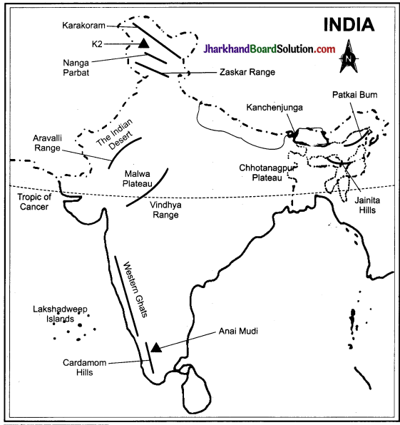
On an outline map of India, show the following:
1. Mountain and hill ranges: the Karakoram, the Zaskar, The Patkai Bum, the Jaintia, le Vindhya range, the Aravalli, and the Cardamom hills.
2. Peaks: K2, Kanchenjunga, Nanga Parbat and the Anai Mudi.
3. Plateaus: Chhota Nagpur and Malwa.
4. The Indian Desert, Western Ghats, Lakshadweep Islands.
Answer:
Locate the peaks, passes, ranges, plateaus, hills and dunes hidden in the puzzle. Try t find where these features are located. You may start your search horizontally, vertically diagonally.
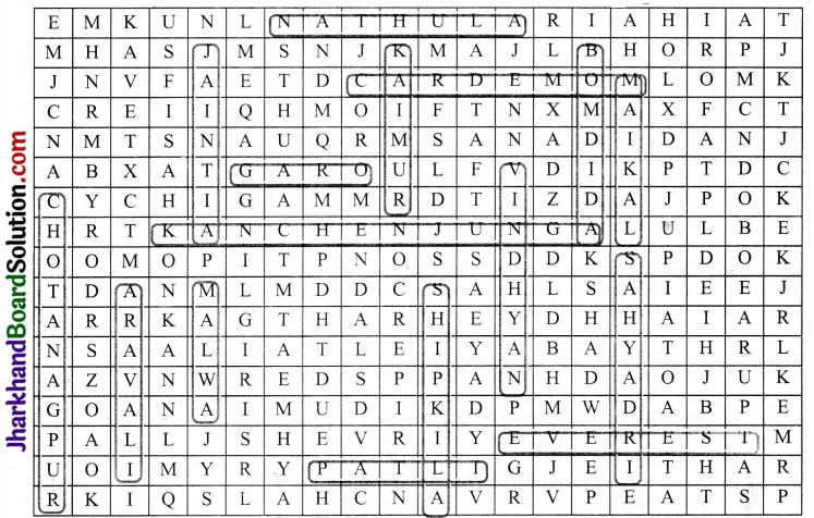
Answer:
Peaks: Kanchenjunga, Everest, Anai Mudi, Aravali
Passes: Nathu La, Shipki La, Bomdi La.
Ranges: Maikal, Sahyadri, Vindhyan.
Plateau: Chotanagpur, Malwa.
Hills: Jaintia, Kaimur, Garo, Nilgiri, Cardamom
Students can locate the above features on a map under the guidance of their teacher