JAC Board Class 9th Social Science Important Questions Geography Chapter 2 Physical Features of India
I. Objective Type Questions
1. Which of the following represents the loftiest and one of the most rugged mountain barriers of the world?
(a) Aravali range
(b) Hindukush
(c) Himalayan mountains
(d) Kunlun mountains.
Answer:
(c) Himalayan mountains
2. The Himalayan mountains form and cover a distance of:
(a) 2510 km
(b) 1750 km
(c) 2400 km
(d) 2100 km.
Answer:
(c) 2400 km
3. Which of the following parts of India is agriculturally a productive part of India:
(a) Indian desert
(b) Northern plains
(c) Peninsular plateau
(d) Coastal plains.
Answer:
(b) Northern plains
4. Which of the following in the Brahmaputra river is the largest inhabited riverine island in the world?
(a) Andamans
(b) Lakshadweep
(c) Majuli
(d) Nicobar
Answer:
(c) Majuli
5. The Indian Desert lies towards the western margins of the :
(a) Aravalli Hills
(b) Shiwalik Hills
(c) Garo Hills
(d) Jointia Hills
Answer:
(a) Aravalli Hills
II. Very Short Answer Type Questions
Question 1.
How many physiographic divisions can India be divided into?
Answer:
India can be divided into the following physiographic divisions—
- The Himalayan Mountains,
- The Northern Plains,
- The Peninsular Plateau,
- The Indian Desert,
- The Coastal Plains,
- The Islands.
Question 2.
Name the highest mountain range of the world.
Answer:
The Himalayas.
![]()
Question 3.
Write the expansion of the Himalayas.
Answer:
The Himalayas mountain ranges run in a West-East direction from the Indus to the Brahmaputra.
Question 4.
Which is the northern-most range of the Himalayas?
Answer:
The Himadri.
Question 5.
Which range of Himalayas is the most continuous range?
Answer:
The Northern-most range which is also known as Himadri or inner Himalayas is the most continuous range of Himalayas.
Question 6.
Name the most rugged range of the Himalayas.
Answer:
The Himachal.
Question 7.
Name the sub-ranges of the Himachal Himalayas.
Answer:
The sub-ranges are named as (i) Pir Panjal, (ii) Dhauladhar and (iii) Mahabharat.
Question 8.
What is the variation in height in the Shiwalik mountain range ? .
Answer:
The height of the Shiwalik mountain range varies from 900 to 1100 metres.
Question 9.
What are Shiwalik ranges made of?
Answer:
Shiwalik ranges are composed of unconsolidated sediments brought down by rivers from the main Himalayan ranges.
![]()
Question 10.
Name the longitudinal divisions of the Himalayas.
Answer:
- Punjab Himalayas,
- Kumaon Himalayas,
- Nepal Himalayas,
- Assam Himalayas.
Question 11.
By which rivers the northern-most boundary of the Himalayas formed?
Answer:
The Brahmaputra.
Question 12.
By which name are the mountains spread along the eastern boundary of India- known?
Answer:
Purvachal.
Question 13.
Name the hills running through the Purvachal.
Answer:
- Patkai,
- Naga,
- Mizo,
- Manipur Hills.
Question 14.
Name the river system that forms the northern plains.
Answer:
The Northern plains are formed by the Indus, the Ganga and the Brahmaputra river systems.
Question 15.
Which is the largest riverine island in the world?
Answer:
Majuli, in the Brahmaputra river, is the largest riverine island in the world.
![]()
Question 16.
What do you mean by the word ‘Doab’?
Answer:
‘Doab’ is made up of two words ‘do’, meaning ‘two’ and ‘ab’, meaning ‘water’. Thus, ‘Doab’ means a part between two rivers.
Question 17.
Into how many sections are the northern plains divided?
Answer:
- The Punjab Plain,
- The Ganga Plain,
- The Brahmaputra Plain.
Question 18.
What is Bhabar?
Answer:
The plains formed by the rivers, after descending from the mountains deposit pebbles in a narrow belt lying parallel to the slopes of the Shiwaliks are known as Bhabar.
Question 19.
What is Terai?
To the south of Bhabar belt, the streams and rivers re-emerge and create a wet, swampy and marshy region known as Terai.
Question 20.
The peninsular plateau can be divided into how many divisions?
Answer:
The peninsular plateau can be divided into two divisions
- The Central Highlands,
- Deccan Plateau.
Question 21.
How are the Northern Plains and Peninsular Plateau formed?
Answer:
The Northern Plains are formed by the alluvial deposits, while the Peninsular Plateau is formed by igneous and metamorphic rocks.
![]()
Question 22.
Which is the ancient landmass of India?
Answer:
Peninsular region.
Question 23.
Name the North-East extensions of the Deccan Plateau.
- Meghalaya,
- Karbi-Anglong Plateau,
- North Cachar hills.
Question 24.
Which is the highest peak in the Western Ghats?
Answer:
Anai Mudi is the highest peak in Western Ghats. Its height is 2695 metres.
Question 25.
Which is the highest peak in the Eastern Ghats?
Answer:
Mahendragiri is the highest peak in the Eastern Ghats. Its height is 1501 metres.
Question 26.
Name the hills that lie at the junction of Eastern and Western Ghats?
Answer:
The Nilgiri Hills in Tamil Nadu lie at the junction of Eastern and Western Ghats.
![]()
Question 27.
Which part of the plateau contains black soil of volcanic origin?
Answer:
The Western part of plateau known as the Deccan trap contains black soil of volcanic origin.
Question 28.
What is the Deccan Trap?
Answer:
The black soil area of the western peninsular plateau is known as Deccan Trap.
Question 29.
Where are the Aravali Hills located?
Answer:
The Aravali Hills lie on the Western and North-Western margins of the peninsular plateau.
Question 30.
Which desert is located on the western margin of the Aravali Hills?
Answer:
The Indian Desert (Thar Desert) lies towards the western margins of the Aravali Hills.
Question 31.
Which Indian coastal part is called Konkan?
Answer:
The nor’ hern part of the Indian Western Coast is known as Konkan.
Question 32.
What is the southern part of the Western Coastal Plains known as?
Answer:
The southern part of the Western Costal Plains is known as Malabar.
Question 33.
Name two sections of the eastern Coastal Strips.
- The Northern Circar,
- The Coromandel Coast.
Question 34.
Where is the Chilika Lake located? Why is it famous?
Answer:
The Chilika Lake lies in the state of Odisha, to the South of the Mahanadi delta. It is the largest salt-water lake in India.
![]()
Question 35.
By which name were the Lakshadweep islands known earlier?
Answer:
Earlier, the Lakshadweep islands were known as Laccadive, Minicoy and Amindive.
Question 36.
Where is the administrative headquarters of Lakshadeweep situated?
Answer:
Kavaratti island.
Question 37.
Where is India’s only active volcano located?
India’s only active volcano is found on Barren island in Andaman and Nicobar group of Islands.
Question 38.
What are Corals?
Answer:
Coral polyps are short-lived microscopic organisms which live in colonies in shallow, mudfree and warm water.
Question 39.
What makes up the habitat in which Coral polyps flourish?
Answer:
Coral polyps flourish in a habitat consisting of shallow warm water which does not have mud. This kind of habitat is found in Lakshadweep.
Question 40.
Where is the Great Barrier Reef located?
Answer:
Australia.
Question 41.
What are Barchans?
Answer:
Barchans are crescent-shaped dunes which cover larger area of deserts. They are found in the Indian desert, mainly in Jaisalmer and and near Indo-Pak boundary.
III. Short Answer Type Questions
Question 1.
Write any four features of the Himalayan mountains.
Answer:
Following are the four features of the Himalayan mountains:
- The Himalayas are a geologically young and structurally fold mountains.
- The Himalayas act like a natural wall to keep the fertile Indo-Gangetic plains safe from the cold winds coming from Central Asia.
- The Himalayas are source to perennial rivers like the Indus, the Ganga and the Brahmaputra.
- The Himalayas are lofty and impassable natural barriers on the Northern border of India.
Question 2.
Why are the Himalayas called young fold mountains?
Answer:
Himalayas are called young fold mountains because:
- These are young in age compared to several other mountains.
- They are made of at least three major folds or parallel ranges, e.g. Himadri, Himachal and Shiwaliks.
- They are characterised by high peaks, gorges, I-shaped valleys, glaciers and steep slopes, which indicate that the mountains are still developing.
![]()
Question 3.
Describe the Himadri.
Answer:
The Himadri or the Great or the Inner Himalayas:
- These are the Northern-most ranges of the Himalayas.
- The average elevation of the Himadri is more than 6,000 m above the sea level.
- They contain some of the world’s highest peaks, like, Mt. Everest (8,848 m) in Nepal “,nd Kanchenjunga (8,598 m) in India. Nanga Parbat (8,126 m) and Nanda Devi t ,817m) are the other two important Himalayan peaks in India.
- The G igotri and the Yamunotri glaciers which gave birth to the Ganga and the Ya mna rivers respectively are located here.
Question 4.
Describe the Middle Himalayas.
Answer:
The Himachal or the Middle Himalayas:
- Mountains lying to the South of the Himadri are known as Middle or lesser Himalayas or the Himachal.
- They have an average height of 3,700 m to 4,500 m above the sea level and extend over a width of 50 km.
- The ranges are mainly composed of highly compressed and altered rocks.
- All the important hill stations such as Dalhousie, Dharmshala, Shimla Mussoorie, Nainital and Darjeeling lie in this range.
- pir Panjal, Dhaula Dhar and Mahabharat ranges are its most important range:
Question 5.
Describe the Shiwaliks.
Answer:
The Shiwaliks or the Outer Himalayas:
- It is the Southern-most range of the Himalayas.
- The average altitude of Shiwalik-range varies between 900 m and 1,100 m above the sea level and extend over a width of 10-50 km.
- This range is made of unconsolidated material such as mud, silt, and soft rocks and is prone to earthquake and landslides.
- Some narrow valleys are found between Shiwaliks and Himachal. They are called ‘duns’. Example Dehradun.
Question 6.
Describe the divisions of the Himalayas from west to east along with Purvachal hills.
Answer:
On the basis of the location, Himalayas can be divided as follows:
1. Western Himalayas (Punjab Himalayas):
The Western section lying between the Indus and the Sutlej is known as the Punjab Himalayas. It covers a large part of Jammu and Kashmir and a part of Himachal Pradesh. They are made up of Ladakh, Zaskar and Pir Panjal ranges.
2. Central Himalayas (Kumaon Himalayas):
The section between the Sutlej and the Kali is known as Kumaon Himalayas. They extend through the state of Uttarakhand in India, and Nepal.
3. Eastern Himalayas (Nepal Himalayas):
The section between the Kali and the Teesta is known as the Nepal Himalayas.
4. Assam Himalayas (Purvachal):
The section between Teesta and Dihang (Tsang po) is known as the Assam Himalayas. They are made up of Patkai, Naga and Mizo Hills. These hills are mainly composed of strong sandstones.
![]()
Question 7.
State any three differences-between the Himadri range and Shiwalik range. The differences between Himadri and Shiwalik ranges are:
| Features | Himadri Range | Shiwalik Range |
| 1. Location | This is the Northern-most and inner most range of Himalayas. | This is the outermost range of Himalayas. |
| 2. Composition | The core of this part of Himalayas is composed of granite. | This range is composed of uncon-solidated sediment brought down by rivers from the main Himalayan ranges. |
| 3. Altitude | The average altitude of this range is 6000 metres. | The average altitude varies from 900 to 1100 metres. |
Question 8.
Make a comparison between the Himachal Himalayas and the Shiwalik based on the following:
- Composition,
- Altitude.
Answer:
The comparison between the Himachal Himalayas and the Shiwaliks on the given basis is as follows:
| Mountain Range | Composition | Altitude |
| 1. Himachal Himalayas | It is the most rugged mountain system of the Himalayas. It is composed of highly compressed and altered rocks. | It lies south of the Himadri with height varying from 3700 to 4500 metres. |
| 2. Shiwaliks | The composition of Shiwalik is of unconsolidated sediments i.e. thick gravel and alluvium brought down by the Himalayan rivers. | This is the outermost range of the Himalayas with height varying between 900 and 1100 metres. |
| Mountain Range | Composition | Altitude |
Question 9.
Describe the formation of plains.
Answer:
- To the south of the Himalayas, a basin or depression was formed.
- It was gradually filled with the alluvium brought by the rivers from north and South.
- The North Indian Plain was thus followed between the Himalayas and the Peninsular Plateau.
Question 10.
Describe three broad sections of the Northern Plains.
Answer:
1. Punjab Plains:
The Western part of the Northern Plains is referred to as the Punjab plains. It is formed by the river Indus and its tributaries. The larger part of this plain lies in Pakistan. This section of the plain is dominated by the doabs.
2. Ganga Plain:
The Ganga plain extends between Ghaggar and Teesta rivers. It spreads over the states of North India Haryana, Delhi, Uttar Pradesh and Bihar.
3. Brahmaputra Plain:
This plain lies in Assam and partly in Jharkhand and West Bengal.
![]()
Question 11.
Describe the divisions of the Northern Plains on the basis of the differences in the relief.
Or
Explain the diverse relief features of the Northen Plains.
Answer:
On the basis of the differences in the relief, the plain is divided into four sections :
1. Bhabar:
It is a narrow belt covered with pebbles lying along the foot of the Shiwaliks from the Indus to the Teesta. They are laid down by numerous streams descending down the hills. This belt is about 8 to 16 km in width.
2. Terai:
It is wet and marshy. It has a thick forest and a variety of wildlife.
3. Bhangar:
It is composed of older alluvium. It is formed higher up in the plains at river terraces. It is less fertile as compared to Khadar.
4. Khadar:
It is composed of newer alluvium. It is formed in the lower levels in the Plains near the river. It is very fertile.
Question 12.
Discuss the importance of the Northern Plains.
Answer:
The importance of the Northern Plains:
- With their fertile alluvial soils, flat surface, slow moving perennial rivers and favourable climate, the Great Plains of North India are of great economic and social significance.
- The fertile soil and ample water resources have made these plains a rich agricultural land. These plains are known as the granaries of India.
- The plains have a good network of roads and railways which has led to large scale industrialisation of the region.
- As the region has sufficient employment opportunities, so the density of population is high. More than 50% of the total population of India lives in these plains.
- The Northern plains is the site where the ancient civilization of Mohenjo da and Harappa developed
Question 13.
Write the main characteristics of the Central Highland.
Answer:
The Central Highlands of the Peninsular plateau lie to the north of the river Narmada.
- These are flanked by the Aravallis in the north-west, and consists of Malwa plateau, Bundelkhand and Baghelkhand plateau and the Chhota Nagpur plateau bound by Rajmahal Hills in the North-East. Its southern boundary is formed by the Vindhyas.
- The Central Highlands are made of hard, igneous and metamorphic rocks.
- The Central Highlands are drained by the Southern tributaries of Ganga and
Question 14.
Write a short note on‘Corals’.
Or
What are the types of corals?
Or
How are coral reefs formed? Describe the main features of the islands group which are of coral origin.
Answer:
Corals are short-lived microscopic organisms which live in colonies. They flourish in shallow, mud-free and warm waters. They secrete calcium carbonate. The coral secretion and their skeletons form coral deposits as reefs.
These roofs are mainly of three kinds:
- Barrier Reef,
- Fringing Reef,
- Atolls.
Atolls are circular or horse shoe-shaped coral reefs. In India, Lakshadweep Islands are of coral origin. They cover a small area of 32 sq. km. Karavatti is the administrative headquarters of Lakshadweep. This island group has great diversity of flora and fauna. The uninhabited Pitti island has a bird sanctuary.
IV. Long Answer Type Questions
Question 1.
Name the three longitudinal divisions of the Himalayas. Write the main features of each.
Or
Describe the major divisions of the Himalayas from North to South.
Or
Name the three parallel ranges of Himalayas. Write the major characteristics of each.
Answer:
The longitudinal divisions/parallel ranges/major divisions of the Himalayas are as follows:
1. Himadri
- The northern most range is called the Great or Inner Himalayas.
- It is the highest range with an average height of 6000 m.
- It contains all the prominent Himalayan peaks.
- The folds of Great Himalayas are assymetrical in nature. The core of this part of the Himalayas is composed of granite.
2. Himachal
- It is known as the Lesser Himalayas.
- It lies to the south of Himachal and forms the most rugges mountain system.
- The altitude varies between 3700 and 4500 metres and width is 50 km.
- This range consists of the famous valley of Kashmir and the Kangra Valley and Kullu Valley in Himanchal Pradesh.
3. Shiwaliks
- The outermost range of the Himalayas is known as the Shiwaliks.
- The Shiwaliks extend over a width of 10 to 50 km and have an altitude varying between 900 to 1100 m.
- This range is composed of unconsolidated sediments brought down by rivers from the main Himalayan ranges located further North.
- The valleys are covered with thick gravel and alluvium.
Question 2.
What are the uses of the Himalayas to India?
Answer:
Uses of the Himalayas to India: The Himalayas are beneficial for India in the following ways:
- The Himalayas are a physical wall protecting the Indian sub-continent from the rest of Asia. In the past, they stood as indestructible barriers against the aggressors from the North. This helped India to maintain its identity.
- The Himalayas act as a climatic barrier for the Indian sub-continent. They shield India from the cold, bleak winds coming from the Central Asia.
- The Himalayas also compel rain-bearing monsoon winds to shed bulk of their moisture in the Northern mountains and Northern plains.
- The Himalayas are snow-covered mountains having many glaciers also. These serve as a source of big perennnial rivers. These rivers have made the Indo-Gangetic plains very fertile. They are important for irrigation, navigation and generation of hydroelectric power.
- The Himalayas are also home to rich and varied flora and fauna. They are also a storehouse of numerous medicinal herbs.
![]()
Question 3.
Describe the Deccan Plateau.
Answer:
- The part of the Peninsular plateau extending to south of the Vindhyas is called the Deccan plateau.
- It is triangular in shape. It is at its widest in the North and goes on tapering as we move towards the South.
- The Satpura ranges and Mahadeo Hills form its northern edge.
- It is flanked by the Western Ghats in the West and the Eastern Ghats on the east.
- The Western Ghats and the Eastern Ghats meet to form Nilgiri Mountains along the border of Karnataka and Tamil Nadu.
- The North-Western part of the Deccan plateau is made up of volcanic lava and is known for its black or regur soil.
- Unlike the Western Ghats, the Eastern Ghats are discontinuous and broken by long rivers.
- This plateau is drained by east-flowing rivers – Mahanadi, Godavari, Krishna and Kaveri.
Question 4.
Write the main characteristics of the Western and Eastern Coastal Plains.
Answer:
The main characteristics of the Eastern Coastal Plains are:
- This plain is located between the Eastern Ghats and the coast of Bay of Bengal.
- It is a comparatively broader plain with a average width of around 80-100 km.
- In the Northern part, it is referred to as the Northern Gircar, while the Southern part is known as the Coromandel Coast.
- Large rivers such as the Mahanadi, the Godavari, the Krishna and the Kaveri have formed extensive deltas in this coast.
- Lake Chilika is an important feature of this coast.
- Tuticorin, Chennai, Paradweep, Vishakhapatnam are the major ports of this region.
Question 5.
Write a detailed note on the Lakshadweep and the Andaman and Nicobar islands of India.
The Island Groups of India: The Lakshadweep, and Andaman and Nicobar Islands are the main island groups of India.
The Lakshadweep Islands:
- The Lakshadweep is located 300 km west coast of Kerala in the Arabian Sea.
- The Lakshadweep Islands are a group of 36 islands.
- The Lakshadweep Islands were formerly known as Laccadive, Minicoy and Amindive Islands. They were renamed as Lakshadweep in 1973.
- The Lakshadweep is the smallest Union Territory in terms of area.
- Kavaratti Island is the headquarters of Lakshadweep Islands.
The Andaman and Nicobar Islands:
- The Andaman and Nicobar Islands group is located in the Bay of Bengal.
- The Southernmost point of India, called the Indira Point, is located in the Great Nicobar Island.
- The Andaman and Nicobar Islands consist of as many as 200 islands.
- The Nicobar group consists of 19 islands which are fairly large and more in number than the Lakshadweep Islands.
- India’s only active volcano erupted on Barren Island in the Andamans on 10th April, 1991.
The Andaman and Nicobar alongwith the Lakshadweep Islands are known for their great diversity of flora and fauna.
Question 6.
“Physiographic divisions of India are complementary to each other”. Comment the above statement.
Answer:
The Indian sub-continent consists of three structural components:
- The Great Mountain Wall of the North,
- The Northern Plains and
- The Great Peninsular Plateau.
The three geographical physical divisions of India are complementary to each other and have contributed to the growth of the Indian sub-continent as an independent economic entity. The Great Mountain Wall of the North in the form of Himalayas, has provided shelter to the sub-continent against aggression. The snow covering these lofty mountains are big reservoirs of water.
The Northern Plains are sea-level fertile plains. They are well-watered by rains and possess very good irrigation facilities. They are known as the granary of India and support a very large population of India. The Great Peninsular Plateau is the stable block. It is the storehouse of various minerals like iron ore, manganese, mica, bauxite and coal. Rice1 cotton and spices are also produced in large quantities in these regions. The partially-enclosed character of the sub-continent has helped it to evolve a culture of its own.
![]()
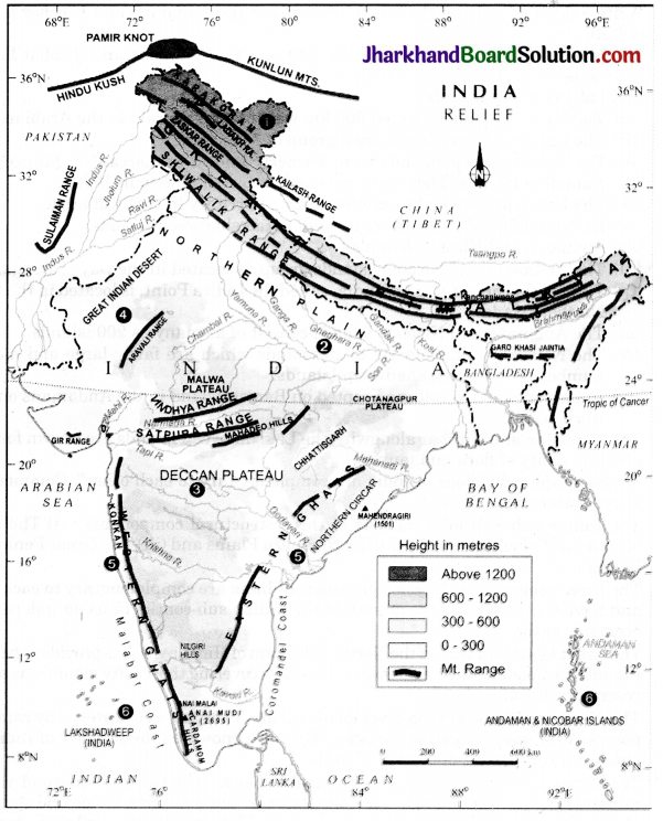
Question 1.
Physical Features of India
1. Mountain Ranges: The Karakoram, the Zaskar, the Shivalik, the Aravali, the Vindhya, the Satpura, Western & Eastern Ghats
2. Mountain Peaks: K2, Kanchanjunga, Anai Mudi
3. Coastal Plains: Konkan, Malabar, Coromandel & Northern Circar (Location & Labelling)
Answer: