JAC Board Class 9th Social Science Important Questions Geography Chapter 3 Drainage
I. Objective Type Questions
1. The river system of an area is referred to as:
(a) Water flow
(b) Drainage
(c) Delta
(d) None of these,
Answer:
(b) Drainage
2. Indian river systems can be divided into how many groups?
(a) Three
(b) Four
(c) Six
(d) Two.
Answer:
(d) Two.
3. Most of the peninsular rivers discharge their water in:
(a) Indian Ocean
(b) Bay of Bengal
(c) Arabian Sea
(d) None of these
Answer:
(b) Bay of Bengal
4. Which of the following lakes in Rajasthan is a saltwater lake?
(a) Siliserh
(b) Jaisamand
(c) Pichola
(d) Sambhar.
Answer:
(d) Sambhar.
5. The Wular lake in Jammu and Kashmir is the result of which of the following activities?
(a) Rainfall
(b) Human activity
(c) Tectonic activity
(d) None of these.
Answer:
(c) Tectonic activity
6. In which year was the Ganga Action Plan introduced?
(a) 1955
(b) 1947
(c) 1985
(d) 1995.
Answer:
(c) 1985
II. Very Short Answer Type Questions
Question 1.
What is drainage?
Answer:
The term drainage describes the river system of an area.
Question 2.
What is a drainage basin?
Answer:
The area drained by a single river system is called a drainage basin.
![]()
Question 3.
Which river has the largest river basin in the world?
Answer:
The world’s largest drainage basin is that of the Amazon river.
Question 4.
Into how many categories are the Indian rivers divided?
Answer:
The Indian rivers are divided into two major groups:
- The Himalayan rivers, and
- The Peninsular rivers.
Question 5.
Name three major rivers, which originate beyond the Himalayas.
Answer:
- Indus,
- Satluj,
- Brahmaputra river.
Question 6.
What do you understand by a river system?
Answer:
A group of a main river alongwith its tributaries is known as a river system.
Question 7.
From where the river Indus originates?
Answer:
The Indus rises in Tibet, near Lake Mansarovar.
Question 8.
What is the total length of the river Indus?
Answer:
2900 km.
Question 9.
Name the major rivers of the Indus river system.
Answer:
The Indus, the Satluj, the Jhelum, the Chenab, the Ravi and the Beas.
![]()
Question 10.
When was the Indus Water Treaty signed?
Answer:
In 1960.
Question 11.
How much percent of total Indus water can be used by India according to Indus Water Treaty?
Answer:
20 per cent.
Question 12.
Name the headwater of the Ganga.
Answer:
The Bhagirathi.
Question 13.
Where does the Bhagirathi join the Alaknanda?
Answer:
The Bhagirathi joins the Alaknanda at Devprayag in Uttarakhand.
Question 14.
Name the major tributaries of the Ganga.
Answer:
The Yamuna, the Ghaghara, the Gandak and the Kosi.
Question 15.
Which are the main tributaries of the Ganga that come from the Peninsular uplands?
Answer:
The Chambal, the Betwa and the Son.
Question 16.
Which river flows for the longest length in India?
Answer:
The Ganga river flows (2500 km) for the largest length in India.
Question 17.
Which is the northernmost point of the Ganga Delta?
Answer:
Farakka in West Bengal.
Question 18.
Name the largest delta of the world.
Answer:
Sunderban delta.
![]()
Question 19.
Which rivers form the Sunderban delta?
Answer:
The Ganga and the Brahmaputra.
Question 20.
By which name is the river Brahmaputra known in Tibet?
Answer:
Tsang Po.
Question 21.
What is the Sunderban famous for?
Answer:
Sunderban is famous for being the home of the Royal Bengal tiger.
Question 22.
Name four rivers rising in the Western Ghats.
Answer:
- Godavari,
- Krishna,
- Kaveri,
- Tungabhadra.
Question 23.
In which hills does the Narmada rise?
Or
From which place does the Narmada rises?
Answer:
The Narmada rises in the Amarkantak Hills in Madhya Pradesh.
Question 24.
Name the waterfall formed by the river Narmada.
Answer:
The Dhuadhar Falls.
Question 25.
Which is the largest river of the Peninsular India?
Or
Which river is also known as the ‘Dakshin Ganga’?
Answer:
The Godavari.
![]()
Question 26.
Name the main lagoon lakes of India.
Answer:
Chilika, Pulicat and Kolleru Lakes.
Question 28.
Which is the largest freshwater lake in India?
Answer:
The Wular lake (Jammu and Kashmir).
Question 29.
Which river s known as a perennial river?
Or
What are perennial rivers?
Answer:
perennial rivers are those which have water throughout the year.
Question 30.
The Satluj is a tributary of which river?
Answer:
The Satluj is a tributary of Indus River joining in Pakistan.
![]()
Question 31.
Where is the Sambhar Lake located? What is its use?
Sambhar Lake istuated near Jaipur in Rajasthan. Its water is used to produce salt.
Question 32.
From where does the Kaveri River originate?
Answer:
The Kaveri River originates from the Brahmagiri range of the Western Ghats.
III. Short Answer Type Questions
Question 1.
Explain the drainage system of India through a line diagram.
Answer:
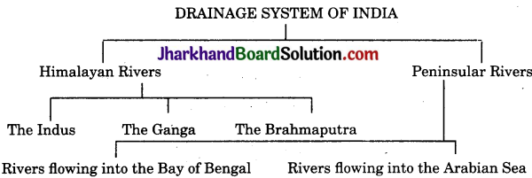
Question 2.
Mention any two features, of the Himalayan rivers.
Answer:
Two features of the Himalayan rivers are:
- The Himalayan rivers have long courses from their source to the sea.
- These rivers perform both erosional as well as depositional activities.
Question 3.
How do the Himalayan rivers perform erosional activities and form depositional features?
Answer:
- In the upper course, rivers flow with great speed from higher to lower levels, causing erosion.
- In the middle and the lower course, they carry lots of sediments like silt and sand. So, their speed slows down.
- Besides, absence of slope in the lower course causes deposition and formation of various features.
![]()
Question 4.
Mention any two features of Peninsular rivers.
Answer:
Two features of Peninsular rivers are:
- A large number of Peninsular rivers are seasonal, as their flow depends on rainfall.
- Most of the Peninsular rivers originate in the Western Ghats and flow towards the Bay of Bengal.
Question 5.
Why do most of the Peninsular rivers drain into the Bay of Bengal?
Answer:
Most of the Peninsular rivers drain into the Bay of Bengal because:
- The Eastern Ghats are lower than the Western Ghats. These are discontinuous, allowing the rivers easy passage to the Bay of Bengal.
- The Deccan plateau has a gentle slope towards the East, which gives easier passage in that direction.
Question 6.
Distinguish between a tributary and a distributary.
Answer:
Difference between a tributary and a distributary:
| Tributary | Distributary. |
| 1. When a small stream joins a larger one, the smaller stream is known as the tributary of the larger one. | 1. It is formed when a river is forced to break up into branches due to the deposition of sediments in its channel. |
| 2. It can be found in any course of a river. | 2. It is found in the lower course of a river. |
| 3. It is useful for transportation and irrigation. | 3. It provides a good network for transportation. |
| 4. Example: Yamuna is a tributary of the Ganga. | 4. Example: Padma is a distributary of the Ganga. |
Question 7.
What do you know about Indus Water Treaty?
Answer:
Indus Water Treaty is a water-sharing treaty between India and Pakistan signed on 19th September, 1960. India can use only 20 percent of the total water carried by the Indus river system. This water is used for irrigation in Punjab, Haryana and Southern and the Western parts of Rajasthan.
![]()
Question 8.
Write a note on the Tapi basin.
- The Tapi river originates from the sacred tank of Multai, in the Satpura ranges, in Betul district of Madhya Pradesh.
- It is the second-largest, west-flowing river of Peninsular India.
- The river flows in a rift valley parellel to the Narmada, but it is much shorter in length.
- The Tapi forms an estuary before falling into the Gulf of Khambhat.
- Its basin covers part of Madhya Pradesh, Gujarat and Maharashtra.
Question 9.
Write a short note on the Mahanadi basin.
- The Mahanadi has its source in the highlands of Chhattisgarh.
- The total length of the river is 860 kms.
- It covers parts of Maharashtra, Chhattisgarh, Jharkhand and Odisha.
- It drains into the Bay of Bengal.
![]()
Question 10.
Write a note on the Krishna basin.
- The Krishna river rises near Mahabaleshwar in the Western Ghats.
- It flows into the Bay of Bengal before forming a large delta.
- Its length is about 1400 km.
- The Bhima, the Tungabh ,fra, the Koyna and the Ghatprabha are its major tributanes.
- It covers Maharashtr
Question 11.
What are the major causes of river pollution?
The major causes of river pollution are as follows:
- The growing domestic, municipal, industrial and agricultural demand for water from rivers naturally affects the quality of water. As a result, more and more water is being drained out of the rivers, reducing their volume.
- A heavy load of untreated sewage and industrial effluents are emptied into the rivers. This affects not only the quality of water, but also the self cleansing capacity of the river.
- Increasing urbanisation and industrialisation is also responsible for increasing pollution level of many rivers.
Question 12.
Briefly explain the National-River Conservation Plan.
Answer:
The river cleaning programme in the country was initiated with the launching of the Ganga Action Plan in 1985. The Ganga Action Plan was expanded to cover other rivers, under the National River Conservation Plan launched in the year 1995. The objective of this programme is to improve the water quality of the rivers, which are the main water sources in the country, through the implementation of pollution control measures.
IV. Long Answer Type Questions
Question 1.
Describe the Indus river system.
- The Indus river system comprises of the Indus river and its five main tributaries The Jhelum, The Chenab, The Satluj, The Ravi and The Beas.
- The Indus originates from the glaciers of the Kailash Range in Western Tibet near Mansarovar Lake.
- It flows west and north-westwards and enters Indian territory in Ladakh.
- It flows through Ladakh, Baltistan and Gilgit and emerges from the mountains at Attock. Here, it is joined by the Kabul river from Afghanistan.
- With a total length of 2,900 kilometres, the Indus is considered as one of the longest rivers of the world.
- The sharing of water by India and Pakistan is regulated by the Indus Water Treaty signed by both the countries.
- It flows south-westwards across Pakistan to reach the Arabian Sea, east of Karachi.
![]()
Question 2.
Write a note on the Ganga river system.
Answer:
The Ganga river system includes the Ganga and its tributaries like the Yamuna, the Gomti, the Ghaghara, the Gandak, the Ramganga, the Mahaganga, the Son and the Kosi, etc.
- The Ganga rises in Garhwal Himalayas in Uttarakhand at an altitude of about 6,000 metres.
- The river acquires its name after its head-streams, Alaknanda and Bhagirathi
which unite at Devaprayag. - Flowing south-westwards, the Ganga comes out of Himalayas near Haridwar and enters the plains.
- The total length of the Ganga is 2,500 km.
- Beyond Farakka, it flows south-eastwards into Bangladesh where it is known as Padma.
- Before falling into Bay of Bengal, the Padma joins the Brahmaputra which is known as Jamuna and Meghna there. The delta formed by these rivers is known as the Sunderban delta.
Question 3.
Write the main characteristics of the Brahmaputra river system.
Answer:
- The river Brahmaputra originates from Chenayungdung glacier near Mansarovar lake in the Kailash range of the Himalayas.
- With a total length of 2900 km, it is one of the longest rivers of the world.
- Throughout the whole journey, the river passes through Tibet, India and Bangladesh. The river is known as Tsang Po in Tibet.
- Towards the end of its journey in Tibet, it takes a southwards turn near Namcha Barwa and enters Arunachal Pradesh as Dihang river. Traversing round the stairs of Garo hills, it bends southwards and enters Bangladesh near Dhubri. In Bangladesh, it is known as the Jamuna.
- At Goalundo the Jamuna joins the Ganga and is jointly known as the Padma. About 100 km further downstream, the Padma is joined by the Meghna. The river Meghna forms a very broad estuary before pouring into the Bay of Bengal.
- The Brahmaputra has a braided channel for most of its passage through Assam.
- With its tributaries like the Dihang, the Lohit, etc. discharging enormous quantities of water and silt, the river causes disastrous floods in every monsoon.
![]()
Question 4.
Explain the main features of the Narmada basin.
Answer:
The main features of the Narmada basin are as follows:
- This river originates from Amarkantak Hills in Madhya Pradesh and flows westwards through a rift valley between the Vindhya range to the North and the Satpura range to the South.
- The total length of the river from source to mouth is about 1,312 km.
- The Marble Rocks near Jabalpur where the Narmada flows through a deep gorge and the ‘Dhuadar falls’ where the river plunges over steep rocks are some of the picturesque locations formed by the Narmada.
- During much of its journey, the Narmada flows through the troughs confined by precipitous hills which do not permit any large tributaries.
- The river forms an estuary before entering the Gulf of Khambhat. There are several islands in the estuary of the Narmada.The Aliabet is the largest island of the river.
- The Narmada basin covers parts of Madhya Pradesh and Gujarat.
Question 5.
Explain the main features of the Godavari basin.
Answer:
The main features of the Godavari basin are as follows:
- The Godavari is the longest river of the Peninsula.
- It rises from the slopes of the Western Ghats in Nasik district of Maharashtra.
- It is often referred as the Vridha Ganga or the Dakshin Ganga because of its large size and extent.
- Its principal tributaries include the Parvara, the Purna, the Manjra, the Penganga, the Wainganga, the Wardha, the Pranhita, the Indravati, the Maner and the Sabari.
- Its length is about 1500 km and the river drains into the Bay of Bengal.
- The basin covers parts of Maharashtra, Madhya Pradesh, Odisha and Andhra Pradesh.
Question 6.
Write a note on the Kaveri basin.
Answer:
- The Kaveri is the most reverred and sacred river of South India.
- The source of this river lies at Talakaveri on the Brahmagiri range of hills in the Western Ghats.
- Total length of the river is about 760 km.
- It flows Eastwards and it reaches the Bay of Bengal south of Cuddalore in Tamil Nadu.
- The river is unique because it receives rainfall during summer as well as winter.
- Its main tributaries are Amravati, Bhavani, Hemavati and Kabini.
- Its basin drains parts of Karnataka, Kerala and Tamil Nadu.
![]()
Question 7.
Write a detailed note on the lakes of India.
Or
Lakes are of great value to human beings: Explain the statement with three examples.
Answer:
A lake is the depression filled with water on the Earth’s surface and is entirely surrounded by land. Even after being such a large country, India has comparatively fewer natural lakes. Following are the major types of lakes found in India:
1. Freshwater Lakes:
Most of the freshwater lakes are in the Himalayan region. They are of glacial origin. A glacier is one of the important agents of erosion. The erosive process of glaciers can create U-shaped valleys, and the irregular surface of a glaciated lowland in which water can accumulate. Dal lake, Bhimtal, Nainital, Loktak and Barapani are some of the important freshwater lakes of India.
2. Lakes of Tectonic Origin:
Folding and faulting produce hollows in the Earth’s crust. These hollows may contain either salt or fresh water. The Wular Lake in Jammu and Kashmir is the result of tectonic activity.
3. Saltwater Lake:
Any lake that has no natural drainage outlet, either as a surface stream or as a sustained sub-surface flow, will become saline. The Sambhar in the desert region of Rajasthan is a saltwater lake, and its water is used for producing salt.
4. Man-made Lakes or Artificial Lakes:
In order to harness water for generation of hydel power, to provide irrigation water to crops and to provide drinking water to urban places, a number of lakes have been constructed. Gobind Sagar and Govind Ballabh Pant Sagar are the two most important man-made lakes of India.
Importance of Lakes:
- Lakes help to regulate the flow of river. During heavy rainfall, they prevent flooding, and during the dry season, they help to maintain an even flow of water.
- Lakes can also be used for developing hydropower.
- They moderate the climate of the surroundings, maintain the aquatic ecosystem and enhance natural beauty.
- They help to develop tourism and provide recreation.
Question 8.
Describe the role of rivers in the national economy.
Or
Rivers have been of fundamental importance throughout human history. Justify the statement.
Answer:
1. Development of Civilisations:
Rivers have played a vital role in the development of civilisations. Most of the ancient civilisations like Indus, Aztec, etc. developed around the rivers. Rivers have been of fundamental importance throughout human history. The banks of the rivers have witnessed great cultural and economic progress since ancient times. Water is a basic natural resource, essential for all human activities,
2. Development of Agriculture:
Rivers and their associated alluvial soil provide the most productive agricultural lands of the country. The Ganga-Brahmaputra basin has been formed by the two great rivers. Irrigation from rivers has been the backbone of the development of Indian agriculture.
3. Settlement:
Their valleys contains dense and concentrated settlements. Most of the large cities are located on river banks. The rivers not only provide us essential water supplies, but they also receive, dilute and transport wastes from settlements.
4. Industrial Development:
Industrial development has flourished along rivers as many industrial processes rely on water as a raw material, as a coolant and for the generation of hydro electricity.
5. Means of Transportation:
Rivers provide primary channels of inland transportation, not only directly in the form of navigable waterways, but also indirectly through their valleys, where roads, railway lines and other routes are built.
![]()
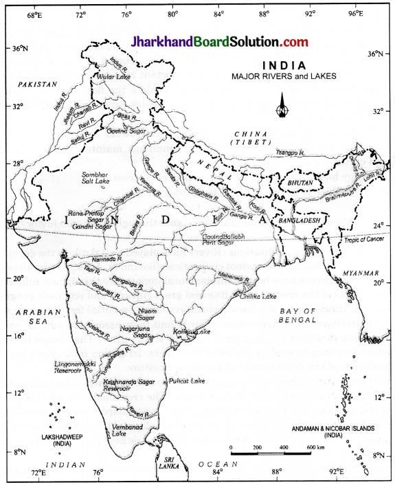
Question 1.
On an outline map of India mark the rivers and lakes of India.
Answer:
(a) The Himalayan River System: The Indus, The Ganga and The Satluj.
(b) The Peninsular River: The Narmada, The Tapi, The Kaveri, The Krishna, The Godavri, The Mahanadi
- Lakes: Wular, Pulicat, Sambhar, Chilika, Vembanad, Kolleru.
- Mountain Peaks: K2, Kanchanjunga, Anai Mudi
- Coastal Plains: Konkan, Malabar, Coromandel & Northern Circar (Location & Labelling)