JAC Class 7 Social Science Notes History Chapter 8 Devotional Paths to the Divine

JAC Board Class 7 Social Science Notes History Chapter 8 Devotional Paths to the Divine

→ From the eighth century, various kinds of Bhakti and Sufi movements have evolved.

→ The Idea of a Supreme God

  • There was a belief that social privileges came from birth in a ‘noble’ family or a ‘high’ caste was the subject of many learned texts.
  • Most of the people were not comfortable with such ideas and turned to the teachings of the Buddha or the Jainas.
  • Rest of others felt attracted to the idea of a Supreme God who could deliver humans from such bondage if approached with full devotion or bhakti. This idea was advocated in the Bhagavadgita, which grew in popularity in the early centuries of the Common Era.
  • Hence, Shiva, Vishnu and Durga were worshipped as supreme deities which came through elaborate rituals.
  • The Puranas also laid down the fact that it was possible for devotees to receive the grace of God regardless of their caste status.
  • The idea of bhakti became so popular that even Buddhists and Jainas adopted these beliefs.

JAC Class 7 Social Science Notes History Chapter 8 Devotional Paths to the Divine

→ A New Kind of Bhakti in South India – Nayanars and Alvars

  • From the seventh to ninth centuries, they saw the emergence of new religious movements
    led by the Nayanars (those were the saints devoted to Shiva) and Alvars (those were the saints devoted to Vishnu) who came from all castes including those considered as ‘untouchable’ such as the Pulaiyar and the Panars.
  • They strongly criticized the Buddhists and Jainas and preached avid love of Shiva or Vishnu as the path to salvation.
  • In the Sangam literature, the ideals of love and heroism are found. It is the earliest example of Tamil literature, composed during the early centuries of the Common Era and blended them with the values of bhakti.
  • In between the tenth and twelfth centuries, the Chola and Pandya-kings built elaborate temples. This was also the time when their poems were compiled. Apart from this, hagiographies or religious biographies of the Alvars and Nayanars were also composed.

→ Philosophy and Bhakti

  • In the eighth century, Shankara, one of the most influential philosophers of India, was born in Kerala and was an advocate of Advaita or the doctrine of the oneness of the individual soul and the Supreme God which is the Ultimate Reality. He preached renunciation of the world and adoption of the path of knowledge to understand the actual nature of Brahman and attain salvation.
  • In the eleventh century, Ramanuja was born in Tamil Nadu and deeply influenced by the Alvars. According to him, through intense devotion to Vishnu one can attain the salvation. He introduced the doctrine of Vishishtadvaita or qualified oneness in that the soul even when united with the Supreme God remained distinct.

→ Basavanna’s Virashaivism:

  • In the mid-twelfth century, the Virashaiva movement was initiated by Basavanna and his companions like Allama Prabhu and Akkamahadevi. This movement began in Karnataka.
  • They were strongly supportive for the equality of all human beings and against Brahmanical ideas about caste and the treatment of women and also against all forms of ritual and idol worship.

→ The Saints of Maharashtra

  • From the thirteenth to seventeenth centuries, Maharashtra saw many saint-poets. The most important amongst them were Dnyaneshwar (Gyaneshwar), Namdev, Eknath and Tukaram as well as women like Sakkubai and the family of Chokhamela, who belonged to the ‘untouchable’ Mahar caste.
  • These saint-poets rejected all forms of rituals. In fact, they even rejected the idea of renunciation and preferred to live with their families and earning their livelihood like any other person.
  • As the famous Gujarati saint Narsi Mehta said, “They are Vaishnavas who understand the pain of others.”
  • Hence, a new humanist idea emerged as they insisted that bhakti lay in sharing others’ pain.
  • Nathpanthis, Siddhas and Yogis
  • The Nathpanthis, Siddhacharas and Yogis were from the religious groups that emerged
    during this period and criticised the ritual and other aspects of conventional religion and the social order. They advocated renunciation of the world. For them meditation was the path to salvation.
  • They advocated intense training of the mind and body through practices likeyogasanas, breathing exercises and meditation. These groups became popular among the Tow’ castes.

→ Islam and Sufism:

  • Sufis rejected outward religiosity and emphasized on love and devotion to God and they were Muslim mystics.
  • Islam generated strict monotheism or submission to one God. It also rejected idol worship.
  • Shariat was a holy law developed by Muslim scholars. The Sufis often rejected the elaborate rituals and codes of behaviour demanded by Muslim religious scholars.
  • The Sufis too like saint poets composed poems expressing their feelings and a rich literature in prose, including anecdotes and fables, developed around them.
  • The great Sufis of Central Asia were Ghazzali, Rumi and Sadi.
  • They developed a detailed method of training using zikr means chanting of a name or sacred formula, contemplation, sama means singing, raqs means dancing, discussion of parables, breath control, etc., under the guidance of a master or pir. Thus, they emerged the silsilas means a genealogy of Sufi teachers, each following a slightly different method (tariqa) of instruction and ritual practice.
  • The most influential orders were the Chishti silsila among them. Many teachers were there such as Khwaja Muinuddin Chishti of Ajmer, Qutbuddin Bakhtiar Kaki of Delhi, Baba Farid of Punjab, Khwaja Nizamuddin Auliya of Delhi and Bandanawa Gisudaraz of Gulbarga.
  • The assemblies of the Sufi masters held in their khanqahs or hospices.
  • The tomb or dargah of a Sufi saint became a place of pilgrimage to which thousands of people of all faiths thronged and worshipped.

JAC Class 7 Social Science Notes History Chapter 8 Devotional Paths to the Divine

→ New Religious Developments in North India

  • In north India, after the thirteenth century, there was a new swing in the bhakti movement. This was the period when Islam, Brahmanical Hinduism, Sufism, various strands of bhakti, and the Nathpanths, Siddhas and Yogis influenced and transformed each other.
  • Kabir and Baba Guru Nanak rejected all conservative and devout religions. Others like Tulsidas and Surdas accepted existing beliefs and practices but wanted to make these attainable to all. Tulsidas’s composition, the Ramcharitmanas is written in Awadhi (a language used in eastern Uttar Pradesh), is important both as an expression of his devotion for Rama and as a literary work.
  • Surdas was an avid devotee of Krishna. The Sursagara, Surasaravali and Sahitya Lahari are his composition which express his devotion.
  • In late fifteenth century, Shankaradeva of Assam focused on devotion to Vishnu and composed poems and plays in Assamese. He made namghars or houses of recitation and prayer, a practice which continues till date.
  • There were some more important saints like Dadu Dayal, Ravidas and Mirabai.
  • In the sixteenth century, Mirabai who was a Rajput princess married into the royal family of Mewar. She became a disciple of Ravidas, a saint from a caste considered ‘untouchable’.
  • Most of the saints works were composed in regional languages and could be sung. They became immensely popular and were handed down orally from generation to generation.

→ A Closer Look: Kabir

  • Kabir was one of the most influential saint in the fifteenth-sixteenth century. We get to know of Kabir’s ideas from a huge collection of verses called sakhis and pads said to have been composed by him and sung by wandering bhajan singers. They were later collected and preserved in the Guru Granth Sahib, Panch Vani and Bijak.
  • His teachings were based on the rejection of the major religious traditions. The language of his poetry was understood by ordinary people as it was a form of spoken Hindi.
  • He believed in a formless Supreme God and advised that the only path to salvation was through bhakti or devotion.

→ A Closer Look: Baba Guru Nanak

  • Guru Nanak (1469-1539) bom at Talwandi (Nankana Sahib in * Pakistan) and he travelled widely before establishing a centre at Kartarpur known as Dera Baba Nanak on the river Ravi.
  • Whatever the caste, creed or gender is, his followers ate together in the common kitchen known as langar. Thus, the sacred space created by Gum Nanak was known as Dharamsala. Now it is called as Gurdwara.
  • Gum Angad who was appointed by Gum Nanak as his successor, compiled the compositions of Gum Nanak, and he added his own composition in a new script known as Gurmukhi.
  • In 1605, Gum Arjan compiled all the compositions under the name of ‘Nanak’. Other people’s writings were added to the compilation such as Shaikh Farid, Sant Kabir, Bhagat Namdev and Guru Tegh Bahadur. In 1706, this compilation was authenticated and approved by his son and successor, Gum Gobind Singh. Now, its known as Guru Granth Sahib, the holy scripture of the Sikhs.
  • By the starting of the seventeenth century, the town of Ramdaspur now Amritsar had developed around the central Gurdwara called Harmandar Sahib which is known as Golden Temple.
  • The Khalsa Panth is the community of the Sikhs which became a political entity. It was started by Gum Gobind Singh in 1699.
  • The ideas of Gum Nanak had a huge impact on the development of the Sikh movement from the very beginning. He emphasized the importance of the worship of one God. He used the terms nam, dan and isnan for the essence of his teaching, which actually meant right worship, welfare of others and purity of conduct.
  • Now his teachings are remembered as nam- japna, kirt-karna and vand-chhakna, which also mention the importance of right belief and worship, honest living, and helping others.

JAC Class 7 Social Science Notes

JAC Class 7 Social Science Notes History Chapter 7 Tribes, Nomads and Settled Communities

JAC Board Class 7 Social Science Notes History Chapter 7 Tribes, Nomads and Settled Communities

→ Society was divided according to the rules of varna in most parts of the subcontinent. These rules were prescribed by the Brahmanas and were accepted by the rulers of large kingdoms. The difference between the rich and poor increased.

→ Beyond Big Cities: Tribal Societies

  • There were other kinds of societies present as well in the subcontinent who did not follow the social rules and rituals dictated by the Brahmanas. Nor they were divided into numerous unequal classes. These types of societies are called tribes.
  • There was a distinctive bond of kinship among the members of each tribe. The main source of livelihood was agriculture but there were hunter-gatherers or herders as well. There were some tribes who were nomadic and moved from one place to another.
  • Many large tribes usually lived in forests, hills, deserts and places difficult to reach. The tribes retained their freedom and preserved their separate culture in various ways.

JAC Class 7 Social Science Notes History Chapter 7 Tribes, Nomads and Settled Communities

→ Who were Tribal People?

  • Tribal people did not keep written records but they preserved rich customs and oral traditions. And these were passed down to each new’ generation.
  • Some powerful tribes controlled large territories as people were found in almost every region of the subcontinent.
  • The Khokhar tribe in Punjab was very influential and powerful during the thirteenth and fourteenth centuries. Later, the Gakkhars became more important. Kamal Khan Gakkhar, the chief was made mansabdar by Emperor Akbar.
  • The Langahs and Arghuns in Multan and Sind, dominated extensive regions before they were subdued by the Mughals.
  • The Balochis were another large and powerful tribe in the north-west.
  • The shepherd tribe of Gaddis lived in the western Himalaya.
  • The Nagas, Ahoms and many others too dominated the north-eastern part of the subcontinent.
  • Chero chiefdoms had emerged by the twelfth century in Bihar and Jharkhand. Akbar’s famous general Raja Man Singh attacked and defeated the Cheros in 1591.
  • The Mundas and Santals were among the other important tribes that lived in Jharkhand, Bihar, Orissa (now Odisha) and Bengal.
  • The Kolis, Berads and numerous other tribes were found in Maharashtra, Gujarat and Karnataka.
  • Far away south there were large tribal populations of Koragas, Vetars, Maravars and many others.
  • The tribe of Bhils were spread across western and central India.
  • Another tribe, the Gonds were found in good numbers across the present-day states of Chhattisgarh, Madhya Pradesh, Maharashtra and Andhra Pradesh.

→ How Nomads and Mobile People Lived?

  • Nomads who lived on milk and other pastoral products and moved over long distances with their animals are called nomadic pastoralists. They also exchanged wool, ghee, etc., with settled agriculturists for grain, cloth, utensils and other products.
  • The most important trader nomads were the Banjaras. Their caravan was called tanda.
  • To transport grain to the city markets, Sultan Alauddin Khalji used the Banjaras.

→ Changing Society: New Castes and Hierarchies

  • As the society grew, people with new skills were required hence, smaller castes, or jatis, emerged within varnas.
  • Artisans such as smiths, carpenters and masons were also recognised as separate jatis by the Brahmanas. Jatis became the basis for organising society rather than varna.
  • New Rajput clans, the Kshatriyas became powerful by the eleventh and twelfth centuries. They belonged to different lineages such as Hunas, Chandelas, Chalukyas and some others. Among them, some had been tribes earlier. They moderately replaced the older rulers especially in agricultural areas.
  • The tribal people had to follow the Rajput clans to the position of rulers as they set an example for them.

→ A Closer Look The Gonds

  • The Gonds practised shifting cultivation as they lived in a vast forested region called Gondwana or “country inhabited by Gonds”.
  • The Akbar Nama reveals the Gond kingdom of Garha Katanga that had 70,000 villages.
  • The kingdom was divided into garbs and each was controlled by a particular Gond clan. It was further divided into units of 84 villages called chaurasi. The chaurasi was again subdivided into barhots which were made up of 12 villages each.
  • The Gond raja of Garha Katanga Aman Das, assumed the title of Sangram Shah. His son, Dalpat, married princess Durgawati, the daughter of Salbahan, the Chandel Rajput raja of Mahoba.
  • She was very capable and brave and started ruling on behalf of her five-year old son, Bir Narain. In 1565, she was defeated by the Mughal forces under Asaf Khan and preferred to die than to surrender. Her son also died fighting after sometime.

JAC Class 7 Social Science Notes History Chapter 7 Tribes, Nomads and Settled Communities

→ The Ahoms

  • In the thirteenth century, the Ahoms migrated to the Brahmaputra valley from present-day Myanmar. They created a new system of the bhuiyans means landlords.
  • They used firearms in 1530s and by that the Ahoms built a large state. They could even make high quality gunpowder and cannons by the 1660s.
  • In 1662, the Mughals under Mir Jumla attacked the Ahom kingdom but they were defeated.
  • The state depended upon forced labour. Those who were forced to work for the state were called paiks.
    The new methods of rice cultivation was also introduced by Ahoms.
  • The society was divided into clans or khels. A khel often controlled several villages.
  • The Ahoms worshipped their own tribal gods. During the reign of Sib Singh (1714-1744), Hinduism became the predominant religion. But they did not completely give up their traditional beliefs after adopting Hinduism.
  • The historical works known as buranjis were written first in the Ahom language and then in Assamese. It was a very sophisticated society. Theatre was encouraged a lot.

→ Conclusion:
This period saw more interaction between varna based society and the tribal groups. Few established extensive states with well- organised systems of administration hence, became politically powerful.

JAC Class 7 Social Science Notes

JAC Class 7 Social Science Solutions History Chapter 6 Towns, Traders and Craftspersons

JAC Board Class 7th Social Science Solutions History Chapter 6 Towns, Traders and Craftspersons

JAC Class 7th History Towns, Traders and Craftspersons InText Questions and Answers

Page 75

Question 1.
What would a traveller visiting a medieval town expect to find?
Answer:
A traveller visiting a medieval town is expected to find out what type of a town it is temple town, administrative centre, commercial town or a port town, etc.

Page 76

Question 2.
Why do you think people regarded Thanjavur as a great town?
Answer:
People regarded Thanjavur as a great town because of the following reasons: It was the capital of Chola empire which was a temple town with Rajarajeshvara temple in it. It also gave employment to a large number of people hence becoming a centre of opportunities. It had a big market selling food, cloth, jewellery, etc.

JAC Class 7 Social Science Solutions History Chapter 6 Towns, Traders and Craftspersons

Page 77

Question 3.
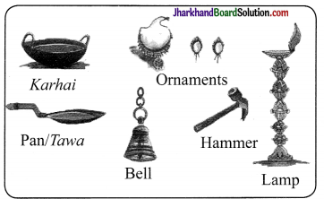
What do you think were the advantages of using Bronze, bell metal and the “lost wax” technique?
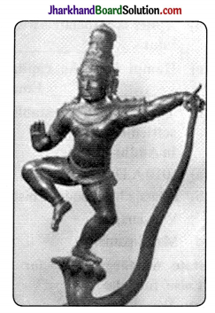
JAC Class 7 Social Science Solutions History Chapter 6 Towns, Traders and Craftspersons 1
Answer:
The Tost wax’ technique had the following advantages:

  • Wax was a reusable material and a quick way to make statues of any shape.
  • When the metal were cooled and solidified, the clay cover was removed. The Bronze statues were not at all hollow from inside and had long life. The Bronze statues were not at all hollow from inside. They were solidified and had long life.

Page 78

Question 4.
Make a list of towns in your district and try to classify these as administrative centres or as temple/pilgrim centres.
Answer:
Need to do it yourself. Hint: Can take help from parents and subject teacher.

Page 79

Question 5.
Find out more about present-day taxes on markets: who collects these, how are they collected and what are they used for.
Answer:
Present-day taxes on markets:

  • They are the property tax, service tax, etc.
  • Central or State government collect these taxes through revenue departments. This department works with other departments to collect and use the money.
  • They are collected in cash.
  • The money collected is used for welfare and development of the society. Moreover, these taxes help in infrastructure development of the nation.

Page 80

Question 6.
As you can see, during this period there was a great circulation of people and goods. What impact do you think this would have had on the lives of people in towns and villages? Make a list of artisans living in towns.

During this period, the great circulation of people and goods must had have following impacts on the lives of people living in towns and villages:

  • They would have become busier and engaged than ever before and their incomes must have increased.
  • Their time must have reduced for the family as they would have started giving more time to the commercial activities.

List of artisans living in towns were:

  • Blacksmith
  • Weavers
  • Metal worker
  • Potters
  • Brass dealers
  • Goldsmith
  • Wood carver
  • Gardener
  • Tailors

Page 83

Question 7.
Why do you think the city was fortified?
Answer:
Hampi was a trade as well as temple town. And temples, were the centres of wealth and the honour of kings. In order to protect the people from the attack of the enemy, the town of Hampi was fortified.

Page 85

Why did the English and the Dutch decide to establish settlements in Masulipatnam?
The English and the Dutch decided to establish settlements in Masulipatnam because Masulipatnam was the most important port of the Andhra coast. It had the convenience of the place where ship can anchor. It was the trade town connected to the hinterland. Due to all such reasons, the Dutch and the English decide to establish settlements in Masulipatnam.

JAC Class 7 Social Science Solutions History Chapter 6 Towns, Traders and Craftspersons

Page 88

Question 9.
Imagine, you are planning a journey from Surat to West Asia in the seventeenth century. What are the arrangements you will make?
Answer:
If I would plan a journey from Surat to West Asia in the 17th century. I would make the following arrangements:

  1. I would get a confirmed reservation in one of the ships travelling on the route.
  2. I would send some money to West Asia through hundi, as it would not be wise to carry money on a ship journey.
  3. I would look for if I could do some businesses on my journey.

JAC Class 7th History Towns, Traders and Craftspersons Textbook Questions and Answers

Question 1.
Fill in the blanks:
(a) The Raj arajeshvara temple was built in……..
(b) Ajmer is associated with the Sufi saint…… .
(c) Hampi was the capital of the………. Empire.
(d) The Dutch established a settlement at…… in Andhra Pradesh.
Answer:
(a) 1010 A.D.
(b) Khwaja Muinuddin Chisti
(c) Vijayanagara
(d) Masulipatnam

Question 2.
State whether ‘True’ for true and ‘False’ for false.
(a) We know the name of the architect of the Rajarajeshvara temple from an inscription.
(b) Merchants preferred to travel individually rather than in caravans.
(c) Kabul was a major centre of trade for elephants.
(d) Surat was an important trading port on the Bay of Bengal.
Answer:
(a) True
(b) False
(c) False
(d) False

Question 3.
How was water supplied to the city of Thanjavur?
Answer:
Thanjavur was situated near the pemninal river Kaveri. It was from this river that was water supplied to the city. Water supplied to the city of Thanjavur came from tanks and wells.

Question 4.
Who lived in the “Black Towns” in cities such as Madras (now Chennai)?
Answer:
During the eighteenth century, the cities such as Bombay, Calcutta and Madras were formed. During this period, the crafts and commerce underwent major changes as merchants and artisans (such as weavers) were moved into the ‘Black Towns’ established by the European companies within these new cities. The ‘blacks’ or native traders and crafitspersons were confined here while the ‘white’ rulers occupied superior residencies of Fort St. George in Madras or Fort St. William in Calcutta.

(Let’s Understand)

Question 5.
Why do you think towns grew around temples?
Answer:
Towns grew around temples because the temple towns represented a very important pattern of urbanisation. Temples were considered central to the economy and society. The following reasons are:

  • A large number of people like priests, workers, artisans, traders, etc., settle near the temples to cater its needs.
  • Temples were mostly the central hub to the economy and society.
  • Rulers built temples, donated land and money to carry out elaborate rituals, feed pilgrims and priests and celebrate festivals.
  • Pilgrims also made donations to the temples.
  • Temple authorities used their wealth to finance, trade and banking.

Question 6.
How important were craftspersons for the building and maintenance of temples?
Answer:
The Panchalas or Vishwakarma community consisting of goldsmiths, bronzesmiths, blacksmiths, masons and carpenters. The community played an essential role in the building of temples. They had an important role in the construction of big buildings, palaces, tanks and reservoirs. They executed the following activities:

1. The craftspersons of Bidar were well known for their inlay work in copper and silver and it was known as Bidri.

2. During the eighteenth century, the cities such as Bombay, Calcutta and Madras were formed. During this period, the crafts and commerce underwent major changes as merchants and artisans (such as weavers) were moved into the ‘Black Towns’ established by the European companies within these new cities. The ‘blacks’ or native traders and craftspersons were confined here while the ‘white’ rulers occupied superior residencies of Fort St. George in Madras or Fort St. William in Calcutta.

3. Weavers like Saliyar and Kaikkolars were very prosperous communities and they often donated money to temples.

Question 7.
Why did people from distant lands visit Surat?
Answer:
Surat was a cosmopolitan city and people of all castes and creeds lived there. People from distant lands visited Surat for the following reasons:

  • Surat was one of the most important medieval ports on the west coast of Indian subcontinent.
  • The Portuguese, Dutch and English had their factories and warehouses at Surat during the seventeenth century.
  • Surat was gateway for trade with West Asia via the Gulf of Ormuz.
  • It has also been called the gateway to Mecca, because many pilgrims’ ship set sail from here.
  • The big market for cotton textiles was present. There were also several retail and wholesale shops selling cotton textiles.
  • Surat was also famous for the textiles with gold lace borders (zari) which had a market in West Asia, Europe and Africa.
  • The Kathiawad seths or mahajans (moneychangers) had huge banking houses at Surat. Also, the Surat hundis were honoured in the far-off markets of Cairo in Egypt, Basra in Iraq and Antwerp in Belgium.
  • Magnificent buildings and pleasure parks also attracted people from far- off places. They had ample of rest houses for visitors and traders.

Question 8.
In what ways was craft production in cities like Calcutta different from that in cities like Thanjavur?
Answer:

Craft production in CalcuttaCraft production in Thanjavur
It was in the form of cotton, jute and silk textiles.It was oganised and planned by the European companies.
They had to produce whatever was demanded by the European companies.It was in the form of inlay work in metals such as copper and silver.
The production mainly focused on the needs of the temple and the pilgrims.They were free to be as much creative as they could be.

(Let’s Discuss)

Question 9.
Compare any one of the cities described in this chapter with a town or a village with which you are familiar. Do you notice any similarities or differences?
Answer:
Do it yourself. Hint: Take the present-day of New Delhi

  • Similarities
  • Mention about Parliament and about Justice means Supreme Court.
  • Many people from distant places visit here and many traders and powerful people live here.
  • It is cultural and economic development centre. Also provides employment opportunities, etc.
  • Differences-(with Thanjavur)
  • Much larger area and had an elaborate transportation system.
  • It also experiences unlawful activities.
  • Migrants come everyday in search of work to Delhi, etc.

Question 10.
What were the problems encountered by merchants? Do you think some of these problems persist today?
Answer:
The problems encountered by the merchants were:

  • Merchants travelled in caravans carrying goods on the back of horses and camels. They had to travel through forests and there was always the fear of robbers.
  • But the European Companies’ used their naval power to gain control
    of the sea trade and forced Indian traders to work as their agents.
  • In the market also, they had to face tough competition with European traders.
  • Yes, some problem still persists today.

(Ie?sDo)

Question 11.
Find out more about the architecture of either Thanjavur or Hampi, and prepare a scrap book illustrating temples and other buildings from these cities.
Answer:
Do it yourself. Hint: Can take help from sources like books, articles, internet, etc.

JAC Class 7 Social Science Solutions History Chapter 6 Towns, Traders and Craftspersons

Question 12.
Find out about any present-day pilgrimage centre. Why do you think people go there? What do they do there? Are there any shops in the area? If so, what is bought and sold there?
Answer:
Do it yourself.
Hint: Present day pilgrimage centre: Tirupati. People go to this place and do worship and follow certain rituals. They go to famous Balaji temple. There are many shops and hotels. People visit and stay for few days. Offering materials are . also sold in these shops.

JAC Class 7th History Towns, Traders and Craftspersons Important Questions and Answers

Multiple Choice Questions

Question 1.
Thanjavur served as the capital under the reign of……. rulers.
(a) Shakya
(b) Mughal
(c) Chola
(d) Chauhan
Answer:
(c) Chola

Question 2.
Mandapas or pavilions were used for
(a) training soldiers
(b) assembly meetings and carrying out administrative works and issuing orders
(c) imparting knowledge of art and craft to women
(d) None of the above
Answer:
(b) assembly meetings and carrying out administrative works and issuing orders

Question 3.
A holy lake named Pushkar is situated near which city?
(a) Ajmer
(b) Jaipur
(c) Udaipur
(d) Bikaner
Answer:
(a) Ajmer

JAC Class 7 Social Science Solutions History Chapter 6 Towns, Traders and Craftspersons

Question 4.
The built the fort of Masulipatnam.
(a) Portuguese
(b) French
(c) English
(d) Dutch
Answer:
(d) Dutch

Question 5.
Group of muslim merchants are known as…….
(a) Noors
(b) Moors
(c) Hoors
(d) None of these
Answer:
(b) Moors

Question 6.
Surat is located on
(a) the banks of the river Ganga
(b) the banks of the river Tapti
(c) the banks pf the river Jhelum
(d) the banks of the river Yamuna
Answer:
(b) the banks of the river Tapti

Question 7.
Domingo Paes was
(a) an Arab traveller
(b) a French traveller
(c) a Portuguese traveller
(d) a Spanish traveller
Answer:
(c) a Portuguese traveller

Question 8.
Great Indian traders such as ….. and ….owned a large number of ships which competed with East India Companies.
(a) Mulla Abdul Ghafur, Virji Vora
(b) Mir Zafar, Mir Jumla
(c) Mulla Abdul Ghafur, Mir Zafar
(d) None of these
Answer:
(a) Mulla Abdul Ghafur, Virji Vora

Question 9.
The Rajarajeshvara temple was located in……
(a) Bijapur
(b) Thanjavur
(c) Hampi
(d) Masulipatnam
Answer:
(b) Thanjavur

Question 10.
Which city was known as Gateway of Asia?
(a) Hampi
(b) Calcutta
(c) Bombay
(d) Surat
Answer:
(d) Surat

Very Short Answer Type Questions

Question 1.
Which type of sculpture is famous from Thanjavur?
Answer:
Bronze idols are famous from Thanjavur.

Question 2.
Why do you think the temples become so important and powerful in medieval India?
Answer:
The temples became so important and powerful in medieval India because rulers gave a lot of money and grant land for temple development.

Question 3.
Write names of two famous guilds of the 8th century from the southern part of India.
Answer:
Manigramam and Nanadesi are the two famous guilds of the 8th century from the southern part of India.

Question 4.
Give an example of a temple town.
Answer:
Thanjavur was a temple town.

JAC Class 7 Social Science Solutions History Chapter 6 Towns, Traders and Craftspersons

Question 5.
European gain control of the sea route. How did they do that?
Answer:
European gain control of the sea route as they used their naval power to get authority of the sea trade.

Question 6.
What do you mean by emporium?
Answer:
A plage where goods from diverse production centres are bought and sold is called emporium. Such as, Surat was the emporium of Western trade.

Question 7.
India did trade with Africa. What did they brought?
Answer:
India did trade with Africa. They brought ivory and gold.

Question 8.
Which spices became the part of European cooking?
Answer:
Spices which were grown in tropical climates such as pepper, cinnamon, nutmeg, dried ginger, etc., became an important part of European cooking.

Question 9.
From which place did the Gujarati traders imported spices, tin, Chinese blue pottery and silver?
Answer:
From Southeast Asia and China, Gujarati traders imported spices, tin, Chinese blue pottery and silver.

Question 10.
Name some important temple towns.
Answer:
Some important temple towns are Thanjavur, Bhillasvamin in Madhya Pradesh, Somnath in Gujarat, Kanchipuram, Madurai in Tamil Nadu and Tirupati in Andhra Pradesh.

Short Answer Type Questions

Question 1.
Which ruler tried to play off Dutch and English against each other and why?
Answer:
Since the Mughals began to extend their power to Golconda, their representative the governor Mir Jumla who was also a merchant, began to play off the Dutch and the English against each other.

Question 2.
What do you mean by hundi? Who used hundi and in which city it was used?
Answer:
Hundi is a note recording and a deposit made by a person. The amount deposited can be claimed in another place by presenting the record of the deposit. The Kathiawad seths or mahajans (moneychangers) had huge banking houses at Surat. In Surat, hundis were honoured in the far-off markets of Cairo in Egypt, Basra in Iraq and Antwerp in Belgium.

Question 3.
Which type of markets did the small towns had?
Answer:
Small towns usually had a mandapika (or mandi of later times) to which nearby villagers brought their produce and things to sell. They also had market streets called hatta (haat of later times) lined with shops. Also, there were streets for different kinds of artisans such as potters, oil pressers, sugar makers, toddy makers, smiths, stonemasons, etc.

JAC Class 7 Social Science Solutions History Chapter 6 Towns, Traders and Craftspersons

Question 4.
Give reasons for the decline of Surat.
Answer:
Surat began to decline towards the end of the seventeenth century because of the following reasons:

  • Due to the decline of the Mughal Empire there was the loss of markets and productivity.
  • The sea routes were controlled by the Portuguese and competition from the English East India Company which shifted its headquarters to

Question 5.
The most impressive community was the Vora community. Discuss.
Answer:
In India, the trading communities were quite large in number and assimilated some of the richest merchants and traders in the world. Virji Vora who dominated Gujarat trade for several decades had a large fleet of ships. Mulla Abdul Ghafur was one of the noteworthy big merchants.

Question 6.
Name the main centres of cotton manufacturing.
Answer:
The main centres of cotton manufacturing were Patna, Cambay and Ahmedabad, Burhanpur, Bengal, Kashmir, Lahore and United Provinces.

Question 7.
Which trading groups made the city, Masulipatnam populous and prosperous?
Answer:
The trading groups which made the city of Masulipatnam populous and prosperous were the Golconda nobles, Persian merchants, Telugu Komati Chettis and European traders.

Question 8.
If weavers wanted to sign deals with the East India Company, they couldn’t sell their own cloth or weave their own patterns. Why?
Answer:
If weavers wanted to sign deals with the East India Company, they couldn’t sell their own cloth or weave their own patterns because they had to work on a system of payments in advance which meant that they had to weave cloth which was already promised to European agents.

JAC Class 7 Social Science Solutions History Chapter 6 Towns, Traders and Craftspersons

Question 9.
Write any three distinct type of urban centres in the medieval period.
Answer:
The three distinct types of urban centres in the medieval period were:

  • Administrative towns Delhi, Agra, Lahore, etc.
  • Commercial and manufacturing towns Daulatabad, Patna, Ahmedabad, Muziris, Surat, Hampi, Masulipatnam, etc.
  • Pilgrim towns Banaras, Kanchipuram, Mathura, etc.

Question 10.
Briefly explain the Mughal Karkhanas.
Answer:
The karkhanaa in the Mughal period were known as Buyutat as well. It was used for both storing and manufacturing articles for the royal household and nobles requirements. Following sections come under the karkhanas, such as public treasury, department of construction of monuments, repairing, roads and artillery.

Long Answer Type Questions

Question 1.
Explain the different ventures and occupations of big and small traders
in the medieval period.
Answer:
The different ventures and occupations of big and small traders in the medieval period were:

  • Many types of traders were there. It included Banjaras and various traders especially horse traders. ‘ They formed associations with headmen with warriors who bought horses.
  • Caravans were usually used by traders to travel and formed guilds to protect their interests.
  • Communities were present such as Marwari Oswals and Chettiars who later become the main trading groups of the country.
  • Gujarati traders which include the communities of Hindu Baniyas and Muslim Bohras traded enormously with the ports of Red Sea, Persian Gulf, East Africa, China and South East Asia.
  • They majorly sold textiles and spices in these towns and in return brought ivory and gold from Africa and silver, tin, spices, Chinese blue pottery from China and South East Asia.
  • Many traders such as Persian, Chinese, Arab, Syrian Christian, Jewish traded in the towns on the west coast.
  • Indian spices and cotton cloth became the source of attraction for the European traders. And, eventually reached the European markets fetching high profits.

Question 2.
Hampi was in its peak time in the 16th centuries. How? When did it fall to ruin?
Answer:
Hampi was in its peak time in the fifteenth and sixteenth centuries because:

  • It was a very important centre for commercial and cultural activities.
  • Moors which means a name used collectively for Muslim merchants, Chettis and agents of European traders such as the Portuguese, visited the markets of Hampi for different trades.
  • Temples were the main focal point of cultural activities and devadasis means temple dancers performed different forms of dances before the deity, royalty and masses in the many-pillared halls in the Virupaksha which is a form of Shiva temple.
  • The Mahanavami festival which is known today as Navaratri was one of the most important festivals celebrated at Hampi.
  • During the Mahanavami platform, the king received guests and accepted tribute from subordinate chiefs. From here he also watched dance and music performances which held during the festival time as well as wrestling bouts.
  • By the defeat of Vijayanagara in 1565 by the Deccani Sultans which were the rulers of Golconda, Bijapur, Ahmadnagar, Berar and Bidar, Hampi fell into ruin.

JAC Class 7 Social Science Solutions

GLENMARK Pivot Calculator
JAC Class 7 Social Science Solutions History Chapter 10 Eighteenth Century Political Formations

JAC Board Class 7th Social Science Solutions History Chapter 10 Eighteenth Century Political Formations

JAC Class 7th History Eighteenth Century Political Formations InText Questions and Answers

Page 139

Question 1.
See Chapter 4, Table 1. Which group of people challenged Mughal authority for the longest time in Aurangzeb’s reign?
Answer:
The Marathas under the leadership of Shivaji challenged Mughal authority for the longest time in Aurangzeb’s reign.

Page 144

Question 2.
In trying to consolidate their rule, why did Mughal subadars also want to control the office of diwan?
Answer:
In trying to consolidate their rule, Mughal subadars also want to control the office of diwan because they were very ambitious, aspiring and power hungry and diwan office was the main point.

JAC Class 7 Social Science Solutions History Chapter 10 Eighteenth Century Political Formations

Page 148

Question 3.
What is the Khalsa? Do you recall reading about it in Chapter 8?
Answer:
Guru Gobind Singh in the seventeenth century, organised group of warriors known as Khalsa and requested the presence of the institution of Sikhs. Five persons were chosen called as Panj Pyare who took the water of immorality. There are five features which distinguish Sikhs from others.,which are known as 5Ks. These are Kesh (hair), Kara (iron bracelet), Kangha (comb), Kripan (dagger) and Kacchera (underwear).

Page 152

Question 4.
Imagine, you are a ruler of an eighteenth century kingdom. Tell us about the steps you would take to make your position strong in your province, and what opposition or problems you might face while doing so.
Answer:
In order to make my position strong, I would reform military and financial systems of my province. I would end corruption in the administration. The most expected problem would be the attack of some other kingdom. I would be ready to face any such attack.

JAC Class 7th History Eighteenth Century Political Formations Textbook Questions and Answers

Question 1.
Match the following:

subadara revenue farmer
faujdara high noble
ijaradarprovincial governor
mislMaratha peasant warriors
chautha Mughal military commander
kunbisa band of Sikh warriors
umaratax levied by the Marathas

Answer:

subadarprovincial governor
faujdara Mughal military commander
ijaradara revenue farmer
misla band of Sikh warriors
chauthtax levied by the Marathas
kunbisMaratha peasant warriors
umaraa high noble

Fill in the blanks:

Question 2.
(a) Aurangzeb fought a protracted war in the ………..
(b) Umara and jagirdars constituted powerful sections of the Mughal ………..
(c) Asaf Jah Founded the Hyderabad state in ………..
(d) The founder of the Awadh state was …………
Answer:
(a) Aurangzeb fought a protracted war in the Deccan
(b) Umara and jagirdars constituted powerful sections of the Mughal administration
(c) Asaf Jah Founded the Hyderabad state in 1724
(d) The founder of the Awadh state was Burhan-ul-Mulk Sa’adat Khan

Question 3.
State ’T’ for true and ’F’ for false.
(a) Nadir Shah invaded Bengal.
(b) Sawai Raja Jai Singh was the ruler of Indore.
(c) Guru Gobind Singh was the tenth Guru of the Sikhs.
(d) Poona became the capital of the Marathas in the eighteenth century.
Answer:
(a) False
(b) False
(c) True
(d) True

JAC Class 7 Social Science Solutions History Chapter 10 Eighteenth Century Political Formations

Question 4.
What were the offices held by Saadat Khan?
Answer:
Sa’adat Khan held the integrated offices of subadari, diwani and faujdari. Actually, he was responsible for managing the political, financial and military affairs of the province of Awadh.

(Let’s Discuss)

Question 5.
Why did the Nawabs of Awadh and Bengal try to do away with the jagirdari system?
Answer:
The Nawabs of Awadh and Bengal tried to do away with the jagirdari system to decrease Mughal influence in the regions by reducing the number of officeholders (jagirdars) appointed by the Mughals. They also reduced the size of jagirs, and appointed his own loyal servants to vacant positions. The accounts of jagirdars were checked to prevent cheating and the revenues of all districts were reassessed by officials appointed by the Naw’ab’s court. In an effort to reduce the Mughal influence in Bengal, Murshid Question uli Khan transferred all Mughal jagirdars to Orissa and ordered a major reassessment of the revenues of Bengal. Revenue was collected in cash with great strictness from all zamindars. As a result, many zamindars had to borrow money from bankers and moneylenders.

Question 6.
How were the Sikhs organised in the eighteenth century?
Answer:
The Sikhs were organised in the eighteenth century in the following way:

  • They organised themselves into a number of bands known as jathas and later on mis Is.
  • They had a combined forces which was known as dal Khalsa or grand army.
  • In Amritsar during Baisakhi and Diwali, the whole body of people used to meet to take collective decisions called as the ‘resolutions of the Guru (gurmatas).’
  • Guru Gobind Singh organised
    the army with the influence and inspiration that their destiny was to rule.
  • The well knit Sikh organisation, put a strong resistance on Mughal governors first, then to Ahmad Shah Abdali who had captured the strong province of Punjab and siezed Sarkar of Sirhind from the Mughals.
  • The Sikh territories in the late eighteenth century extended from the Indus to the Jamuna, but they were divided under different rulers.
  • One of them, Maharaja Ranjit Singh, reunited these groups and established his capital at Lahore in 1799.

Question 7.
Why did the Marathas want to expand beyond the Deccan?
Answer:
The Marathas wanted to expand beyond the Deccan to challenge and decrease the Mughal influence. By the 1720s, they seized Malwa and Gujarat from the Mughals and by 1730s, they were recognised as the overlord of the entire Deccan.

Question 8.
What were the policies adopted by Asaf Jah to strengthen his position?
Answer:
The policies adopted by Asaf Jah to strengthen his position were:

  • He brought trained and skilled soldiers and administrators from northern India who wanted to explore the new opportunities in the south.
  • He recruited mansabdars and granted jagirs to them.
  • Without Mughal interference, he ruled independently. The Mughals rarely confirm the decisions that were taken by Asaf Jah.

Question 9.
Do you think merchants and bankers today have the kind of influence they had in the eighteenth century?
Answer:
Merchants were more influential and powerful than the bankers in the eighteenth century than today. Banks were not so organised and merchants used to provide more loan opportunities at higher rates of interests. Nowadays, banks are more influential. They provide financial assistance and loans at lower rates and act as a shield of protection of public money. They also provide subsidy on lower rates. This happened due to the spread of education.

JAC Class 7 Social Science Solutions History Chapter 10 Eighteenth Century Political Formations

Question 10.
Did any of the kingdoms mentioned in this chapter develop in your state? If so, in what ways do you think life in the state would have been different in the eighteenth century from what it is in the twenty first century?
Answer:
Students need to do by their own as if they stay in any of the region where any kingdom developed.
Hint: If we take up Punjab as the region then there developed many states in the eighteenth century, the East India Company started capturing the regions and other rulers were present. But, in twenty first century, we are a democratic country.

(Let’s Do)

Question 11.
Find out more about the architecture and culture associated with the new courts of any of the following Awadh, Bengal or Hyderabad.
Answer:
The architecture and culture associated with the new courts of any one of the following:

  • The rulers of Awadh does not discriminate between the Muslims and Hindus. They had a very secular political policies.
  • Temples and mosques were constructed.
  • Lucknow became the cultural city due to the economic prosperity and peace in the state. Lucknow was an important city of Awadh. It also developed as an important centre of art and craft.
  • Students can also mention about Hyderabad and Bengal with the help of parents and teachers.

Question 12.
Collect popular tales about rulers from any one of the following groups of people: the Rajputs, Jats, Sikhs or Marathas.
Answer:
Students need to do it at their own.
(Hint : Can take inputs from various sources such as internet, books, journals and teachers.)

JAC Class 7th History Eighteenth Century Political Formations Important Questions and Answers

Multiple Choice Questions

Question 1.
Ahmad Shah Abdali invaded north India.
(a) 4 times
(b) 2 times
(c) 5 times
(d) 3 times
Answer:
(c) 5 times

Question 2.
The governors of big and large provinces were called
(a) Governor General
(b) Jagirdar
(c) Subedars
(d) Misl
Answer:
(c) Subedars

Question 3.
Shivaji was the
(a) founder of Maratha Kingdom
(b) founder of Sikh community
(c) founder of Mughal Kingdom
(d) None of these
Answer:
(a) founder of Maratha Kingdom

Question 4.
The founder of Hyderabad state was
(a) Alamgir II
(b) Sa’adat Khan
(c) Nadir Shah
(d) Nizam-ul-Mulk, Asaf Jah
Answer:
(d) Nizam-ul-Mulk, Asaf Jah

JAC Class 7 Social Science Solutions History Chapter 10 Eighteenth Century Political Formations

Question 5.
Bengal and Awadh were founded by
(a) Asaf Jah and Farrukh Khan
(b) Murshid Quli Khan and Sa’adat Khan
(c) Murshid Quli Khan and Asaf Jah
(d) Sa’adat Khan and Asaf Jah
Answer:
(b) Murshid Quli Khan and Sa’adat Khan

Question 6.
……… is held responsible for the decline of Mughal empire.
(a) Bahadur Shah Zafar
(b) Shahjahan
(c) Jahangir
(d) Aurangzeb
Answer:
(d) Aurangzeb

Question 7.
Raja Ajit Singh of Jodhpur held the governorship of
(a) Amber
(b) Gujarat
(c) Malwa
(d) Jaipur
Answer:
(b) Gujarat

Question 8.
Burhan-ul-Mulk Sa’adat Khan was appointed subadar of Awadh in
(a) 1722
(b) 1728
(c) 1732
(d) 1742
Answer:
(a) 1722

Question 9.
Skilled soldiers and administrators were brought by Asaf Jah from
(a) eastern India
(b) central India
(c) western India
(d) northern India
Answer:
(d) northern India

Question 10.
Before and after the establishment of the Khalsa in 1699, many battles were fought against the Rajput and Mughal rulers by
(a) Guru Gobind Singh
(b) Guru Nanak
(c) Banda Bahadur
(d) Guru Arjan Dev
Answer:
(a) Guru Gobind Singh

Very Short Answer Type Questions

Question 1.
Name three states that were sculpted out in the eighteenth century from the old Mughal provinces.
Answer:
The three states that were sculpted out in the eighteenth century from the old Mughal provinces are Awadh, Hyderabad and Bengal.

JAC Class 7 Social Science Solutions History Chapter 10 Eighteenth Century Political Formations

Question 2.
The Jats became powerful under whose leadership?
Answer:
The Jats becaine powerful under the leadership of Churaman.

Question 3.
Who became the leader of the Sikhs after the death of Guru Gobind Singh?
Answer:
Banda Bahadur became the leader of the Sikhs after the death of Guru Gobind Singh.

Question 4.
When and where did Nadir Shah, the ruler of Iran invaded?
Answer:
In 1739, Delhi was invaded by Nadir Shah, the ruler of Iran.

Question 5.
Which place was established as the capital during Maharaja Ranjit Singh’s reign?
Answer:
Lahore was established as the capital during Maharaja Ranjit Singh’s reign.

Question 6.
Who was Jawahir Shah and how many troops he had on his own?
Answer:
Jawahir Shah was the son of Nadir Shah and he had 30,000 troops on his own.

Question 7.
Who was the tenth Sikh guru?
Answer:
Guru Gobind Singh was the tenth Sikh guru.

Question 8.
Which two important trading centres were governed and ruled by the Jats?
Answer:
The two important trading centres governed and ruled by the Jats were Panipat and Ballabhgarh.

JAC Class 7 Social Science Solutions History Chapter 10 Eighteenth Century Political Formations

Question 9.
What do you understand by the term ‘chauth’?
Answer:
Zamindars claimed 25 per cent of the land revenue which was known as chauth. This was collected by the Marathas in the Deccan.

Question 10.
Which ruler raided the rich province of the Punjab and the Sarkar of Sirhind from the Mughals in mid 17th century?
Answer:
Ahmad Shah Abdali had raided the rich province of the Punjab and the Sarkar of Sirhind from the Mughals.

Short Answer Type Questions

Question 1.
When did the Khalsa declare its sovereign rule and mint its own coin? Who issued these coins and what was inscripted in the coins?
Answer:
The Khalsa declared its sovereign rule and minted its own coin in 1765. Banda Bahadur issued these coins and ‘Deg O Tegh O Fateh’ was inscripted on these coins.

Question 2.
What is the difference between Faujdari and Ijaradari.
Answer:
Military administration is related to Faujdari whereas ijaradari means the practice in which the revenue farmers collected taxes from other farmers and paid to the state.

Question 3.
Give a brief on administration of Marathas.
Answer:
The Marathas developed a powerful and effective administrative system. They established and initiated revenue demands which gradually took local conditions into account. Agriculture was encouraged and trade was revived. This allowed Maratha chiefs who were known as sardars to raise powerful armies.

JAC Class 7 Social Science Solutions History Chapter 10 Eighteenth Century Political Formations

Question 4.
With which states was the state of Hyderabad was in war?
Answer:
The state of Hyderabad was continuously in war against the Marathas in the west and with independent Telegu warrior chief called as Nayakas in the Deccan plateau.

Question 5.
In what manner Burhan-ul-Mulk Sa’adat Khan minimized the Mughal influence in the Awadh region?
Answer:
Burhan-ul-Mulk Sa’adat Khan tried to minimize the Mughal influence in the Awadh region in the following way:

  • First, he decreased the number of jagirdars, i.e., office holders appointed by the Mughals.
  • He also decreased the size of the jagirs and appointed their own loyal and faithful servants to unoccupied positions.
  • Jagirdars accounts were checked to prevent cheating and revenues of all regions were re-assessed by officials who were appointed by Burhan-ul- Mulk.

Question 6.
What do you mean by sardeshmukhid Who possessed the right to levy it?
Answer:
Sardeshmukhi means that in the Deccan 9-10 per cent of the land revenue paid to the head revenue collector. Maratha king possessed the right to levy it in the entire Deccan region.

Question 7.
Which foreign invader came in the middle of the economic and political crisis in 1739? What was the effect of it?
Answer:
Nadir Shah, the-.ruler of Iran came in – the middle of the economic and political crisis in 1739. He seized and raided the city of Delhi in 1739 and took away huge amounts of wealth. This invasion was followed by the Afghan ruler Ahmad Shah Abdali who had a series of devastating raids in north India for five times between 1748 and 1761.

Question 8.
What steps were taken by Murshid Quli Khan to reduce the effect and influence of the Mughals in Bengal ?
Answer:
Murshid Quli Khan transferred all the Mughal jagirdars to Orissa and ordered a major re-assessment of the revenues of Bengal to reduce the Mughal influence. Cash was collected as revenues with strictness from all zamindars. Hence, all the zamindars had to borrow money from moneylenders and those who were unable to pay, they were forced to sell their lands and assets to big and rich zamindars.

Question 9.
In which way moneylenders and bankers achieve influential position in the state of Awadh?
Answer:
The state of Awadh depended on local bankers and mahajans for loans and sold the right to collect tax to the highest bidders. These ‘revenue farmers’ were known as ijaradars who agreed to pay the state a fixed sum of money. The revenue – farmers were given eminent freedom in the assessment and collection of taxes. All these developments enabled new social groups such as moneylenders and bankers to influence the management of the state’s revenue system something which had not occurred in the past.

JAC Class 7 Social Science Solutions History Chapter 10 Eighteenth Century Political Formations

Question 10.
During the late seventeenth and eighteenth centuries, how did the Jats integrated and merged their power?
Answer:
During the late seventeenth and eighteenth centuries the Jats were flourishing and successful agriculturists. They had integrated their power under Churaman, their chief. They captured territories situated to the west of the city of Delhi and by the 1680s they had begun to rule the region between the two imperial cities of Delhi and Agra. Panipat and Ballabhgarh became important trading centres in the areas ruled by them. The kingdom of Bharatpur emerged as a strong state under Suraj Mai.

Long Answer Type Questions

Question 1.
Explain the reasons of decline of Mughal empire.
Answer:
Decline of Mughal empire in the seventeenth century happened due to following reasons:

  • Emperor Aurangzeb exhausted and spent his military and financial resources of empire by fighting a long battle in the Deccan.
  • Ii became very tough and difficult for later Mughal Emperors to regulate the powerful mansabdars.
  • The governors and mansabdars established independent kingdoms in different areas.
  • Peasants and zamindars became rebellions due to increasing taxes.
  • Nadir Shah seized and raided the city of Delhi in 1739 and took away huge amounts of wealth.
  • This invasion was followed by the Afghan ruler, Ahmad Shah Abdali, who invaded and raided north India five times between 1748 and1761
  • Thus the empire was further incapacitated by the competition amongst different groups of nobles.

Question 2.
Discuss briefly the states of the eighteenth century into three overlapping groups.
Answer:
The states of the eighteenth century can be separated into three overlapping groups:

  • States such as Awadh, Bengal and Hyderabad were old Mughal provinces. Though they were extremely powerful and quite independent, the rulers of these states did not break their formalities with the Mughal emperor.
  • States that had enjoyed considerable independence under the Mughals were watan jagirs. These included several Rajput principalities. Watan jagirs were the persons who collected taxes from each village and gave them to mansabdars and mansabdars gave the taxes to the state authority.
  • The last group included states under the control of Marathas, Sikhs and some others like the Jats. These were of different sizes and had seized their independence from the Mughals after a long-drawn armed struggle

Question 3.
Discuss briefly the states of the eighteenth century into three overlapping groups.
Answer:
The states of the eighteenth century can be separated into three overlapping groups:
1. States such as Awadh, Bengal and Hyderabad were old Mughal provinces. Though they were extremely powerful and quite independent, the rulers of these states did not break their formalities with the Mughal emperor.

2. States that had enjoyed considerable independence under the Mughals were watan jagirs. These included several Rajput principalities. Watan jagirs were the persons who collected taxes from each village and gave them to mansabdars and mansabdars gave the taxes to the state authority.

3. The last group included states under the control of Marathas, Sikhs and some others like the Jats. These were of different sizes and had seized their independence from the Mughals after a long-drawn armed struggle.

JAC Class 7 Social Science Solutions History Chapter 10 Eighteenth Century Political Formations

Question 4.
How did Sikhs appear as a stronger community?
Answer:
During seventeenth century, Sikhs became political community. The Khalsa was established to protect the Sikh community from the Mughals. Under Guru Gobind Singh, they fought many battles against the Mughals. After the death of Guru Gobind Singh, Banda Bahadur established the administration over the territories between Sutlej and Jamuna. In this manner Sikhs appeared as a stronger community.

JAC Class 7 Social Science Solutions

JAC Class 7 Social Science Solutions Geography Chapter 3 Our Changing Earth

JAC Board Class 7th Social Science Solutions Geography Chapter 3 Our Changing Earth

JAC Class 7th Geography Our Changing Earth InText Questions and Answers

Question 1.
Find out the names of a few rivers of the world that form a delta?
Answer:
Some of the rivers of the world that form a delta are Niger, Mississippi, Nile, Rhine, Ganga, Brahmaputra.

JAC Class 7th Geography Our Changing Earth Textbook Questions and Answers

Question 1.
Answer the following questions.
(i) Why do the plates move?
Answer:
There is a movement of the molten magma inside the earth hence the plates move. .

(ii) What are exogenic and endogenic forces?
Answer:
Exogenic forces are the forces that act on the surface of the earth. Endogenic forces are the forces that act in the interior of the earth.

(iii) What is erosion?
Answer:
Wearing away of the landscape by different agents such as wind, water and ice is known as erosion.

JAC Class 7 Social Science Solutions Geography Chapter 3 Our Changing Earth

(iv) How are flood plains formed?
Answer:
Layers of fine soil and other materials called sediments are deposited on the river bank during floods. This leads to the evolution of a flat fertile and productive flood plains.

(v) What are sand dunes?
Answer:
In the desert, the low-hill like structures formed by the deposition of sand are known as sand dunes.

(vi) How are beaches formed?
Answer:
When the sea waves deposits sediments along the shores of the sea, the beaches are formed.

(vii) What are ox-bow lakes?
Answer:
Ox-bow lakes are formed when the meander loop is cut-off from the main river, it forms a cut-off lake and the shape is like an ox-bow.

Tick (√) the correct answer.

Question 2.
(i) Which is not an erosional feature of sea waves?
(a) Cliff
(b)Beach
(c) Sea cave
Answer:
(b)Beach

(ii) The depositional feature of a glacier is:
(a) Flood plain
(b) Beach
(c) Moraine
Answer:
(c) Moraine

(iii) Which is caused by the sudden movements of the earth?
(a) Volcano
(b) Folding
(c) Flood plain
Answer:
(a) Volcano

(iv) Mushroom rocks are found in:
(a) Deserts
(b) River valleys
(c) Glaciers
Answer:
(a) Deserts

(v) Ox bow lakes are found in:
(a) Glaciers
(b) River valleys
(c) Deserts
Answer:
(b) River valleys

JAC Class 7 Social Science Solutions Geography Chapter 3 Our Changing Earth

Question 3.

Match the following.

(i) Glacier(a) Sea shore
(ii) Meanders(b) Mushroom rock
(iii) Beach(c) River of ice
(iv) Sand dunes(d) Rivers
(v) Waterfall(e) Vibrations of earth
(vi) Earthquake(f) Sea cliff
(g) Hard bed rock
(h) Deserts

Answer:

(i) Glacier(c) River of ice
(ii) Meanders(d) Rivers
(iii) Beach(a) Sea shore
(iv) Sand dunes(h) Deserts
(v) Waterfall(g) Hard bed rock
(vi) Earthquake(e) Vibrations of earth

Question 4.
Give reasons.
(i) Some rocks have a shape of a mushroom.
Answer:
Winds usually erode the lower section of the rock much more than the upper portion in desert. Hence, such hocks take the shape of a mushroom which have narrower base and wider top.

(ii) Flood plains are very fertile.
Answer:
The deposition of fine soil and other materials called sediments on the river banks helps in the formation of flood plains. By flood water, the soil and sediments are brought hence they are very fertile.

(iii) Sea caves are turned into stacks.
Answer:
At the rocks, sea waves strikes. Cracks develops as a result and it becomes bigger over the period and hollow like caves are formed on the rocks. These are the sea caves. These cavities becomes bigger and bigger and a times come when only the roof of the caves remain to make sea arches. To some extent, erosion breaks the roof and only walls are left. These wall like features are called stacks hence, in this manner sea waves are turned into stacks,

(iv) Buildings collapse due to earthquakes.
Answer:
Most of the buildings are not earthquake proof and safe enough to withstand the pressure of the vibrations of the earthquake. They collapse tearing apart due to insubstantial foundation and lack of adequate good materials such as steel in the interior design.

Activity

Question 5.
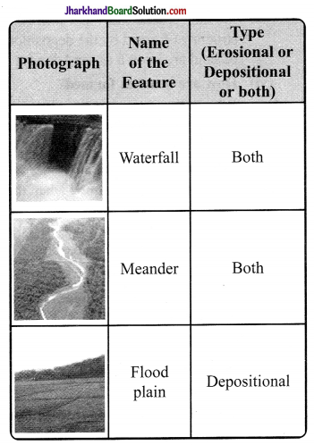
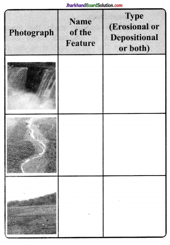
Observe the photographs given below. These are various features made by a river. Identify them and also tell whether they are erosional or depositional or landforms formed by both.

JAC Class 7 Social Science Solutions Geography Chapter 3 Our Changing Earth 1

Answer:
JAC Class 7 Social Science Solutions Geography Chapter 3 Our Changing Earth 2

(For Fun)

Question 6.
Solve the crossword puzzle with the help of given clues.
JAC Class 7 Social Science Solutions Geography Chapter 3 Our Changing Earth 3a
Across:
2. Loop like bend of river 4. Solid form of water
7. Moving mass of ice
9. Sudden descent of water in bed of river
11. Natural cavity on weak rocks formed by action of waves
12.Embankment on river that keeps river in its channel
13. Large body of sea water
14. Dry area where sand dunes are found
15. Small hill of sand piled by action of wind
16. Flat plain formed by river depoits during time of flood

Down:
1. Rise and fall of water caused by friction of wind on water surface
3. Flow of water in channel
5. Steep perpendicular face of rock along sea coast
6. Debris of boulder and coarse material carried by glacier
8. Crescent shaped lake formed by river meander
10. Fine sand deposited by action of wind
13. Isolated mass of rising steep rock near coastline
14. Alluvial tracts of land at mouth of river formed by river deposits

AcrossDown
2. Meander1. Wave
4. Ice3. River
7. Glacier5. Cliff
9.Waterfall6. Moraine
11. Caves8. Ox Bow lakes
12. Levee10. Loess
13. Sea13. Stack
14. Desert14. Delta
15. Sand dune
16. Flood Plain


JAC Class 7th Geography Our Changing Earth Important Questions and Answers

Multiple Choice Questions

Question 1.
The earthquake is measured with the help of
(a) Compass
(b) Seismograph
(c) Thermometer
(d) Lactometer
Answer:
(b) Seismograph

Question 2.
Sand dunes are
(a) hill like structure
(b) cave like structure
(c) wall like structure
(d) none of these
Answer:
(a) hill like structure

JAC Class 7 Social Science Solutions Geography Chapter 3 Our Changing Earth

Question 3. Inside the earth, the molten magma moves in a……manner.
(a) circular
(b) vertical
(c) horizontal
(d) spiral
Answer:
(b) vertical

Question 4.
The highest waterfall in the world is
(a) Jog Falls
(b) Victoria Falls
(c) Niagra Falls
(d) Horseshoe Falls
Answer:
(c) Niagra Falls

Question 5.
Loess is found in
(a) mountains
(b) sea
(c) plains
(d) deserts
Answer:
(d) deserts

Question 6.
Colour of infrared images that represent sandy areas, sand dunes and beaches is
(a) yellow
(b) white – cream
(c) red magenta
(d) pink – white
Answer:
(b) white – cream

Question 7.
Broken plates are known as
(a) Farallon plate
(b) Scotia plate
(c) Tectonic plate
(d) Lithospheric plate
Answer:
(d) Lithospheric plate

Question 8.
The forces which act in the interior of the earth is known as
(a) Endogenic Force
(b) Magnetic Force
(c) Exogenic Force
(d) Gravitational Force
Answer:
(a) Endogenic Force

Question 9.
One of the Endogenic Force is theSudden Force. These include/s
(a) Volcano
(b) Landslides
(c) Earthquake
(d) All of these
Answer:
(d) All of these

Question 10: The activity in a river which erodes the landscape is
(a) Swimming of humans
(b) Growth of weeds
(c) Running water
(d) Boating
Answer:
(c) Running water

Very Short Answer Type Questions

Question 1.
During an earthquake we should keep away from which places?
Answer:
During an earthquake we should keep away from the places such as chimneys, windows that shatter including mirrors and picture frames and fire places.

Question 2.
Name the major agents of erosion.
Answer:
The major agents of erosion are wind, water and ice.

Question 3.
What do you meant by vent?
Answer:
Vent is the narrow opening of the volcano.

JAC Class 7 Social Science Solutions Geography Chapter 3 Our Changing Earth

Question 4.
Name the scale that is used to measurethe earthquake.
Answer:
The Richter Scale is used to measure themagnitude of the earthquake.

Question 5.
What do you mean by distributaries?
Answer:
When the river begins to break up to a number of streams are known as distributaries.

Question 6.
Which are the two methods that wear away the landscape?
Answer:
The two methods that wear away the landscape are weathering and erosion.

Question 7.
What are the activities on the surface of the earth that create different landforms?
Answer:
The activities on the surface of the earth that create different landforms are the process of erosion and deposition.

Question 8.
What do you mean by focus?
Answer:
The focus is the place in the crust where the movement starts.

Question 9.
When the river tumbles at the steep angle over very hard rocks or down a steep valley side then what is formed?
Answer:
When the river tumbles at the steep angle over very hard rocks or down a steep valley side then waterfall is formed.

Question 10.
What is formed when the river enters the plain and twists and turns forming large bends?
Answer:
Meander is formed when the river enters the plain and twists and turns forming large bends.

Short Answer Type Questions

Question 1.
In which manner glacial morains form?
Answer:
The materials which are carried by the glacier such as rocks small and big; sand and silt gets deposited. These depositions form glacial moraines.

Question 2.
What do you understand by the term delta?
Answer:
A feature is formed when river drops off the sediments in low-lying areas usually as they enter the sea, ocean or estuary is known as delta. It has triangular shape sometimes.

JAC Class 7 Social Science Solutions Geography Chapter 3 Our Changing Earth

Question 3.
What are the three types of earthquake waves?
Answer:
The three types of earthquake waves are

  • Longitudinal waves or P waves
  • Transverse waves or S waves
  • Surface waves or L waves

Question 4.
Where are Victoria Falls and Niagra Falls located?
Answer:
Victoria Falls is located on the borders of Zambia and Zimbabwe in Africa. Niagra Falls is situated on the borders of United States of America and Canada.

Question 5.
List the important lithospheric plates.
Answer:
The important lithospheric plates are

  • The Indo-Australian Plate
  • The Eurasian Plate
  • The North American Plate
  • The South American Plate
  • The African Plate
  • The Pacific Plate
  • The Antarctic Plate

Question 6.
What are the agents of denudation?
Answer:
Denudation is the effect of two main processes – Endogenous and Exogenous.

  • The agents of denudation are
  • Wind
  • Running water
  • Sea waves
  • Glaciers

Question 7.
How do we measure the intensity of an earthquake?
Answer:
Seismograph is a machine which helps to measure an earthquake and the magnitude is measured on the Richter Scale. Hence, the intensity of the earthquake is measured in the following way:

MagnitudeAffect
4.0 or lessonly little can be felt
Over 5.0cause damages such as things falling
6.0 or morefeel very strong
7.0 or highermajor damage of this earthquake

Question 8.
When does ox-bow lakes form?
Answer:
When there is a continuous erosion and deposition occurs along the sides of the meander, the ends of the meander loop come very closer. Hence, in due period of time the meander loop cuts off from the river and forms a cut-off lake which is known as ox-bow lakes.

Question 9.
What are the two types of tectonic movement?
Answer:
The two types of tectonic movements are Vertical earth movement and Horizontal earth movement.

JAC Class 7 Social Science Solutions Geography Chapter 3 Our Changing Earth

Question 10.
Where do you think volcanoes are found?
Answer:
The place where the tectonic plates are pulled apart or come together, the volcanoes are found there. These are also found where there is thinning and stretching of earth’s crust happens such as in the rift valley (Africa).

Long Answer Type Questions

  • Due to continuous erosion and deposition along the sides of the meander, the ends of the meander loop come very close. In due period of time the meander loop cuts off from the river and forms a cut-off lake which is also called as an oxbow lake.
  • At times the river overflows its banks and and this leads to the flooding of the neighbouring areas. As it floods heavily, it deposits

Question 1.
Discuss the work of a river.
Answer:
Work of a river:

1. In the river, the running water erodes the landscape. When the river tumbles at steep angle over very hard rocks or down a steep valley side it forms a waterfall.layers of fine soil and other materials which is known as sediments along its banks. This leads to the formation of a flat fertile flood plain. This raised banks are known as levees.

2. As the river proceeds towards the sea, the speed of the flowing water
decreases and the river begins to break up into a number of streams which are known as distributaries. The river becomes so slow that it begins to deposit its load. And, each distributary forms its own mouth. The collection of sediments from all the mouths hence forms a delta.

JAC Class 7 Social Science Solutions Geography Chapter 3 Our Changing Earth

Question 2.
Write short note on the work of sea waves.
Answer:
Work of sea waves:

  • The sea waves gives rise to coastal landforms with the help of erosion and deposition. Sea waves . continuously strike at the rocks and the cracks develop. Over the period, they become larger and wider. Hence, hollow like caves are formed on the rocks. They are known as sea caves.
  • As these cavities become bigger and bigger only the roof of the caves remain at last and thus forms the sea arches.
  • Furthermore, erosion breaks the roof and only the walls are left. These walls like features are known as stacks.
  • Above sea water, the steep rocky coast rises almost vertically is known as sea cliff”.
  • The sea waves which deposits sediments along the shores forms beaches.

JAC Class 7 Social Science Solutions

JAC Class 7 Social Science Solutions Geography Chapter 6 Natural Vegetation and Wild Life

JAC Board Class 7th Social Science Solutions Geography Chapter 6 Natural Vegetation and Wild Life

JAC Class 7th Geography Natural Vegetation and Wild Life InText Questions and Answers

Page 39

Question 1.
Salima was excited about the summer camp she was attending. She had gone to visit Manali in Himachal Pradesh along with her class mates. She recalled how surprised she was to see the changes in the landform and natural vegetation as the bus climbed higher and higher. The deep jungles of the foothills comprising sal and teak slowly disappeared.

She could see tall trees with thin pointed leaves and cone shaped canopies on the mountain slopes. She learnt that those were coniferous trees. She noticed blooms of bright flowers on tall trees. These were the rhododendrons. From Manali as she was travelling up to Rohtang pass she saw that the land was covered with short grass and snow in some places.

JAC Class 7 Social Science Solutions Geography Chapter 6 Natural Vegetation and Wild Life

Question 1.
Now can you tell why Salima saw changes in the natural vegetation as she climbed higher and higher? What type of vegetations did she see in the Himalayas starting with the foothills and going to the higher altitudes?
Answer:
Salima saw changes in the natural vegetation as she climbed higher and higher because of change in climate, slope, thickness of soil. The type of vegetation she saw in the Himalayas starting with the foothills and going to the. higher altitudes are trees such as cedar, pine, chir; snow covered coniferous forests and short grass.

Question 2.
Like Salima, when you go to visit any new place, notice the type of natural vegetation occurring there and try to think of factors responsible for the growth of such vegetation in that habitat.
Answer:
Students need to do it themselves.

Question 3.
Note down if any human interference has taken place in that area in terms of deforestation, grazing, cultivation of cash crops, constructional activities etc.
Answer:
Students need to do it themselves.

Page 41

Question 4.
Where in India do tropical evergreen and tropical deciduous forests occur? Name the states.
Answer:
In India, the tropical evergreen and tropical deciduous forests occur are

  • Tropical evergreen forests: Assam, West Bengal, Nagaland, Meghalaya, Tripura, Karnataka, Tamil Nadu.
  • Tropical deciduous forests: Odisha, Jharkhand Chhattisgarh, Kerala.

Question 5.
Which type of forest dominates most part of India?
Answer:
The tropical deciduous forests dominates part of India.

Page 43

Question 6.
Look around in your surroundings and find out the articles made of hard wood and soft wood.
Answer:
The articles made of Hard wood Doors, windows, tables, chairs, beds, cupboards, etc. Soft wood Match boxes, packaging materials, boats, etc.

Question 7.
Find out and learn few names of trees of your locality.
Answer:
We see mango, neem, guava, peepal, jamun trees in our locality.

JAC Class 7th Geography Natural Vegetation and Wild Life Textbook Questions and Answers

Question 1.
Answer the following questions.
(i) Which are the two factors on which the growth of vegetation mostly depends?
Answer:
The temperature and moisture are the two factors on which the growth of vegetation mostly depends.

(ii) Which are the three broad categories of natural vegetation?
Answer:
Forests, grasslands and shrubs are the three broad categories of natural vegetation.

JAC Class 7 Social Science Solutions Geography Chapter 6 Natural Vegetation and Wild Life

(iii) Name the two hardwood trees commonly found in tropical evergreen forest.
Answer:
Mahogany and rosewood are the two hardwood trees commonly found in tropical evergreen forest.

(iv) In which part of the world and tropical deciduous forest is found?
Answer:
The tropical deciduous forest are found in northern Australia, Central America and in large part of India.

(v) In which climatic conditions, citrus fruits cultivated?
Answer:
In hot dry summers and mild rainy winters, citrus fruits are cultivated.

(vi) Mention the uses of coniferous . forest.
Answer:
The coniferous forests are used for manufacturing paper and newsprint, match boxes, packing boxes.

(vii) In which part of the world is seasonal grassland is found?
Answer:
In the mid-latitudinal zones and in the interior parts of the continents of the world, the seasonal grasslands are found.

Tick (√) the correct answer.

Question 2.
(i) Mosses and Lichens are found in
(a) Desert vegetation
(b) Tropical evergreen forest
(c) Tundra vegetation
Answer:
(c) Tundra vegetation

(ii) Thorny bushes are found in
(a) Hot and humid tropical climate
(b) Hot and dry desertic climate
(c) Cold polar climate
Answer:
(b) Hot and dry desertic climate

(iii) In tropical evergreen forest, one of the common animals is
(a) Monkey
(b) Giraffe
(c) Camel
Answer:
(a) Monkey

(iv) One important variety of coniferous forest is:
(a) Rosewood
(b) Pine
(c) Teak
Answer:
(b) Pine

(v) Steppe grassland is found in
(a) S. Africa
(b) Australia
(c) Central Asia
Answer:
(c) Central Asia

Question 3.
Match the following.

(i) Walrus(a) Soft wood tree
(ii) Cedar(b) An animal of tropical deciduous forest
(iii) Olives(c) A polar animal
(iv) Elephants(d) Temperate grassland in Australia
(v) Campos(e) Thorny shrubs
(vi) Downs(f) A citrus fruit

Answer:

(i) Walrus(c) A polar animal
(ii) Cedar(a) Soft wood tree
(iii) Olives(f) A citrus fruit
(iv) Elephants(b) An animal of tropical deciduous forest
(v) Campos(g) Tropical grassland of Brazil
(Vi) Downs(d) Temperate grassland in Australia

Question 4.
Give reasons.

  1. The animals in polar region have thick fur and thick skin.
  2. Tropical deciduous trees shed their leaves in the dry season.
  3. The type and thickness of vegetation changes from place to place.

Answer:

  1. The animals in polar region have thick fur and thick skin to protect themselves from extreme cold climatic conditions.
  2. Transpiration occurs through leaves. To reduce transpiration in dry season, the tropical deciduous trees shed their leaves in dry season.
  3. Due to variation in temperature and moisture, the type and thickness of vegetation changes from place to place.

(For Fun)

Question 5.
In the given crossword table given below, some words are hidden. They are all about vegetation and wildlife and are to be found horizontally and vertically. Two have been worked out for you. Work in pairs with a friend
JAC Class 7 Social Science Solutions Geography Chapter 6 Natural Vegetation and Wild Life 1

VegetationWildlife
1. Neem1. Bear
2. Bamboo2. Whale
3. Flora3. Ox
4. Lichen4. Zebra
5. Pine5. Goat
6. Chir6. Tiger
7. Grass7. Yak
8. Taiga8. Owl
9. Tulsi9. Deer
10. Fir10. Lion
11. Tundra11. Fowl
12. Ebony12. Horse
13. Pampas13. Pig
14. Llanos14. Camel
15. OakWildlife
16. Mosses


JAC Class 7th Geography Natural Vegetation and Wild Life Important Questions and Answers

Multiple Choice Questions

Question 1.
Coniferous forests are also known as
(a) Mediterranean
(b) Taiga
(c) Tundra
(d) None of these
Answer:
(b) Taiga

JAC Class 7 Social Science Solutions Geography Chapter 6 Natural Vegetation and Wild Life

Question 2.
The forest which comprises both hard wood and softwood trees is
(a) Coniferous forest
(b) Tropical evergreen forest
(c) Temperate evergreen forest
(d) Tropical deciduous forest
Answer:
(c) Temperate evergreen forest

Question 3.
Tropical deserts are found on the margins of the continents.
(a) Northern
(b) Western
(c) Southern
(d) Eastern
Answer:
(b) Western

Question 4.
Tropical grasslands in East Africa is
(a) Campos
(b) Llanos
(c) Savannah
(d) Prairie
Answer:
(c) Savannah

Question 5.
kind of vegetation is found in steppes.
(a) Temperate grasslands
(b) Tropical evergreen forests
(c) Tropical grasslands
(d) Temperate deciduous forests
Answer:
(a) Temperate grasslands

Question 6.
The given below is a coniferous tree
(a) Teak
(b) Cedar
(c) Rosewood
(d) Pine
Answer:
(d) Pine

Question 7.
Given below tree is not a hardwood tree
(a) Rosewood
(b) Eucalyptus
(c) Ebony
(d) Mahogany
Answer:
(b) Eucalyptus

Question 8.
The most commonly found primate in India is
(a) The Rhesus Macaque
(b) The Red-faced baboon
(c) The Proboscis monkey
(d) The Grey langur
Answer:
(a) The Rhesus Macaque

JAC Class 7 Social Science Solutions Geography Chapter 6 Natural Vegetation and Wild Life

Question 9.
The only species of bears found in India are
(a) Sloth bear
(b) Himalayan Black bear
(c) Asian Sun Bear
(d) None of these
Answer:
(b) Himalayan Black bear

Question 10.
Thorny bushes are mainly found in
(a) Cold polar climate
(b) Hot and humid tropical climate
(c) Hot and dry desert climate
(d) None of these
Answer:
(c) Hot and dry desert climate

Very Short Answer Type Questions

Question 1.
What do the term Taiga mean in Russian language?
Answer:
The term taiga means untouched or pure in the Russian language.

Question 2.
What is the reason which makes the coniferous forest unique?
Answer:
The reason which makes the coniferous forest unique is the tall and softwood evergreen trees. .

Question 3.
What is the alternate name of tropical evergreen forests?
Answer:
The alternate nathe of tropical evergreen forests is tropical rainforests.

Question 4.
Where is Veld Temperate Grassland situated?
Answer:
Veld Temperate Grassland is situated in Africa.

Question 5.
What is the main feature of polar region?
Answer:
The main feature of polar region is that it is very cold.

Question 6.
Where are Campos found?
Answer:
Campos are found in Brazil.

Question 7.
What animals are found in the tropical grasslands?
Answer:
Animals which are found in the tropical grasslands are elephants, zebras, giraffes, deer, leopards, etc.

Question 8.
Where are Savannah grasslands found?
Answer:
Savannah grasslands are found in Africa.

Question 9.
Which place is known as ‘Orchards of the World’ and why?
Answer:
Mediterranean places are known as ‘Orchards of the World’ because for their fruit cultivation.

JAC Class 7 Social Science Solutions Geography Chapter 6 Natural Vegetation and Wild Life

Question 10.
In which region temperate evergreen forests are found?
Answer:
The thick forests are found in the regions near the equator and close to the tropics.

Short Answer Type Questions

Question 1.
The equatorial forests are considered as the lungs of the earth. Why?
Answer:
The tropical evergreen forest or the equatorial forests in Brazil are so enormous that it is like the lungs of the earth.

Question 2.
What are the features of Mediterranean trees?
Answer:
The features of Mediterranean trees are that they adapt themselves to dry summers with the help of their thick barks and wax coated leaves which help them to lessen the transpiration.

Question 3.
Write a note on anaconda.
Answer:
Anaconda is one of the world’s largest snakes. They are very huge and non- poisonous snakes. They are found in the tropical rainforest. Anaconda can kill and eat a large animal such as a crocodile.

Question 4.
Does altitude affect vegetation? If yes then-how?
Answer:
Yes, altitude affects vegetation. A close relationship between height of land and the character of vegetation is present. With the change in height, the climate changes and thus changes the natural vegetation.

Question 5.
Name the different types of grasslands. Answer: Different grasslands are:

  • Savannah in East Africa
  • Campos in Brazil
  • Llanos in Venezuela
  • Pampas in Argentina
  • Prairie in North America
  • Veld in South Africa
  • Steppe in Central Asia
  • Down in Australia.

Question 6.
Write the important features of tropical evergreen forests.
Answer:
Important features of tropical evergreen forests are:

  • These forests are so dense and opaque that thick canopies and sunshades are developed which do not allow the sunlight to penetrate and go inside the forest.
  • There is no particular dry season, hence the trees do not shed their leaves altogether. This keeps the forest evergreen.
  • Hardwood trees such as rosewood, ebony and mahogany, etc., are found here.

Question 7.
Brief about the tropical grasslands.
Answer:
The tropical grasslands develop on either side of the equator and extend till the tropics. This vegetation grows in the regions of moderate to low amount of rainfall. The grass can grow very tall to a height of about 3 to 4 metres. One of this type of grasslands are Savannah grasslands of Africa. Some ; of the animals found here are elephants, zebras, giraffes, deer and leopards.

JAC Class 7 Social Science Solutions Geography Chapter 6 Natural Vegetation and Wild Life

Question 8.
What are the different kinds of h natural forests found?
Answer:
The different kinds of natural forests’ found are

  • Tropical evergreen forest
  • Tropical deciduous forest
  • Temperate evergreen forest
  • Temperate deciduous forest
  • Mediterranean vegetation
  • Coniferous forest

Question 9:
Write a short note on the natural vegetation and wildlife found in the polar regions.
Answer:
The growth of natural vegetation is very limited here as the polar regions are extremely cold. Only mosses, lichens and very and small shrubs are found here and grow during the very short summer. This is known as Tundra type of vegetation and found in the polar regions of Europe, Asia and North America. The animals found here have thick fur and skin which protect them from the cold and harsh climatic

Long Answer Type Questions

Question 10.
Explain different types of forests.
Answer:
Different types of forests are:

  • Tropical evergreen forests
  • Tropical deciduous forests
  • Temperate evergreen forests
  • Temperate deciduous forests
  • Mediterranean vegetation
  • Coniferous forests

Tropical evergreen forests :
These forests are very dense and thick and found in the regions near the equator and close to the tropics. They receive heavy rain all through the year. The trees of these forests do not shed their leaves altogether and therefore they remain green all the time and called as evergreen. Hardwood trees like rosewood, ebony and mahogany are found here.

Tropical deciduous forests:
These forest are found in the areas which experience seasonal changes and trees shed their leaves in the dry season to conserve water. The hardwood trees such as sal, teak, neem and shisham are found in this region. Animals like tigers, lions, elephants, langoors and monkeys are found in these forests.

JAC Class 7 Social Science Solutions Geography Chapter 6 Natural Vegetation and Wild Life

Temperate evergreen forests:
These forests are found along the eastern margin of the continents. They contains both hard and softwood trees such as oak, pine, eucalyptus, etc.

Temperate deciduousf orests:
Trees of these forests shed their leaves in dry season. Trees found here are oak, ash, beech, etc. Deer, foxes, wolves, etc., are some of the animals found in these forests.

Mediterranean vegetation :
It is found in the areas around the Mediterranean sea in Europe, Africa and Asia. Citrus fruits like oranges, figs, olives and grapes are cultivated in the Mediterranean regions.

Coniferous forests :
These forests are also known as Taiga. They are tall, softwood evergreen trees. Chir, pine, cedar are important types of trees found in these forests. Silver, fox, mink, polar bear are the some of the animals found here.

JAC Class 7 Social Science Solutions

JAC Class 7 Social Science Solutions Geography Chapter 2 Inside Our Earth

JAC Board Class 7th Social Science Solutions Geography Chapter 2 Inside Our Earth

JAC Class 7th Geography  Inside Our Earth InText Questions and Answers

Page 9

Question 1.
Collect pictures of some monuments and find out which are the rocks used to build them.
Answer:
Students can collect pictures of monuments which are made of

  • White marbles: Victoria Memorial in Kolkata; Lake Palace in Udaipur; Taj Mahal in Agra.
  • Red Sandstones: Hawa Mahal in Jaipur; Buland Darwaza in Fatehpur Sikri near Agra Red Fort in Delhi.

Page 10

Question 2.
What are the minerals found in your state? Collect some samples to show in your class.
Answer:
Students need to do it on their own.

JAC Class 7 Social Science Solutions Geography Chapter 2 Inside Our Earth

JAC Class 7th Geography  Inside Our Earth Questions and Answers

Answer the following questions.

Question 1.

  1. What are the three layers of the earth?
  2. What is a rock?
  3. Name three types of rocks.
  4. How are extrusive and intrusive rocks formed?
  5. What do you mean by a rock cycle?
  6. What are the uses of rocks?
  7. What are metamorphic rocks?

Answer:
1. The three layers of our earth are Mantle

2. A rock is made up of a natural mass of mineral matter that makes up the earth’s cmst. They can be of different shape, colour, size and texture.

3. Three types of rocks are:

  • Igneous rocks and primary rocks
  • Sedimentary rocks
  • Metamorphic rocks

4. When the molten lava comes down, it cools down very fast and becomes solid. In this way, the rocks formed on the crust are called the extrusive rocks. For example – basalt. Sometimes the molten magma cools down deep inside the crust of the earth. So, the solid rocks are thus formed and called the intrusive rocks. For example – granite.

5. One certain type of rock changes to another type under certain conditions in a cyclic way. This process of transformation of the rock from one to another is called the rock cycle such as igneous rocks change into sedimentary rocks. When the igneous and sedimentary rocks exposed to extreme heat. and pressure, they change into metamorphic rocks. The metamorphic rocks which are still under heat and pressure meet down to form molten magma. This again cool down and solidify into igneous rocks.

6. The rocks are used for making houses, buildings, roads. Stones are used in many games such as hopscotch (stapu / kitkit), five stones (gitti), seven stones (pitthoo) etc.

7. The igneous and the sedimentary rocks are exposed to heat and pressure, they changes into metamorphic rocks. Such as clay changes into slate, limestone changes into marble.

Tick (√) the correct answer.

Question 2:
(i) The rock which is made up of molten magma is
(a) Igneous
(b) Sedimentary
(c) Metamorphic
Answer:
(a) Igneous

(ii) The innermost layer of the earth is
(a) Crust
(b) Core
(c) Mantle
Answer:
(b) Core

JAC Class 7 Social Science Solutions Geography Chapter 2 Inside Our Earth

(iii) Gold, petroleum and coal are examples of
(a) Rocks
(b) Minerals
(c) Fossils
Answer:
(b) Minerals

(iv) Rocks which contain fossils are
(a) Sedimentary rocks
(b) Metamorphic rocks
(c) Igneous rocks
Answer:
(c) Igneous rocks

(v) The thinnest layer of the earth is
(a) Crust
(b) Mantle
(c) Core
Answer:
(c) Core

Question 3.
Match the following.

(i) Core(a) Changes into slate
(ii) Minerals(b) Used for roads and buildings
(iii) Rocks(c) Made of silicon and alumina
(iv) Clay(d) Has definite chemical composition
(v) Sial(e) Innermost layer
(f) Changes into slate
(g) Process of transformation of the rock

Answer:

(i) Core(e) Innermost layer
(ii) Minerals(d) Has definite chemical composition
(iii) Rocks(b) Used for roads and buildings
(iv) Clay(f) Changes into slate
(v) Sial(c) Made of silicon and alumina

Question 4.
Give reasons.

  1. We cannot go to the centre of the earth.
  2. Sedimentary rocks are formed from sediments.
  3. Limestone is changed into marble.

Answer:
1. We cannot go to the centre of the earth because we need to dig around 6000 km under the ocean bed which is not possible. Also, the centre of the earth has very high temperature and pressure.

2. Rocks break down into small pieces called the sediments. These sediments are transported and deposited by water, wind, etc. These loose sediments are composed and hardened to form layers of rocks called the sedimentary rocks.

3. Limestone is changed to marble because sedimentary rocks changes into metamorphic rocks under a extensive pressure and heat. (For Fun)

JAC Class 7 Social Science Solutions Geography Chapter 2 Inside Our Earth

Question 5.

  1. What are the minerals most commonly used in the following objects?
  2. Identify some more objects made up of different minerals.

JAC Class 7 Social Science Solutions Geography Chapter 2 Inside Our Earth 1
Answer:

  1. Karhai, Pan, Taw CL Hammer – Iron, steel Bell, lamp – brass, iron Ornaments – gold, pearl
  2. Utensils – aluminium, steel, copper, brass Wires – copper, aluminium Almirah – Iron Doors – Iron Windows – Iron, glass, aluminium

JAC Class 7th Geography  Inside Our Earth Important Questions and Answers

Multiple Choice Questions

Question 1.
The continental mass of the crust is about km and km on the ocean floor.
(a) 5,65
(b) 45,10
(c) 35, 5
(d) 10, 50
Answer:
(c) 35, 5

Question 2.
……… is the deepest mine in the world.
(a) South Africa
(b) Australia
(c) South America
(d)Asia
Answer:
(a) South Africa

Question 3.
Rock sediments are transported and deposited by
(a) wind
(b) water
(c) Both ‘a’ and ‘b’
(d) None of these
Answer:
(c) Both ‘a’ and ‘b’

Question 4.
We use the following as fuel /s:
(a) petroleum
(b) coal
(c) natural gas
(d) all of these
Answer:
(d) all of these

JAC Class 7 Social Science Solutions Geography Chapter 2 Inside Our Earth

Question 5.
The Deccan plateau is made up of
(a) clay and sandstone
(b) granite and basalt
(c) limestone
(d) basalt
Answer:
(d) basalt

Question 6.
From the sand grains is made.
(a) silicon
(b) sandstone
(c) limestone
(d) granite
Answer:
(b) sandstone

Question 7.
Below the crust, the mantle extends upto a depth of
(a) 2900 km
(b) 2000 km
(c) 2100 km
(d) 3900 km
Answer:
(a) 2900 km

Question 8.
The thickness of the outer layer of the earth is
(a) 40 km
(b) 60 km
(c) 70 km
(d) 100 km
Answer:
(b) 60 km

Question 9.
The main mineral constituents of the continental mass are
(a) silica and magnesium
(b) nickel and iron
(c) silica and alumina
(d) nickel and magnesium
Answer:
(c) silica and alumina

Question 10. The oceanic crust mainly consists of silica and magnesium called as
(a) sial
(b) sima
(c) nife
(d) nima
Answer:
(b) sima

Very Short Answer Type Questions

Question 1.
What is the radius of the core of the earth?
Answer:
The radius of the core of the earth is 3500 km.

Question 2.
What is the crust of the earth made up of?
Answer:
The crust of the earth is made up of different types of rocks.

JAC Class 7 Social Science Solutions Geography Chapter 2 Inside Our Earth

Question 3.
In which rock igneous and sedimentary rocks change?
Answer:
In metamorphic rocks the igneous and sedimentary rocks changes.

Question 4.
What are the main components of the core?
Answer:
The main components of the core are nickel and iron. It is generally called as nife.

Question 5.
What is the special trait of the uppermost layer of the earth?
Answer:
The special trait of the uppermost layer of the earth is that it is the thinnest of all the layers.

Question 6.
What are the components of the oceanic crust?
Answer:
The components of the oceanic crust are silica and magnesium.

Question 7.
What do you mean by lava?
Answer:
A raging and fiery red molten magma coming out from the interior of the earth on its surface is called as lava.

Question 8.
What do you mean by volcano?
Answer:
Volcano happens when magma from deep below forces its way upto earth’s outer surface.

Question 9.
What are minerals?
Answer:
Naturally occurring substances which have specific physical and definite chemical properties and composition are called the minerals.

Question 10.
What do you understand by crust?
Answer:
Crust is the uppermost layer of the earth’s surface.

Short Answer Type Questions

Question 1.
Why the igneous rocks are called the primary rocks or the basic rocks?
Answer:
Our earth consists of a hot molten material which have high temperatures and pressure deep below. Igneous rocks are formed on cooling and solidification of the matter and they make up about two-thirds of the earth’s crust. Hence, they are called primary or basic rocks.

JAC Class 7 Social Science Solutions Geography Chapter 2 Inside Our Earth

Question 2.
Volcanic ashes are found after the volcano’s eruption. What are these volcanic ashes?
Answer:
The material that comes out of the volcano are generally of three types; they are solid, liquid and gases. The solid materials are large and small fragments and pieces of rocks which are known as cinder and fine particles of these are called volcanic ashes.

Question 3.
Why formation of rocks is a slow process?
Answer:
Formation of rocks is a slow process because:

  • Climate and weather breaks the parent rocks into numerous smaller pieces.
  • Plants and animals organism helps in weathering of rocks.
  • Elevation or topography also helps in weathering of rocks.
  • Time and period also plays major role in the slow process.

Question 4.
Give examples of each of the following:
(a) Igneous rocks
(b) Sedimentary rocks
(c) Metamorphic rocks
Answer:
Examples of each of the following:
(a) Igneous rocks – basalt
(b) Sedimentary rocks – limestone, coal, sandstone, shale
(c) Metamorphic rocks – marble, slate, gnesis

Question 5.
What do you mean by fossils?
Answer:
Fossils are the remains of the dead plants and animals trapped and confined in the layer of rocks. They generally formed from the hard parts bones or shells of living things.

Question 6.
How minerals are useful for mankind?
Answer:
Some of the minerals such as coal, natural gas and petroleum are used as fuels and also in industries. Iron, aluminium, gold, uranium, etc., are used in medicine, in fertilizers, etc. Hence, minerals are very useful for mankind.

Question 7.
What do you mean by mantle?
Answer:
The intermediate layer which lies between the crust and the core of the earth is called the mantle. Its average thickness is about 2900 km and is believed to comprises of solid ultra basic rocks which are rich in iron and magnesium.

Question 8.
Why the outer crust is important to us?
Answer:
The outer crust is important to us because the solidified outer crust of the earth is having a thin crust forms the base on which human life and civilization have developed. It also consists of the valuable soil and gives us most of our minerals.

JAC Class 7 Social Science Solutions Geography Chapter 2 Inside Our Earth

Question 9.
Differentiate between mantle and core.
Answer:

MantleCore
• Just underneath the crust means it is the middle or centric layer of the earth.• The innermost layer of the earth.
• It has a density of 3.5 km.• It has a density of 5.1 km.
• The main components of minerals are silica and magnesium i.e.; SIMA.• The main  components of minerals are nickel and ferrous (iron) i.e; NIFE.

Question 10.
Differentiate between minerals and rocks.

MineralsRocks
• Minerals have atomic structure and contains ore.• Rock is a collection and cluster of minerals.
• They have a specific and definite chemical composition.• -They does not have a definite chemical composition.
• There are about 2000 types of minerals.• Mainly they are of three types – igneous, sedimentary and metamorphic rocks.
• It is the natural inorganic compound which forms in the rocks.• It is a solid natural material formed in the earth’s crust.
MineralsRocks


Long Answer Type Questions

Question 1.
Write and describe the different types and features of the rocks.
Answer:
The different types of rocks are:

  • Igneous rocks
  • Sedimentary rocks
  • Metamorphic rocks

Igneous Rocks :
When the molten magma cools down it solidifies and rocks formed in this way are called igneous rocks. They are also known as primary rocks. These are mainly of two types:

Extrusive rocks :
When the molten lava comes on the surface of the earth, „ it cools down very fast and solidifies. Thus, rocks formed in this way on the crust are called extrusive rocks such as basalt.

Intrusive rocks:
When the molten magma cools down deep inside the earth’s crust and solidifies. Thus, rocked formed in this way are called intrusive rocks such as granite. They cool down slowly and form large grains.

Sedimentary rocks:
Small and tiny pieces of rocks are called sediments. These sediments are carried from and deposited by wind, water, etc. These ‘ loose sediments are compressed and hardened to form sedimentary rocks such as sandstone.

JAC Class 7 Social Science Solutions Geography Chapter 2 Inside Our Earth

Metamorphic rocks:
When igneous and sedimentary rocks are exposed to enormous heat and pressure they gradually change into metamorphic rocks such as clay changes into slate.

Important Features of Rocks:

  • They are found in different shapes, sizes, textures and colours.
  • On the earth’s crust, different types of rocks are found.
  • They can be as soft as clay or chalk and hard as granite.

Question 2:
Differentiate between crust and core.
Answer:

CrustCore
• Crust is the uppermost layer of the earth’s surface.• Core is the innermost layer of the earth’s surface.
• The main mineral components are silica and alumina i.e; SIAL.• The main mineral components are nickel and iron (ferrous) i.e; NIFE.
• The density is only 1.5 km.• The density is only 5.1 km.
• The temperature is between 50 degree to 55 degree Celcius.• It has pressure and the temperature is much higher than the crust.
• On continental mass the crust is about 35 km and on the ocean floors it is about 5 km.• It has a radius of 3500 km.


JAC Class 7 Social Science Solutions

JAC Class 7 Social Science Solutions Geography Chapter 5 Water

JAC Board Class 7th Social Science Solutions Geography Chapter 5 Water

JAC Class 7th Geography Water InText Questions and Answers

Question 1.
Why water is important for us?
Answer:
Water is the most useful and easily available thing on the earth for the survival. It is useful in many ways. We require water for drinking, cleaning, washing, cooking, bathing, putting out fire, etc.

Question 2.
Suggest some ways in which water can be conserved in your home and in your school.
Answer:
Some ways in which water can be conserved in our home and in our school are:

  • Use only the amount of water required.
  • We should not play with water.
  • We should repair the leakage taps.
  • We should try to minimise the wastage of water.
  • We should close the tap after use.
  • Rainwater harvesting tequniques should be applied.
  • We should not pollute water.
  • Water recycling should be done.

JAC Class 7th Geography Wate Textbook Questions and Answers

Question 1.
Answer the following questions.
(i) What is precipitation?
Answer:
Precipitation is the falling of moisture in the form of rainfall, snow, fog, sleet and hailstorm.

JAC Class 7 Social Science Solutions Geography Chapter 5 Water

(ii) What is water cycle?
Answer:
The process by which water continuously changes its form and circulates between oceans, seas, atmosphere and land is called as water cycle.

(iii) What are the factors affecting the height of the waves?
Answer:
The factors affecting the height of the waves are winds, earthquakes, under water disturbances, volcanic eruptions. The waves become bigger when the winds are stronger.

(iv) Which factors affect the movement of ocean water?
Answer:
The factors which affect the movement of ocean water are winds, temperature, gravitational pull of the sun, the earth and the moon. Apart from these, cold and warm currents also affect the movement of ocean current.

(v) What are tides and how are they caused?
Answer:
In a day, the rhythmic rise and fall of ocean or sea water which occurs twice are called as tides. They are caused by the strong gravitational pull exerted by the sun and moon on the surface of the earth.

(vi) What are ocean currents?
Answer:
The streams of water which flows constantly on the ocean’s surface in definite direction are called the ocean currents.

Question 2.
Give reasons.
(i) Ocean water is salty.
Answer:
Salt in the ocean comes from two sources: runoff from the land and openings in the seafloor. Rocks on land are the major source of salts dissolved in seawater. Rainwater that falls on land is slightly acidic, so it erodes rocks. Ocean water seeps into cracks in the seafloor and is heated by magma from the Earth’s core.

(ii) The quality of water is deteriorating.
Answer:
The quality of water is deteriorating because the portable water which is available is not always of good and pure in terms of quality. This is due to industrial effluents and outflow . and untreated water of factories and . industries get mixed into the rivers and streams. Sewer water also get mixed with them. Hence, it is unfit and poisonous for human and for other living being’s consumption.

Tick (√) the correct answer.

Question 3.

(i) The process by which water continually changes its form • and circulates between oceans, atmosphere and land
(a) Water cycle
(b) Tides
(c) Ocean currents
Answer:
(a) Water cycle

JAC Class 7 Social Science Solutions Geography Chapter 5 Water

(ii) Generally the warm ocean currents originate near
(a) Poles
(b) Equator
(c) None of these
Answer:
(b) Equator

(iii) The rhythmic rise and fall of ocean water twice in a day is called
(a) Tide
(b) Ocean current
(c) Wave
Answer:
(a) Tide

Question 4.
Match the following.

(i) Caspian Sea(a) Largest lake
(ii) Tide(b) Periodic rise and fall of water
(iii) Tsunami(c) Strong seismic waves Streams of water
(iv) Ocean currents(d) moving along definite paths
(e) Water cycle

Answer:

(i) Caspian Sea(a) Largest lake Periodic rise
(ii) Tide(b) and fall of water
(iii) Tsunami(c) Strong seismic waves
(iv) Ocean currents(d) Streams of water moving in along definite paths

Question 5.
(For Fun) Be a Detective
(i) The name of one river is hidden in each of the sentences below. Spot it. Example: Mandira, Vijayalakshmi and Surinder are my best friends
Answer:
Ravi
(a) The snake charmer’s bustee, stables where horses are housed, and the piles of wood, all caught fire accidentally. (Hint: Another name for River Brahmaputra)

(b) The conference manager put pad, material for reading and a pencil for each participant. (Hint: A distributary on the Ganga-Brahmaputra delta)

(c) Either jealousy or anger cause a person’s fall (Hint: Name of a juicy fruit!)

(d) Bhavani germinated the seeds in a pot (Hint: Look for her in West Africa)

(e) “I am a zonal champion now” declared the excited atheletic. (Hint: The river that has he biggest basin in the world)

(f) The tiffin box rolled down and all the food fell in dusty potholes. (Hint: Rises in India and journeys through Pakistan)

(g) Malini leaned against the pole when she felt that she was going to faint. (Hint: Her delta in Egypt is famous)

(h) Samantha mesmerised everybody with her magic tricks. (Hint: London is situated on her estuary)

(i) “In this neighbourhood, please don’t yell! Owners of these houses like to . have peace”. Warned my father when . we moved into our new flat”. (Hint: colour!)

(j) ‘Write the following words, Marc!’ “On”, “go”, “in” said the teacher to the little boy in KG Class. (Hint: Rhymes with ‘bongo’). Now make some more on your own and ask your classmates to spot the hidden name. You can do this with any name: that of a lake, mountains, trees, fruits, school items, etc.
Answer:
(a) Teesta
(b) Padma
(c) Orange
(d) Niger
(e) Amazon
(f) Indus
(g) Nile
(h) Thames
(i) Yellow
(j) Congo

Carry on Detective
(ii) With the help of an atlas, draw each river which you discoverd in For fun (i), on an outline map of the world. Answer: Student need to do it on their own.

JAC Class 7th Geography Water Important Questions and Answers

Multiple Choice Questions

Question 1.
The word Tsunami derived from a Japanese word which means
(a) Ocean waves
(b) Harbour waves
(c) Ocean wind
(d) None of these
Answer:
(b) Harbour waves

Question 2.
World Water Day is celebrated on
(a) 22nd March
(b) 22nd May
(c) 24th March
(d) 28th July
Answer:
(a) 22nd March

JAC Class 7 Social Science Solutions Geography Chapter 5 Water

Question 3.
The earth surface is …….covered by water.
(a) one-fourth
(b) one-third
(c) three-fourth
(d) half
Answer:
(c) three-fourth

Question 4.
The sources of fresh water are
(a) river, spring, salt lakes
(b) pond, river, glacier
(c) ocean, sea, river
(d) glacier, sea, river
Answer:
(b) pond, river, glacier

Question 5.
…….. has a saline water body.
(a) Glenwood Springs
(b) The Sambar lake
(c) The Amazon river
(d) None of these
Answer:
(b) The Sambar lake

Question 6.
The percentage of freshwater foundin rivers are
(a) 0.01%
(b) 0.00001%
(c) 0.001%
(d) 0.0001%
Answer:
(d) 0.0001%

Question 7.
A huge tidal wave is also called
(a) a Tsunami
(b) a tide
(c) a super wave
(d) all of these
Answer:
(a) a Tsunami

Question 8.
When the water covers much of the shore by rising to its highest level then the tide is called as
(a) Spring tide
(b) Neap tide
(c) Low tide
(d) igh tide
Answer:
(d) igh tide

Question 9.
The following is not a result of high tides
(a) generation of electricity
(b) growth of bananas
(c) better fishing
(d) better navigation
Answer:
(b) growth of bananas

Question 10.
The current which originates near the equator and moves towards the poles are
(a) warm ocean currents
(b) frozen ocean current
(c) cold ocean currents
(d) tidal ocean currents
Answer:
(a) warm ocean currents

Very Short Answer Type Questions

Question 1.
Which condition causes evaporation of water from earth’s surface?
Answer:
The condition which causes evaporation of water from earth’s surface is the sun’s heat.

Question 2.
Which place was the epicentre of the earthquake of 26th December, 2004?
Answer:
Sumatra was the epicentre of the earthquake of 26th December, 2004.

JAC Class 7 Social Science Solutions Geography Chapter 5 Water

Question 3.
What was the magnitude of 26th December, 2004 earthquake?
Answer:
The magnitude of 26th December, 2004 earthquake was 9.0 on the Richter scale.

Question 4.
What happens in the areas where warm and cold current meet?
Answer:
The areas where warm and cold current meet, there they experience a foggy and misty weather which makes navigation very difficult.

Question 5.
Which place/s are the best fishing grounds in the world?
Answer:
The best fishing grounds in the world are the seas around eastern coast of North America and Japan.

Question 6.
What are the major sources of fresh water?
Answer:
The major sources of fresh water are river, lakes, springs, glaciers and ponds.

Question 7.
Is it possible to float in the Dead Sea? Why?
Answer:
Yes, it is possible to float in the Dead Sea because it becomes very dense by the increased salt contents.

Question 8.
From where cold currents originates?
Answer:
Cold current originates from the poles.

Question 9.
What do you mean by waves?
Answer:
The water of the ocean surface rises and falls alternatively, they are known as waves.

Question 10
Which is the southernmost point ofIndia? What happened in 2004?
Answer:
Indira point is the southernmost point of India. It submerged due to Tsunami in 2004.

Short Answer Type Questions

Question 1.
What happens during high tide and low tide?
Answer:
When high tide occurs waves rise very high and water covers much of the sea shore. When low tide occurs water falls to its lowest level and go back and recedes from the shore.

Question 2.
Define salinity? What is the salinity of seas and oceans?
Answer:
Salinity is the amount of salt in grams present in 1000 grams of water. The average salinity of the oceans is 35 parts per thousand.

JAC Class 7 Social Science Solutions Geography Chapter 5 Water

Question 3.
Name the different types in which the movements of ocean w ater can be categorized.
Answer:
The movements of ocean water can be categorized as

  • waves
  • currents
  • tides

Question 4.
What is the initial sign or indication of a tsunami?
Answer:
The initial sign or indication of a tsunami is that there is a rapid withdrawal and pull-out of water from the coastal region followed by destructive and disastrous wave.

Question 5.
What do you mean by spring tide and neap tide?
Answer:
Spring tides occurs during the full moon and new moon days, when the sun, the earth and the moon are in the same line and the tides are at its highest level.Neap tide occurs when the moon is in its first and last quarter, then the ocean water get drawn in diagonally opposite directions by the gravitational pull of sun and earth which results in low tides.

Question 6.
In which way waterbodies are distributed on the surface of the earth?
Answer:
The following table gives the distribution of water in percentage

Saline waterOceans97.3
Fresh waterGround water0.68
Ice caps2.0
Fresh water lakes and Inland seas0.009
Salt lakes0.009
Atmosphere0.0019
Rivers0.0001
Total100.00

Question 7.
Differentiate between warm ocean current and cold ocean current.
Answer:
Difference between:

Warm ocean currentsCold ocean currents
• These originates near the equator and move towards the poles.• These carry water , from the polar or higher latitudes to tropical or lower latitudes.
• Such as – The Gulf Stream• Such as – The Labrador Ocean Current.
• It brings warm temperature over the surface of the land.• It bring the cold temperature over surface of the land.

Question 8.
Differentiate between waves and tides.

WavesTides
• Waves happens all day long means 24 hours a day.• Tides happens twice a day; once early morning and late at night.
• Due to the different actions of the wind, there are up and down movements of ocean water are called as waves.• Due to the gravitational pull of the sun and the moon, there are up and down movement of ocean water are called as tides.
• The waves are not so useful’. As a matter of fact, they can be destructive and devastating.• Tides are very useful.

Question 9.
What do you understand by vertical circulation of ocean water.
Answer:
When the water surface gets heated by sun, water evaporates and increases the concentration of salts. Surface water becomes more dense and sinks and eventually sub-surface water rises up. Hence, the salinity of ocean water causes vertical circulation.

JAC Class 7 Social Science Solutions Geography Chapter 5 Water

Question 10.
In which way Tsunami cause?
Answer:
A volcanic eruption, under water landslide, an earthquake shifts large amount of ocean water. Hence, huge and large waves are formed which are known as Tsunami.

Long Answer Type Questions

Question 1.
What are the important and major movements of ocean water?
Answer:
The important movements that occur in oceans can be classified as waves, tides and currents.

  • Waves occurs when the water on the surface of the ocean rises and falls alternatively. Waves are formed when winds scrape and push across the ocean surface. The bigger the wave becomes when the stronger the wind blows.
  • Tides are the rhythmic rise and fall of ocean water twice in a day. High tide occurs when water covers much of the shore by rising to its highest level. Low tide occurs, when water falls to its lowest level and recedes and move back from the shore. The strong gravitational pull exerted by the sun and the moon on the earth’s surface causes the tides.
  • Ocean Currents are the streams of water flowing constantly on the ocean surface in definite directions. The ocean currents may be warm or cold. Normally, the warm ocean currents originate near the equator and move towards the poles. The cold currents carry water from polar or higher latitudes to tropical or lower latitudes. The Labrador Ocean current is cold current while the Gulf Stream is a warm current.

Question 2.
Explain in brief about Tsunami.
Answer:
Tsunami:

  • Tsunami is a Japanese word which means ‘Harbour waves’ as the harbours get destroyed whenever there is tsunami.
  • A volcanic eruption, an earthquake or underwater landslides can shift large amounts of ocean water.
  • Hence, a huge tidal wave known as tsunami which may be as high as 15 m is formed. The largest tsunami ever measured was 150 m high. These waves travel at a speed of more than 700 km per hour.
  • The tsunami of 2004 caused devastating and disastrous damage in the coastal areas of India. The Indira point in the Andaman and Nicobar islands got submerged after the tsunami.
  • On 22nd December, 2018, huge, monstrous and gigantic waves crashed into the coastal areas of Java and Sumatra in Indonesia. The volcano named Anak Karakatau erupted again on the following day causing huge damage which took many lives.
  • These damage caused to life and property are due to the lack of monitoring the early warning systems and knowledge among the coast dwellers.

JAC Class 7 Social Science Solutions

JAC Class 7 Social Science Solutions Geography Chapter 9 Life in the Deserts

JAC Board Class 7th Social Science Solutions Geography Chapter 9 Life in the Deserts

JAC Class 7th Geography Life in the Deserts InText Questions and Answers

Page 69

Question 1.
Can you name some more passes in the Himalayas?
Answer:
Banihal Pass, Burzil Pass, Aghil Pass, etc., are the passes in Himalayas.

JAC Class 7th Geography Life in the Deserts Textbook Questions and Answers

Question 1.
Answer the following questions.
(a) What are the two types of deserts found in the world?
Answer:
The two types of deserts found in the world are the hot deserts and the cold deserts.

(b) In which continent is the Sahara desert located?
Answer:
In Africa, the Sahara desert is located.

JAC Class 7 Social Science Solutions Geography Chapter 9 Life in the Deserts

(c) What are the climatic conditions of the Ladakh desert?
Answer:
The climatic conditions of the Ladakh desert is exceptionally cold and very dry due to high altitude. In summer, the day temperature are just above zero degree and at night, the temperature are below -30 degree. Most of the time in winters they have the temperatures below -40 degree. The region experiences hot burning sunlight and freezing winds.

(d) What mainly attracts tourists to Ladakh?
Answer:
Treks to the meadows, glaciers and the gompas attract the tourists in Ladakh. In winter, the ceremonies and festivities in which the local people engaged themselves also attract the tourists.

(e) What type of clothes the people of the Sahara desert wear?
Answer:
The types of clothes people in the Sahara desert wear are the heavy robes.

(f) Name the trees that grow in Ladakh.
Answer:
The trees that grow in Ladakh are fruit trees such as apple, apricots and walnuts. Also grown there are scanty patches of shrubs and grasses, groves of willows and poplars.

Tick (√) the correct answer.

Question 2.
(i) Sahara is located in which part of Africa?
(a) Eastern
(b) Northern
(c) Western
Answer:
(b) Northern

(ii) Sahara is what type of desert?
(a) Cold
(b) Hot
(c) Mild
Answer:
(b) Hot

JAC Class 7 Social Science Solutions Geography Chapter 9 Life in the Deserts

(iii) The Ladakh desert is mainly inhabited by
(a) Christians and Muslims
(b) Buddhists and Muslims
(c) Christians and Buddhists
Answer:
(b) Buddhists and Muslims

(iv) Deserts are characterised by
(a) scanty vegetation
(b) heavy precipitation
(c) low evaporation
Answer:
(a) scanty vegetation

(v) Hemis in the Ladakh is a famous
(a) temple
(b) church
(c) monastery
Answer:
(c) monastery

(vi) Egypt is famous for growing
(a) wheat
(b) maize
(c) cotton
Answer:
(c) cotton

Question 3.
Match the following.

(i) Oasis(a) Libya
(ii) Bedouins(b) monastery
(iii) Oil(c) glacier
(iv) Gangri(d) depressions with water
(v) Lamayuru(e) Sahara

Answer:

(i) Oasis(d) depressions with water
(ii) Bedouins(f) Sahara
(iii) Oil(a) Libya
(iv) Gangri(c) glacier
(v) Lamayuru(b) monastery

Question 4.
Give reasons.
(i) There is scanty vegetation in the . deserts.
Answer:
There is scanty vegetation in the deserts because the climate is either very hot and dry or very cold and dry. Both the conditions are unfavourable for the growth of vegetation. Apart from this, there is less rainfall and lack of sufficient water as well to have vegetation.

(ii) People of the Sahara desert wear heavy robes.
Question
To protect themselves from hot winds and dust storms, the people of the Sahara desert wear heavy robes.

JAC Class 7 Social Science Solutions Geography Chapter 9 Life in the Deserts

Question 5.
Map skills
(i) On the outline map of Africa, mark the Sahara desert.
Answer:
Do it yourself.

(ii) On the outline map of India, mark the Karakoram Range, Zanskar Range, Ladakh and Zoji La pass.
Answer:
Do it yourself.

(For Fun)

Question 6.
Desert Game This is a class room activity involving all the students. The teacher will create a list of desert creatures. The number of the creatures should be same as the number of students in the class. The creatures can be picked up from the categories of mammals, birds and reptiles.

Mammals can include – camel, yak, fox, sheep, goat, antelope… Birds – raven, eagle, vulture, turkey… Reptiles – snakes … Assign one desert creature to each student. Ask the student to write three characteristics of the creature on plain sheet of paper, (students can use index cards of size 10 cm * 15 cm). Question such as – in what type of deserts it is found? Major adaptation? Use to man?
Answer:
These characteristics will be used as clues in the guessing game. On the board make three columns mammals, birds and reptiles. Paste a sheet of paper in the column under the particular category. The class can be divided in three to four groups. They will compete against each other in the ‘desert game’. Each group now takes turn in guessing the correct answer. Explain to the class that they have to guess what animal matches the characteristics listed on the paper.

For example:

  • Animal of hot desert
  • Has double set of eyelashes to keep away the sand
  • The hide is used for making water bottles.

The correct answer is ‘camel’. Within the group there will be a student who has prepared the card. That student should not answer. Ten points are awarded for the correct answer. This game will enable students to understand the desert You can play the same game by taking different types of fruits, flora and the clothes the people wear.
Answer:
Students need to do this activity in the class.

JAC Class 7th Geography Life in the Deserts Important Questions and Answers

Multiple Choice Questions

Question 1.
All over the world, the Egyptians have been famous for a cash crop that they have been growing since ancient times, which is widely in demand even – today and the cash crop is
(a) Cotton
(b) Maize
(c) Wheat
(d) Barley
Answer:
(a) Cotton

JAC Class 7 Social Science Solutions Geography Chapter 9 Life in the Deserts

Question 2.
….. are commonly found in Ladakh.
(a) Camels
(b) Churches
(c) Monastries
(d) Buffaloes
Answer:
(c) Monastries

Question 3.
Plants and animals adapt to the exceptionally hot and cold weather conditions and water shortages by adapting themselves by learning skills and developing different techniques which help them survive in the deserts. The are not found in deserts.
(a) Kangaroo rat
(b) Redwood trees
(c) Bactrian camel
(d) Red cactii
Answer:
(b) Redwood trees

Question 4.
Which of the following people do not live in deserts?
(a) Anangus
(b) Tuaregs
(c) Apache Indians
(d) Bedouins
Answer:
(c) Apache Indians

Question 5.
The animals which is not found in Ladakh is/are
(a) The Asiatic Lion
(b) the Himalayan Marmot
(c) the Mountain Sheep
(d) Both (a) and (b)
Answer:
(a) The Asiatic Lion

Question 6.
The common occupation of the people of Ladakh are
(a) cotton farming
(b) tourism
(c) fruit cultivation
(d) Both (b) and (c)
Answer:
(d) Both (b) and (c)

Question 7.
The mineral which is found in Sahara is
(a) copper
(b) iron
(c) zinc
(d) None of these
Answer:
(b) iron

JAC Class 7 Social Science Solutions Geography Chapter 9 Life in the Deserts

Question 8.
Number of country/ies which touches Sahara desert is/are
(a) 11
(b) 9
(c) 1
(d) 14
Answer:
(a) 11

Question 9.
Vegetation of Sahara desert consists of cactus, palms,
(a) date and apple
(b) fig and date
(c) apple and acacia
(d) date, acacia
Answer:
(a) date and apple

Question 10.
The world’s largest desert is
(a) Sahara desert
(b) Thar desert
(c) Ladakh desert
(d) Kalahari desert
Answer:
(a) Sahara desert

Very Short Answer Type Questions

Question 1.
List the major and famous monasteries of Ladakh.
Question
The major and famous monasteries of Ladakh are Lamayuru, Hemis, Thiksey and Shey.

Question 2.
Name the capital of Ladakh.
Answer:
The capital of Ladakh is Leh.

Question 3.
List the countries which are associated with the discovery of oil.
Answer:
The countries which are associated with the discovery of oil are Egypt, Algeria and Libya.

Question 4.
What is the area of the Sahara desert?
Answer:
The area of the Sahara desert is approximately 8.54 million sq km.

Question 5.
Name the place which recorded the highest temperature of 57.7°C in 1922.
Answer:
A1 Azizia in the Sahara desert which is south of Tripoli, Libya recorded the highest temperature of 57.7°C in 1922.

Question 6.
Which are the four passes that Manali – Leh highway crosses?
Answer:
Manali Leh highway crosses four passes, Rohtang la, Baralacha la Lungalacha la and Tanglang la.

JAC Class 7 Social Science Solutions Geography Chapter 9 Life in the Deserts

Question 7.
What type of desert are Sahara and Ladakh?
Answer:
The type of desert are:

  • Sahara hot desert
  • Ladakh cold desert

Question 8.
Which is the most important river that flow through Ladakh?
Answer:
The most important river that flow through Ladakh is Indus.

Question 9.
What do you mean by desert?
Answer:
Desert is an arid region distinguished and marked by extremely high or low temperatures and has scarce vegetation.

Question 1.
Where is Tafilalet Oasis situated and what is the area of this oasis?
Answer:
Tafilalet Oasis is situated in Morocco and is a very large oasis with an area of approximately 13,000 sqkm.

Short Answer Type Questions

Question 1.
How many countries touches the Sahara desert? Name them all.
Answer:
The Sahara desert touches eleven countries which are Algeria, Chad, Egypt, Libya, Mali, Mauritania, Morocco, Niger, Sudan, Tunisia and Western Sahara.

Question 2.
Oasis in the Sahara has settled population. Explain briefly.
Answer:
Oasis in the Sahara has settled population because these areas are fertile and people may settle around these water bodies and grow date palms and other crops.

Question 3.
Nomadic tribes of Sahara desert rear livestock. Why do they do?
Answer:
These animals yields milk, hides from which they make leather for belts, slippers, water bottles; hair is also used for mats, carpets, clothes and blankets hence nomadic tribes of Sahara desert rear livestock.

JAC Class 7 Social Science Solutions Geography Chapter 9 Life in the Deserts

Question 4.
Briefly describe the changes which are undergoing in the cultural environment of the Sahara desert.
Answer:
The following changes which are undergoing in the cultural environment of the Sahara desert are:

  • In the salt trade, trucks are replacing camels.
  • Big and huge glass office buildings, towers are shining over mosques. Super highways criss-cross the ancient camel paths.
  • Tuaregs are working as guides to the foreign tourists.
  • More and more nomadic herdsman are shifting to the city for finding jobs in gas and oil operations.

Question 5.
Describe in brief the climate of the Sahara desert.
Answer:
The climate of the Sahara desert is unbearably hot and parch dry. It has a very short rainy season and the sky is clear and cloudless. The days are extremely hot and the temperature rises upto 50 degrees. The nights are freezing cold nearing zero degree.

Question 6.
In which way Sahara became a desert?
Answer:
Sahara once used to be a lush green plain. In Sahara desert, cave paintings depicts that there were rivers with . crocodiles. Common animals were found such as elephants, lions, giraffes, ostriches, sheep, cattle and goats. Due to the change in climate, it has changed to a very hot and dry region.

Question 7.
Describe in brief the rich fauna of Ladakh.
Answer:
Ladakh is very rich in fauna. Many bird species and animals are seen. In Ladakh, common birds are tibetian snow cock, robins, raven, redstarts and hoopoe. Few of them are migratory. The animals which are found are wild goats, wild sheep, yak and special kinds of dogs.

Question 8.
Describe in brief the activities of the people of Ladakh in summers and winters.
Answer:
There are many activities the people of Ladakh are engaged in summers and winters. People are busy in cultivation work during summers. They grow crops such as potatoes, pear, turnip, barley and beans. During winter, they engage themselves in different festivities and ceremonies as winters are unbearable and harsh.

Women manage both house and field very efficiently. One of the important occupation is weaving. Pashmina shawls are weaved from the wool of the chiru antelope. Carpets and rugs from the sheep. Many popular products such as butter, milk and hides are obtained from yak.

JAC Class 7 Social Science Solutions Geography Chapter 9 Life in the Deserts

Question 9.
What is the location of Ladakh?
Answer:
Ladakh is a cold desert which is lying in the Great Himalayas on the eastern side of Jammu and Kashmir. In the north, the Karakoram Range and the Zanskar mountains in the south enclose it. Many rivers flow through Ladakh and Indus being the most important amongst them.

Long Answer Type Questions

Question 1.
Distinguish between the deserts of Sahara and Ladakh.
Answer:
Sahara

  • Sahara is a hot desert.
  • It is located in northern Africa.
  • The climate is extremely hot and parched dry.
  • It attracts very less tourists.
  • They are mainly nomadic tribes. Oasis offers settled population.
  • Few plants grow such as cactus, date, palm and acacia.

Ladakh

  • Ladakh is a cold desert.
  • It is located in northern Himalayas, India
  • The climate is extremely cold and dry.
  • It attracts tourists because of its festivities and different ceremonies.
  • The people are either Muslims or Buddhists.
  • Fruits trees grow such as apples, apricots. Trees such as poplar, willows, etc. also grows.

JAC Class 7 Social Science Solutions

JAC Class 7 Social Science Solutions Geography Chapter 7 Human Environment: Settlement, Transport and Communication

JAC Board Class 7th Social Science Solutions Geography Chapter 7 Human Environment: Settlement, Transport and Communication

JAC Class 7th Geography Human Environment: Settlement, Transport and Communication InText Questions and Answers

Page 49

Question 1.
Where do you find dwellings made of ice? Who makes them and what are they called?
Answer:
In tundra region, we find dwellings made of ice. Eskimos makes them and they are called as igloos.

Question 2.
List the different modes of transport used by the students of your class while coming to school.
Answer:
The different modes of transport used by the students of the class while coming to school are buses, vans, cars, public transport and bicycles. Also some of them come by foot.

JAC Class 7 Social Science Solutions Geography Chapter 7 Human Environment: Settlement, Transport and Communication

Page 51

Question 3.
Can you name some more ports of the world?
Answer:
Some more ports of the world are Shanghai and Shenzhen in China, Busan in South Korea, Hamburg in Germany, Valencia in Spain, Colon in Panama, etc.

Page 52

Question 4.
Find out the names of some newspapers and TV news channels in English, Hindi and a regional language.
Answer:
The names of some newspapers and TV news channels in English, Hindi and a regional language are Newspapers
English:
The Times of India, The Hindu, The Statesman, The Hindustan Times. Hindi: Navbharat Times, Dainik Jagran, Hindustan

Bangla:
Anandabazar; Gujarati: Divya Bhaskar TV News Channels English: CNN, IBN, Times Now Hindi: Aaj Tak, Zee News, DD News

Bangla: Star Jalsha News

JAC Class 7th Geography Human Environment: Settlement, Transport and Communication Textbook Questions and Answers

Question 1.
Answer the following questions.
(i) What are the four means of transport?
Answer:
The four means of transport are

  • Roadways
  • Railways
  • Waterways
  • Airways

(ii) What do you understand by the term ‘settlement’?
Answer:
The term ‘settlement’ means a place where people build their homes to live in.

JAC Class 7 Social Science Solutions Geography Chapter 7 Human Environment: Settlement, Transport and Communication

(iii) Which are the activities practised by the rural people?
Answer:
The activities which are practiced by the rural people are farming, fishing, forestry, craftwork, trading, extracting and collecting.

(iv) Mention any two merits of railways.
Answer:
Two merits of railways are:

  • Carry heavy goods in bulk
  • Carry people to long distances very quickly and at low cost.

(v) What do you understand by communication ?
Answer:
A process by which we convey our messages to other people is known as communication.

(vi) What is mass media?
Answer: Mass media consists of newspaper, television and radio. Due to mass media we can communicate with number of people through this.

Tick (√) the correct answer.

Question 2.
(i) Which is NOT a means of communication?
(a) Telephone
(b) Books
(c) Table
Answer:
(c) Table

(ii) Which type of road is constructed under the ground?
(a) Fly over
(b) Expressways
(c) Subways
Answer:
(c) Subways

(iii) Which mode of transport is most suitable to reach an island?
(a) Ship
(b) Train
(c) Car
Answer:
(a) Ship

JAC Class 7 Social Science Solutions Geography Chapter 7 Human Environment: Settlement, Transport and Communication

(iv) Which vehicle does not pollute the environment?
(a) Cycle
(b) Bus
(c) Aeroplane
Answer:
(a) Cycle

Question 3.
Match the following.

(i) Internet(e) areas where people are engaged in manufacturing, trade and services
(ii) Canal route(d) closely built area of houses
(iii) Urban areas(c) houses on stilts
(iv) Compact settlement(d) inland waterway
(e) a means of communication

Answer:

(i) Internet(d) a means of communication
(ii) Canal route(c) inland waterway
(iii) Urban areas(a) areas where people are engaged in manufacturing, trade and services
(iv) Compact settlement(b) closely built area ofhouses

Question 4.
Give reasons. Today’s world is shrinking.
Answer:
Information is available at any place or area from any region of the world due to modem technology. With the development and progress of communication and technology, the world has shrinked. Radio, newspaper, television had brought the world closer to each other. World has even come closer due to internet and cellular phones. Hence, we can say that today’s world is shrinking:

(For Fun)

Question 5.
(i) Conduct a survey in your locality and find out how people commute to their respective workplaces using –
(a) more than two modes of transport
(b) more than three modes of transport
(c) stay within walking distance,

(ii) Mention which mode of communication you will prefer most in the following situations –
(a) Your grandfather has suddenly fallen ill. How will you inform the doctor?
(b) Your mother wants to sell the old house. How will she spread this news?
(c) You are going to attend the marriage of your cousin for which you will be absent from the school for the next two days. How will you inform the teacher?
(d) Your friend has moved out with his/her family to New York. How will you keep in touch on a daily basis?
Answer:
(i) (a) auto-rickshaw, metro and on foot
(b) metro, bus, rickshaw and on foot
(c) on foot

(ii) (a) Inform the doctor through telephone or cell phone.
(b) Will spread the news through newspaper and internet.
(c) Will send an application on leave to the teacher.
(d) Will keep in touch through internet or telephone.

JAC Class 7th Geography  Human Environment: Settlement, Transport and Communication Important Questions and Answers

Multiple Choice Questions

Question 1.
Igloos are made by
(a) Eskimos
(b) Shepherds
(c) Farmers
(d) None of these
Answer:
(a) Eskimos

Question 2.
In Asia, Indian railways is the . network.
(a) smallest
(b) slowest
(c) largest
(d) fastest
Answer:
(c) largest

JAC Class 7 Social Science Solutions Geography Chapter 7 Human Environment: Settlement, Transport and Communication

Question 3.
The ports in Europe are
(a) Singapore and Mumbai
(b) Rotterdam and London
(c) New York and London
(d) Los Angeles and Rotterdam
Answer:
(b) Rotterdam and London

Question 4.
The inland waterways are
(a) The Nile river in Africa
(b) The Great Lakes in North America
(c) The Ganga- Brahmaputra river system
(d) All of these
Answer:
(d) All of these

Question 5.
To communicate with large number of people, we use the mode/s of communication.
(a) television
(b) radio
(c) newspaper
(d) all of these
Answer:
(d) all of these

Question 6.
The cheapest mode of transport is/are
(a) Waterways
(b) Roadways
(c) Airways
(d) Railways
Answer:
(a) Waterways

Question 7.
Roads built above the ground are called as
(a) Bridges
(b) Flyovers
(c) Subways
(d) Canals
Answer:
(b) Flyovers

Question 8.
The traditional train engines are nowadays replaced by electric and diesel ones. Those are
(a) air-powered
(b) magnetic
(c) steam
(d) hydro-powered
Answer:
(c) steam

Question 9.
Air traffic is mainly affected by
(a) floods
(b) fog and storms
(c) drought
(d) None of these
Answer:
(b) fog and storms

JAC Class 7 Social Science Solutions Geography Chapter 7 Human Environment: Settlement, Transport and Communication

Question 10.
The type of houses which are less likely to find in cities are
(a) huts
(b) bunglows
(c) slums
(d) flats
Answer:
(a) huts

Very Short Answer Type Questions

Question 1.
What do you mean by the term ‘site’?
Answer:
Site is the place where a building or a settlement develops.

Question 2.
Name the cities which are connected by the Golden Quadrilateral.
Answer:
Delhi, Mumbai, Chennai and Kolkata are connected by the Golden Quadrilateral.

Question 3.
How human settlements became larger and larger?
Answer:
Human settlements became larger andlarger with the development of trade, commerce and manufacturing.

JAC Class 7 Social Science Solutions Geography Chapter 7 Human Environment: Settlement, Transport and Communication

Question 4.
In places of hot climate, which types of house are commonly found?
Answer:
In areas of hot climate, thick mud walled houses with thatched roofs are commonly found.

Question 5.
What type of transport is used for short distance?
Answer:
The means of transport used for short distances are roads.

Question 6.
Define Transhumance.
Answer:
A seasonal movement of people is known as transhumance. According to changes in seasons, people who rear animals move in search of new pastures.

Question 7.
What do you mean by wet point settlement?
Answer:
Wet point settlement is the settlement growing around water areas.

Question 8.
What are the three ways of inland waterways?
Answer:
The three ways of inland waterways are river, lake and canals.

Question 9.
What are the modern means of communication?
Answer:
The modem means of communication are email, cellular phones, fax, computers.

JAC Class 7 Social Science Solutions Geography Chapter 7 Human Environment: Settlement, Transport and Communication

Question 10.
When and where the first rail route came into started in India?
Answer:
In 1853, the first rail route came into started between Mumbai and Thane.

Short Answer Type Questions

Question 1.
Differentiate between compact and scattered settlement.
Answer:

Compact SettlementScattered Settlement
• A closely built area of dwelling where flat land is available is known as compact settlement.• The area where houses are spread over an extensive area is known as scattered settlement.
• This type of settlement is found near river valleys and fertile plain.• This type of . settlement is found in hilly regions, thick … forests and in extreme climatic conditions.

Question 2.
What are the natural conditions for selection of a site?
Answer:
The natural conditions for selection of a site are as follows:

  • Convenient climate
  • Fertile soil
  • Fertile and suitable land
  • Good availability of water

Question 3.
Mention the merits of airways.
Answer:
The merits of airways are as follows:

  • It is the only means of transport to reach the most distant and remote
    areas where no roads or railways can reach.
  • Helicopters are also very useful in most accessible places and in time of disasters and tragedies such as to rescue people, distribution of medicines, food, useful things.

Question 4.
Why it become necessary to build a permanent house?
Answer:
Human beings in early days lived on trees and in caves. When they started to grow crops it became very necessary to have a permanent house.

JAC Class 7 Social Science Solutions Geography Chapter 7 Human Environment: Settlement, Transport and Communication

Question 5.
What changes made transport easier and uncomplicated?
Answer:
Transport was made easier by invention of the wheel. With the transit of time various mode of transport developed but even today people use animals for transport. Airplanes have made travel faster. New and modem means of transport hence saves time and energy.

Question 6.
Differentiate between Communication and Transport.
Answer:

• It conveys the messages and news from one place to another such as telephone service; postal service.• It transfers goods and helps for transportation of human beings and other living beings from one place to another such as roadways, railways.
• Modes of communication are television, radio, cellular phone.• Modes of transport are airplanes, ships, train, bus, cars, etc.
• In early days, bullock carts, donkeys, camels L were used.• In early days, modes of transport was used as communication.

Question 7:
Differentiate between State Highways and National Highways.
Answer:

State HighwaysNational Highways
• The state capitals which are joined with big cities within a state are known as state highways.• The state capitals which are joined with other state capitals are known as national highways.
• They are limited within the states.• They cross many states within the country.
• Total length of the state highways in India is about 3,81,000 km.• Total length of the national highways in India is about 1,15,435 km.

Question 8.
Satellites had proved themselves very useful for the mankind. How?
Answer:
Satellites had proved themselves very useful for the mankind as they have helped in detecting mineral wealth, underground water, weather forecast, oil exploration, forest survey.

Question 9.
Which is the longest railway system in the world?
Answer:
The Trans-Siberian Railway is the longest railway system which connects St. Petersburg in Western Russia to Vladivostok on the Pacific coast.

JAC Class 7 Social Science Solutions Geography Chapter 7 Human Environment: Settlement, Transport and Communication

Question 10.
In which places, the railway network are well developed?
Answer:
The railway network are well developed in the plain and flat places.

Long Answer Type Questions

Question 1.
What are the two types of waterways? Explain.
Answer:
Waterways are the cheapest means of transport for carrying heavy and especially where there are no roads and railways. Helicopters are useful in most inaccessible areas and in times of disasters and tragedies.

JAC Class 7 Social Science Solutions